There are so many tracks along the Milford Road that it’s easy to get caught up doing only the most popular ones: the Great Walks, Key Summit, Lake Marian. These are the most accessible and have the quickest pay-off, but to limit yourself to them – or skip the area altogether due to tourist traffic – would be doing yourself a disservice. A good map reveals more alpine valleys, bush walks, rivers, waterfalls, saddles and peaks than you could hope to explore in a lifetime, and the majority are completely free of crowds.
One of the best ‘underrated’ trips in the area is the Tutoko Valley.
My partner Jesse and I arrived at the trail head in a light drizzle late in the afternoon. The Tutoko Valley trail winds through virgin beech forest for several hours, not following the river but not straying far from it either. While the gradient isn’t steep, the going certainly isn’t easy. I was happy to be wearing sturdy sandals in lieu of hiking boots, because I found myself frequently knee-deep in mud, leaping from one tree root to another to avoid the deepest puddles. There are logs to scramble over, streams to ford and bramble to push through.
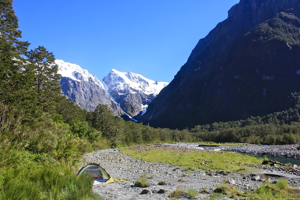
Finally emerging into a grassy alpine valley, we were able to continue on the trail for a further two kilometres, though it became harder to follow. Eventually, it petered out on a gravel bar by the clear, rushing water of the Tutoko River, and here – dirty, muddy and tired – we set up our tent, hid from the sandflies and fell asleep to the sound of the river.
In the morning it was like waking to a different world: the sun was shining and the clouds had burned off to reveal a bowl of jagged peaks glistening with snow and dripping with waterfalls.
Leaving our tent by the river, Jesse and I headed upstream, occasionally boulder-hopping along the river, sometimes veering off into the forest when it became too steep. The water was a pure turquoise that alternated between rushing rapids and deep pools, and it invited us to travel slowly, pausing to watch rare whio (blue ducks) playing in the white water beneath ice-capped peaks.
As we made our way further upstream, the landscape changed and became more rugged. Scars from a recent avalanche were evident, giant beech trees ripped from the ground and strewn across the riverbed; piles of rocks and rubble left atop boulders as though placed there by a mischievous giant. There’s supposedly a rock bivvy at the base of the glacier, but we didn’t see it, and anyhow, it was easier to trip lightly upstream carrying only our lunch, then return to our riverside base camp in the evening, tired, happy and entirely free.
The Tutoko Valley is a remote, spectacular place. Don’t do this as a day hike – give yourself at least one or two nights to explore the valley. It’s unbeatable.
– Krista Langlois

34 years of inspiring New Zealanders to explore the outdoors. Don’t miss out — subscribe today.

Questions? Contact us


