
To mark Wilderness magazine’s 30th anniversary, current and past editors and contributors scoured the archives for the 30 best trips we’ve published over the decades. This story, original published in June 2017, was included. You can find all 30 of the greatest Wilderness trips in the October 2021 issue.
Stewart Island lies between latitudes 46 and 48 degrees, smack in the middle of the Roaring Forties. While the north of the island contains three major tracks, the Rakiura Great Walk, North West Circuit and Southern Circuit, the south remains comparatively wild and untouched.
It’s a vast area of windswept plateaus, granite peaks and huge bogs. It is wilderness in every sense of the word and, apart from the occasional fisherman and the odd hunting party, it’s rarely visited. There are no permanent residents and the land is mostly void of tracks and, for that matter, information. While researching our planned trip, I could only find fragments of intel – talk of a track here, a hunting bivvy there – but in keeping with the wilderness values of the area there is little in the way of solid information available.
Southern Stewart Island is a realm for trampers who take pleasure in not knowing every detail about the route ahead. It’s for those who want to go to a place that isn’t in a guidebook.
As we sped south aboard the Aurora, our captain lifted his hand off the wheel and pointed a finger toward a mass of low clouds clinging to a series of hills. “That’s the Tin Range mate,” he told me, “better you than me at this time of year.”
It was mid May and our ambitious goal was to walk from South Pegasus to the Southern Circuit via the Tin Range. Much of the way is untracked and for the most part we would follow a route used more than 100 years ago by gold and tin miners.
We were dropped at South Pegasus Hunters Hut with a party of hunters who were setting up base for a week. Before departing for Stewart Island, I’d dehydrated every morsel of food we’d be eating and thought about every gram of weight in my pack. I watched enviously as the hunters unloaded case after case of beer and other luxuries, and I couldn’t help but wonder if I had chosen to go with the wrong group.

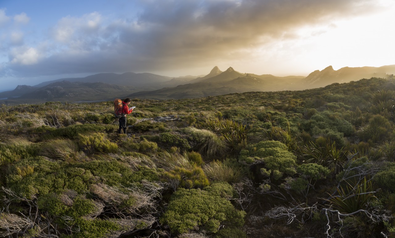
Standing atop Gog, gazing towards Magog. Photo: Neil SilverwoodOur team was pleasantly surprised to discover a marked track leading in our desired direction from behind the hut. But the track soon petered out as we climbed to the scrub line and the going got rougher. It had been many years since I had done a long wilderness trip and soon my knees ached under the weight of an overloaded pack. I secretly wondered if I’d be able to keep this up for 10 days through Rakiura’s southern wilderness.
The area is not officially designated as wilderness – it’s just been proposed. From a legal perspective, designated wilderness areas benefit from a higher level of protection and more concentrated land management. But if you follow the definition of a wilderness area in the Conservation Act – a place free of human structures and development, remote, free of tracks – it fits the bill. Looking at the wild landscape, I could see no sign of human existence and could think of no place more deserving of legal wilderness area protection.
One of the aspects that hit me on the first day was the low bushline. The further south you travel in New Zealand, the lower the bushline becomes. In the central North Island, it sits around 1400m above sea level. By the time you reach Fiordland it averages around 1000m and in southern Stewart Island, it’s just 500m. In many places, with patches of occasional podocarp forest, the scrub line goes right down to sea level.
The scrub is made up predominantly of gnarled manuka, twisted and shaped by the prevailing westerly winds. Amongst this are podocarps such as rimu and miro; usually forest giants, here they are bonsai-like, scraggly, tangled shrubs unable to rise much above the spongy, moss-covered ground. The scrub is, for the most part, easy to travel through as it is broken by areas of tussock and shallow swamp.
After setting up camp in the most sheltered spot we could find – a big ask in a landscape where the highest tree is just one-metre – we set our sights on the iconic peaks of Gog and Magog.
We climbed the north ridge of Gog, an honest scramble up steep granite slabs and through short sections of bush. The view from the flat-topped summit was surreal. Looking north, we could see the Tin Range, to the east the sedate Pacific Ocean, to the west and near the base of Gog, the wild-looking Tasman Sea, and to the south, rolling open country broken only by granite domes defiantly poking above their scrubby prison. It felt more remote than any other place I’ve been in New Zealand.

The next morning we climbed Magog, Gog’s smaller neighbour to the north. From a distance, the mountain appears to be guarded by a wall of impenetrable scrub. To our surprise, we found a well-cut but narrow track on the northern side that led to the austere top; very different in features than Gog. The granite crown of Magog is curvy and covered in weathered potholes, like stone birdbaths, where water swirls and pools during rain.
While celebrating our good fortune at finding a track to the summit and climbing in good weather, we watched a front sweep in from the west, Gog disappearing into its mist. Within minutes the weather overtook us and we were engulfed in heavy rain and wind. Streams formed and ran down the bare granite, forming waterfalls over the cliffs and gullies.
We descended safely and eventually the rain passed. While heading north to the Tin Range, the late afternoon sun illuminated Gog and Magog so they appeared like ancient castles guarding the landscape.
Our route traversed an open plateau for a while, but eventually we dropped into Basin Creek and became immersed in dense, fungi-covered bush where we struggled to make progress. Over two days, we navigated through every sort of bush imaginable – dense, spiky and nearly impenetrable leatherwood, and open, lush areas of podocarp. In hindsight, we thought it may have been preferable to sidle around the northern side of Cook Arm, then make a beeline north toward Belltopper Falls. Better yet would have been to bring a packraft and use the water and tides to our advantage.
Just before Diprose Bay, we stumbled onto a cut track heading to Tin Range. It was marked on our topo as the Tin Range Surveyors Track and beyond it, beginning at Diprose Bay, was the old tramway climbing to an intersection with the Surveyors Track. It seemed ironic to find two well-marked tracks heading nearly parallel and to the same destination after we had spent several days without any trail at all.

That night, we camped at the bottom of the Surveyors Track on the old Pegasus township site and feasted on the local cuisine – pippies, rock oysters, mussels and paua.
Pegasus town is an interesting spot with a rich history. Originally attracted by the lure of gold, miners discovered tin in the black sands in 1888 and the area was rushed for claims. At the height of the tin rush, some 240 miners called Pegasus home and there was even a hotel and post office built there. But the tin was in such small quantities that mining it proved unviable and only a few tonnes were recovered. There is little left now to show for all the miners’ efforts. The bush has reclaimed the land and the only sign of the township is a few bricks and broken bottles. Pegasus is wilderness once again.
After dark, we went looking for kiwi. We had been on the island for five days and other than shrill cries at night and rounded beak holes in the ground, had not managed to see one. This night looked like it would be no different and after searching for half an hour we were about to turn around when a pair of kiwi walked out of the bush and began digging for worms right in our path. They walked toward us as they foraged, seemingly taking no notice that we were there. We stood mesmerised, watching them for several minutes. If nothing else, it was worth coming to Stewart Island to see these birds in the wild. In the following days, we came across several more.
After a day exploring the various nooks and crannies around Pegasus, including the impressive Belltopper Falls, we drifted up the Surveyors Track. We found a link between it and the tramway well before they intersected and finished an early day along the Tin Range Tramway at the old miner’s dam, right at the end of the track. The soft gradient and broad girth of the tramway was a welcome change to the undulating, trackless terrain to the south. We found the dam site to be the best camping spot of the trip – good flat spaces, shelter from the wind and plenty of water.
It was grim the next morning. Heavy cloud engulfed the Tin Range and with map, compass and GPS we travelled in near whiteout conditions. We made it past the relative shelter of Mt Allen and halfway to Rakeahua Hut on the Southern Circuit before tiring of the slow going and of being wet through and blown off our feet. We put up our tents in the lee of the range, in a steady drizzle and roaring winds, on the only bit of flat-ish ground we could find. Our plot was so small that our tents touched each other and we only had to reach under the fly to pass food between us.

We woke to more strong winds and complete clag. I walked up to the range to view the conditions. It was almost impossible to walk in the strong winds and visibility was poor, so I retreated to the tent for the day.
The lower lee side of the range offered little shelter and a much tougher route through dense bush. But staying put turned out to be a bad decision. That night we were caught in a raging storm with even stronger winds. We tried futilely to peg our tents out with rocks until the guy wires chaffed through. We had a sleepless night re-pegging the tent every couple of hours and trying to keep it from blowing away. Any bit of fabric that came loose sounded like a roaring helicopter and water seeped in wherever it could.
Eventually the wind blew itself out and after two nights hunkered down, we carried on along the broad Tin Range. It was easy travel following sparsely placed tombstone-like rocks that had been stood on end to act as cairns. Just to the north of Table Hill, we found a poled route leading to an unofficial track. It intersected the Southern Circuit and took us to Rakeahua Hut, which was a taste of luxury on our last night in the wild. From here, it was a half day walk to Fred’s Camp Hut and our booked water taxi.
Note: We have only plotted the route from Diprose Bay to Freds Camp Hut. We did not include the first section from Pegasus, Gog and Magog due to the nature of travel here. It is very much find your own way.


