

(Listen to Ray read his story with a follow-up Q&A about the trip with our editor.)
The definition of an adventure is that the outcome cannot be predicted. One has no guarantee of fine weather, the availability of huts or the fitness of companions. My cunning plan was to utilise a section of Te Araroa Trail for the days with poor weather, then launch out into the unknown during the fine weather. So I chose an adventurous off-track ramble over The Nelson Tops, a sprawling range located between the Hope and Hurunui rivers in Lake Sumner Forest Park, to add spice to what would otherwise have been a rather pedestrian outing, and threw in a couple of secret hot springs for good measure. My itinerary promised an eclectic mix of pleasure, pain and zombie walking.
Our diverse party of veterans and newbies was eager to explore new territory. We convened at the Boyle River Outdoor Education Centre where a volunteer warden drove us to the trackhead at Windy Point. We shouldered unwieldy packs and followed a 4WD road to the swingbridge over the Boyle River, a dramatic place where the river’s power is evident.
A gnarly wee trail wound through regenerating scrub then spat us out on a 4WD track that skirted a deer fence. We eventually reached Hope Kiwi Track, which led through beech forest and across gullies, skirting the valley wall a long way from Hope River, where cattle grazed on grassy terraces.
After three hours, Hope Halfway Hut appeared through a curtain of rain. This six-bunk shelter is unappealing but offered respite from the weather. A trio of TA walkers camped in one corner while we boiled a brew.
I was suspicious of my friend Joanna’s heavy pack and decided to inspect the contents: a whisky bottle, shampoo, a hair brush and enough food to feed an army. Oops, I should’ve checked her gear before departure. This was her first overnight tramp and her first time carrying a hefty pack. I knew her lack of experience would be mitigated by her incredible drive to succeed and her infectious enthusiasm, but even so, we stowed 5kg of excess gear under the hut. With barely enough daylight to reach St Jacobs Hut, Jo and I then headed off together to chase down our companions.

We pushed on across pleasant grassy flats, jumping bits of bog before crossing another bridge that spanned an impressive slot canyon in Hope River. On the far side a zig-zag trail climbed to a junction where Hope Pass Track switched north, cutting a corner over a ridge to reach more river terraces upstream. As night fell we stumbled into the two-roomed six-bunker at the bush edge. We had walked 18km.
The otherwise tidy hut was stained with smoke from a thousand fires. I recall it was occupied by hunters on my last visit, when stags roared louder than the river and the hills were alive with the sound of gunfire. Tonight, we were relieved to have the place to ourselves, and Jo was excited to spend her first night in a backcountry hut.
The next day 10 souls followed a poled route as one, cruising along cattle flats, weaving through matagouri thickets and threading through a labyrinth of swamps. Hares bolted from hutches and Canada geese honked. The country we walked through had been heavily modified, and introduced animal species seemed to dominate.
Top Hope Hut was empty and sported a grand view across the valley to the Doubtful Range. Five of us made a recce up-river to locate Hot Spring Stream. Packless, we moved fast, criss-crossing the river to make a direct line up-valley. The tell-tale smell of sulphur lured us onward, negotiating log-jams in the creek, and there it was: two natural spa pools lined with river stones. We soaked in the heated water for an age like excited children. After this delightful taste of decadence, we returned to the hut in anticipation of a big day ahead.
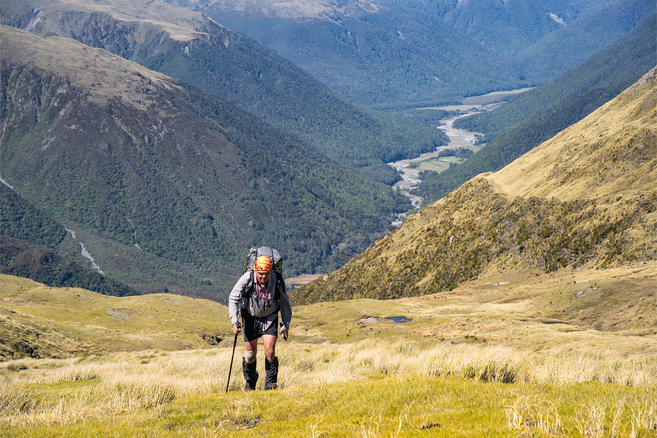
A smart start saw us marching in a line towards the valley head and Hope Pass. The two scouts leap-frogged each other, backing off from false leads as they searched for the elusive marker poles. As the valley narrowed we endured wet-boot crossings to make efficient progress through stunted scrub, and after three hours of steady tramping we popped out into the open tussock on Hope Pass (951m), with one foot in Canterbury and the other in Westland. We filled drink bottles and set the compass. The forecast was for a window of two days’ sunshine for our adventure over The Nelson Tops.
Greg made fast headway up the hill, pushing through thick scrub on a southerly bearing. We followed tentatively as his pack was swallowed by impenetrable foliage. Eventually his enthusiastic efforts waned and he was bushed. I discovered a new direction of travel until I too reached an impasse. Janey forged ahead on a new lead. We were sweating profusely in the heat, squeezing overladen packs through narrow gaps where they inevitably got tangled, our limbs scratched and bleeding.
After two gruelling hours of aggressive bashing through flax and stunted dracophyllum, we topped out onto the open mountainside, elated. Another hour saw us arrive on a modest 1500m knob. The views were breathtaking but we were out of breath. I endeavoured to keep my party together as we traversed gentle tussock slopes to a saddle. Dark craggy peaks loomed above, but by sidling along the 1500m contour we maintained a steady altitude, wading through long grass to reach a deeply incised gully.
After 10 hours’ hard yakka, we voted to pitch camp here. Our idyllic mountain eyrie granted a grandstand view south to the serrated peaks of Arthur’s Pass, backlit by the setting sun. A gentle zephyr caressed our tiny tent village.
We woke to clear weather, high above the sandfly zone. Greg and I chose a potential escape route off the exposed tops. A line of parallel ridges dropped from the golden tarn-studded plateau. One particular spur had no scrub and a moderate gradient, and we aimed for this, some 3km away to the southwest.
As trip leader, I felt the weight of responsibility for finding a passage through unfamiliar terrain. So I shepherded the group down an undulating spine, along a grassy expanse, past a boneyard of deer skulls to a smattering of small tarns. Greg boldly led us down our selected spur and we soon reached Mackenzie Stream. A few of us ventured upstream to visit Mackenzie Bivouac, which is sited on a grassy bank. Inside the tidy two-bunker, meticulously carved into the wooden wall panels, was a bush poem from the 1960s. The author was legendary ranger Max Polglaze, a humble deer culler here in his youth.
Our jubilation upon reaching the stream was stymied as we began our descent down the untracked valley. Giant landslides and rockfall have demolished the forest. Vertical valley walls hemmed us in so there was no option but to continue downstream. This unmarked route would be treacherous after a storm, and we were grateful the weather was holding – just. We scrambled over fallen trees, zig-zagging through the swift current to make meagre progress.
Somehow we found a way forward. After three hours of intense river travel we arrived at the main flow of Mackenzie Stream and a chorus of hurrahs rang across the valley as we spotted an orange track marker. The sparsely marked Mackenzie Stream Route led to extensive river flats, where we established camp. Sandflies and showers forced us into our tents for a damp evening.
On our fifth day we stowed wet tents into wet packs and pulled wet boots over wet socks. Splashing across the wide Hurunui River, we were thrilled to find the hot springs perched 20m above the track. Stripping down to underwear, we submerged our battered bodies into the 40℃ pool. In moments such as this, life is good.
We arrived at spacious Hurunui Hut in time for lunch before the rain returned. A bunch of TA SOBOs were in residence. The afternoon was spent wandering the vast valley, skirting the bush edge on cattle flats. The group spread out, lost in our own worlds. Joanna had found her mojo. The 33-year-old was out in front, leading the pack, and I was proud of her new-found confidence.
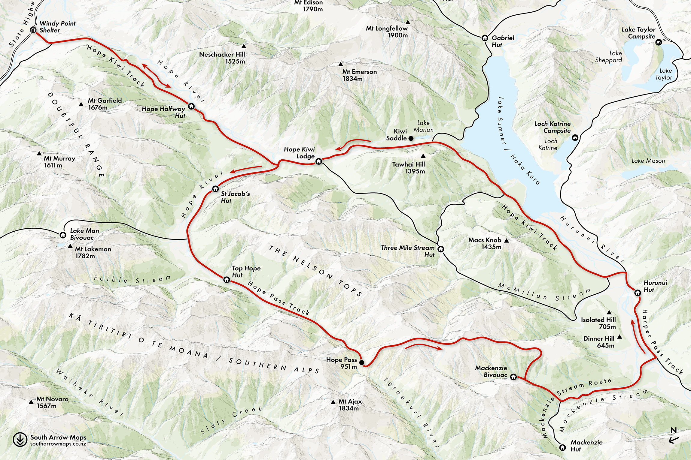
Late in the day we reached the somnolent shores of Lake Sumner. Here, a relentlessly nice path of scattered beech leaves skirted the lake shore, climbing toward Kiwi Saddle, although a couple of steep sections proved to be the sting in the tail as we forced aching legs onward.
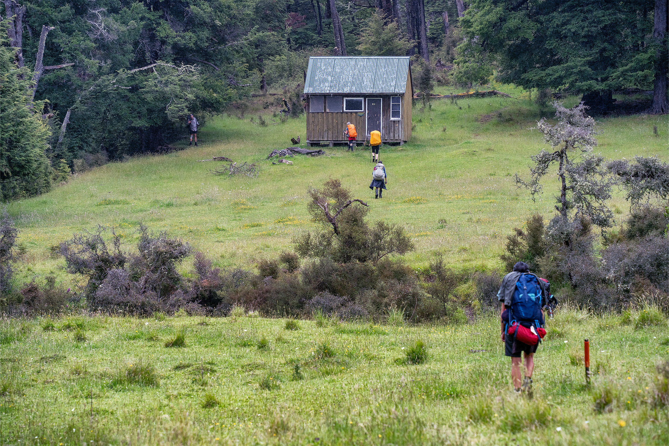
After twelve hours our boots had clocked up 25km. We were now scattered across a lush green paddock that sloped down to Hope Kiwi Lodge, a Lockwood building with two sizable bunkrooms and a generous lounge. TA walkers had the woodstove pumped up. We were glad to sleep on mattresses for our final night together.
The last day was largely a repeat of the first, albeit in the reverse direction. Once beyond the Hope River bridge it was the same route, same showery weather, same cowpats, same boggy terraces. Janey and I volunteered to hitchhike back to Boyle River to retrieve our vehicles and we reunited at a café in Murchison.
We had strayed off the beaten track into a seldom-visited neck of the woods and forged our own furrow over the Main Divide. We had forced a route down a ravine choked with fallen trees and indulged in the luxury of hot pools. We had walked 100km in six days.
Joanna reflected on her first tramp: “Thank you for the adventure of a lifetime. I will always remember it with great fondness. I actually loved every moment of it.”


