
“Man, I’m glad to be here,” he said. “The adrenalin was pumping out there for a bit, before I saw your candlelight in the window.” His only light source was his smartphone.
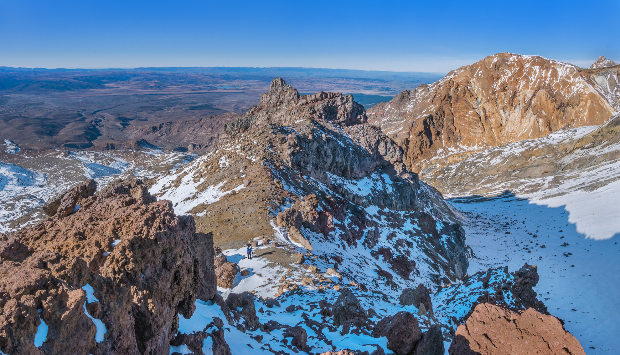
Before setting off the next morning, we cautioned Jamie to be extremely careful if he chose to ascend to the Summit Plateau, pointing out that climbing down is usually harder than going up. He was soon forgotten though as we became immersed in our own climbing up the craggy ridge towards Cathedral Rocks.
It was a beautiful morning and stretches of frozen snow provided the perfect crampon surface. In other places it was very hard, requiring care and concentration as we alternated between white stuff and volcanic rock. My pack felt better now and my sense of well-being became even stronger when we breached the crater wall east of Cathedral Rocks.
The Summit Plateau looked stunning in the bright sunlight. Certainly alpine, but not fully snow-coated, with patches of rich volcanic yellow, orange and crimson rock placing us in photographic nirvana.
By midday, we were setting up camp on top of the 2672m Dome. It was so calm, we could leave our gear scattered about as we pleased. And there aren’t many ‘rooms’ in the North Island with a better view than our tent on the Dome.
After lunch, Shaun felt like some downtime but I was keen to use the conditions to do a little packless exploring. My plan was to circumnavigate Crater Lake, as I’d done alone once before in winter conditions. But it soon became apparent that in the thinner autumn conditions, the route was considerably more tenuous – a lot of very loose scoria and rubble, interspersed with patches of hard ice, all mixed with plenty of exposure. At the first highpoint on the east side of the lake, I lowered my tail and retraced my steps.
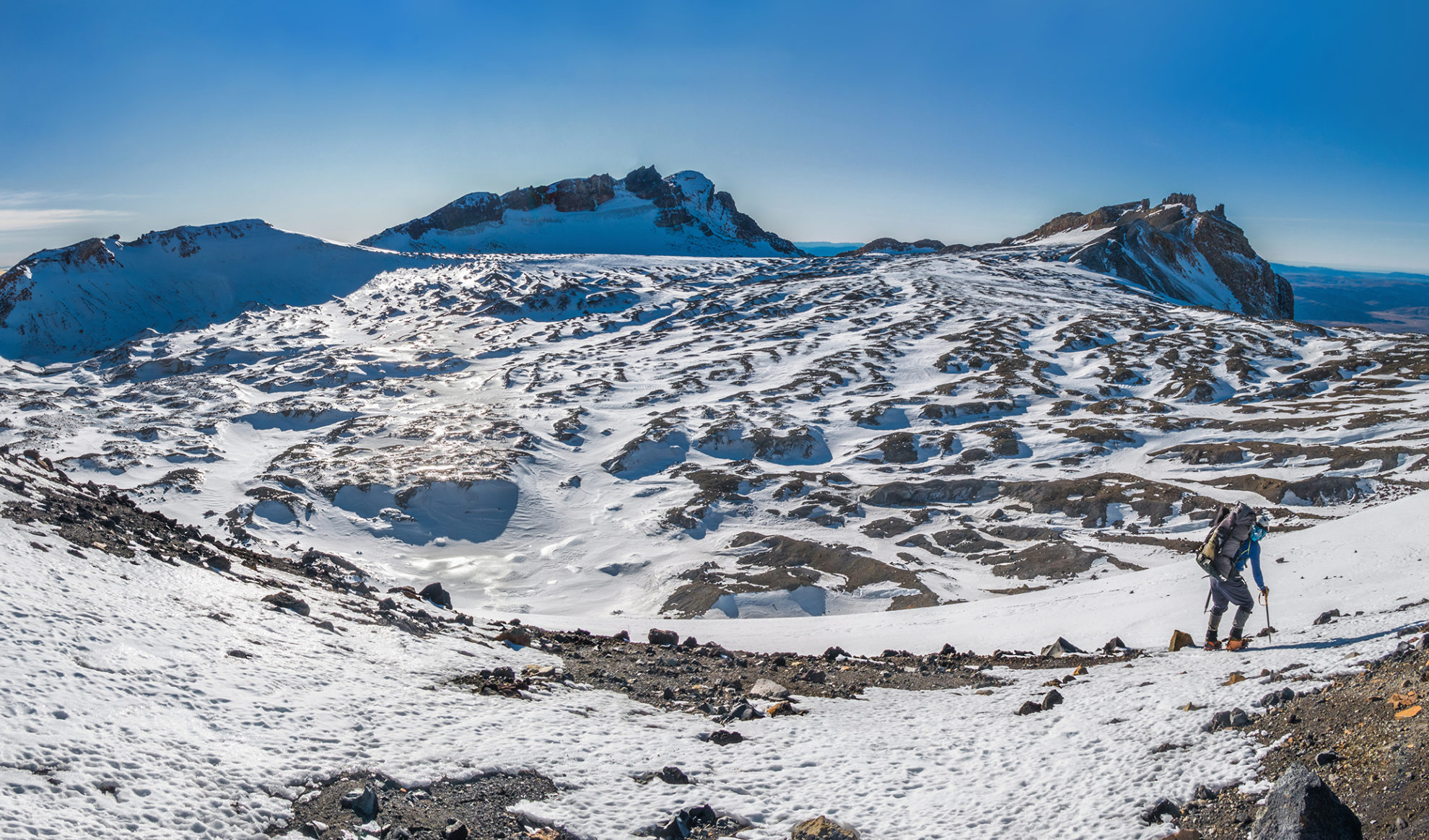
My consolation was a plug up to the steep, iced-up crags that started about 30m beneath the summit of Paretetaitonga, from which there is a panorama of the entire plateau, as well as Mt Ngauruhoe to the north-east.
As dusk unfolded, a tiny figure appeared east of Dome. “No way, I hope he’s got a tent with him,” I said to Shaun, imagining the uncomfortable night ahead of us in our little tent if he didn’t. “At least he’s still alive.”
Jamie did have a tent and a Spiderman costume which, while shivering, he scrambled into so we could take photos of him for his son back home. It was the first time either of us had spent any time with a comic book superhero on a mountain top.
Once the sun went down there was little else to do but hunker down in our bags. All night there was no more than a light breeze. Shaun and I knew such conditions on the plateau are a gift.
Once packed, we bid farewell to Spiderman and encouraged him to join a New Zealand Alpine Club snowcraft course as soon as possible. He clearly had drive and strength. And no doubt good balance too, considering the terrain he’d covered in his inadequate climbing gear.
An hour later, Shaun and I began climbing up the northern crater rim towards Tukino Peak. I’d climbed Te Heuheu several times before but only visited Tukino once. That time, Tukino was a mass of rime ice, jutting out into a cavernous void. This time, there was just volcanic rock but the vertigo-inducing void remained.
Though Te Heuheu is slightly higher than Tukino, its summit is much friendlier. We enjoyed some time up there in calm conditions marvelling at the view. Mt Taranaki was visible on the western horizon. By now though, cirrus tendrils had appeared, reaching across the sky from the north-west to announce a coming weather change.
We dropped off Te Heuheu and considered what the best route of descent might be. To our left, Pinnacle Ridge looked like a gnarly place. But our intended route, down Waihohonu Ridge, also didn’t look appealing. When I imagine volcanic cones, I see quite uniform slopes. The reality is a world of craggy lines, punctuated by bluffs. It’s OK when you can see the bluffs, but often they’re hidden from above and 20m topo lines can also easily hide them.
Shaun led off, picking a route down the broken ridge. Our crampons remained on, even below the snowline, providing much more stability in the ball-bearing-like scoria.
We had originally intended to make our way over to the highpoint between the Tama Lakes to camp. At 2000m, however, we arrived on a broad section of ridge and a great spot to pitch the tent. To our right was a big sloping slab of frozen snow, providing all the water we could need, and the view north to Ngauruhoe was superb – far better than the foreshortened version would be from above the Tama Lakes.
Though we’d been on the move for less than five hours, we called time. The sky above was white with high cloud and there was plenty of interesting action going on nearer to earth to the west. The forecast was barring out, so better to have less distance to walk back to our car the next morning.
By early morning, our light tent was getting a windy workout. Later, as we packed up camp, a gust pounced from nowhere, snatching away the tent bag and nearly doing the same to the partially-collapsed tent itself. Shaun donned crampons, shouldered his pack and headed into a stream gully to retrieve the bag. I took a snow-free route further down the ridge, eventually reuniting with him a few hundred metres lower down.
Despite the weather change, or perhaps because of it, the landscape also changed. Bleak, but still texturally magnificent, and when sunbeams breached the thickening cloud, drama unfolded.
Once again, the terrain proved deceptive. What appeared as low gradient, rolling scoria actually concealed stream beds fringed by those less than topo-20-metre high cliffs. At one point, we tried to drop into the dry stream-bed that the map told us would lead to the Round The Mountain Track, but the lowest point in the cliff wall, just three metres high, was still enough to block us. By now, very low cloud put us in and out of a whiteout, adding to the adventure.
Eventually we did reach the stream-bed, enjoying yet another visually spectacular perspective up to sheer rocky walls which at times resembled a mini Grand Canyon.
A couple of hours after leaving our campsite, we hit the Round The Mountain Track and turned right, back to our car.


