A thriving environment, home to native bush and vibrant birdlife all protected by a predator proof fence is just one highlight on this Waikato getaway, writes Matthew Pike
Many of you will have driven the main roads in the Hamilton region and seen plenty of dairy farms, a large river… and perhaps little else. If you were planning a walking trip, the odds are you’ll have carried on towards Rotorua, Taupo or Coromandel without sparing the region much thought.
I’d driven through plenty of times without entertaining the thought of stopping, even for a short stroll, let alone a weekend away. Why would I, with ‘box office’ walking locations such as the Coromandel so near?
Well, I spent a weekend there recently and found two gems that left me thinking ‘why had I never heard of these places before’?
Maungatautari is a weathered volcano that rises from the surrounding paddocks. And it’s the largest mainland predator-free sanctuary in the country. A 47km fence surrounds the entire mountain which means, more than anywhere on the mainland, you gain a sense of wilderness in a pest-free environment.
Intensive enclosures in both the northern and southern end of the mountain ensure re-introduced and often rare species are closely monitored. And while the enclosures themselves don’t feel quite like true backcountry, they provide an excellent chance of seeing the likes of kaka, saddleback and giant weta, and their success will result in overspill of native species to the main forest.
It’s already an obviously thriving environment – the forest itself looks far healthier than one ravaged by possums and nearly every time you stop, there’ll be a fantail or tomtit dancing in the surrounding trees.
If you’re staying at the southern end of the mountain, there are a series of easy walks in the southern enclosure (entry $15) that head through beautiful forest with giant rimu trees, plenty of birdlife and information about the trees and birds as you go. There’s also a wooden tower you can climb for a canopy perspective of the forest. Expect to see kaka squawking and flying beneath you.
Those preferring a full tough day can try the ‘Over the Mountain Track’ – a five-six hour traverse of the reserve, which requires someone to pick you up from the other end.
I was surprised to discover that many locals haven’t heard of the second gem I discovered on my weekend away. My host at Out in the Styx recommended it as the best short walk in New Zealand. Assuming local bias, I was a little sceptical but the message was clear – I should give it a try.
Pukeatua, Maungatautari Ecological Reserve
There are two ways up – the new track and the old track. The new track is the easier option, though a short scramble is still required to reach the summit. The old track is more of a backcountry experience and involves more scrambling. Head up via the old track and down via the new if you have reasonable fitness but untrustworthy knees.
Park in front of the fence, head through the turnstile and the kissing gate and turn left at the fence. After 20m head through the double gate and follow the fence for 500m. Take the smaller track forking left signed to the Over the Mountain Track.
Ignore the first sign pointing right to the old track. It merely takes you on a short, unnecessary detour which rejoins the new track a few hundred metres later. Take the old track at the second orange sign which says ‘Old track to Rocky Outcrop and Pukeatua Peak’. Follow the orange markers which lead you up the ridge.
A very steep section takes you scrambling up to Rocky Outcrop. Usefully placed tree roots make the scramble relatively easy and the views of the likes of Pirongia and Lake Anapura and the distant Mt Ruapehu from the top are terrific.
The track drops just as steeply to a saddle where you meet the new track briefly, before a rough steep path takes you to the top of Pukeatua Peak, this time for views north west towards the Kaimais.
Climb down the way you came until you reach the new track at the saddle, then follow this as it weaves all the way down to the car park.
Wild file
Access From SH3, turn onto Arapuni Road at Kihikihi, then after 22km turn left onto Tari Road and park before predator fence
Grade Moderate
Time 4-5hr
Map BE34
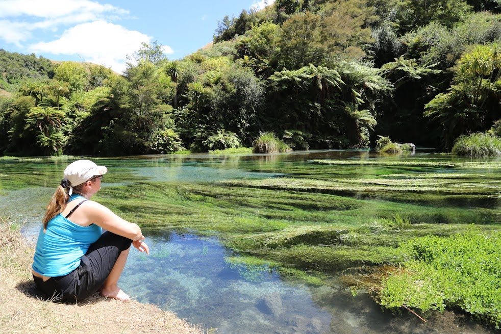
Te Waihou Walkway and Blue Spring
Blue Spring has to be one of New Zealand’s great secrets. Similar in colour and clarity to Waikoropupu Springs in Golden Bay, the water emerges having been underground for many years. Unlike ‘Pupu Springs’ you’re allowed to take a dip, but be warned – it’s always 11 degrees Celsius guaranteed to make you yelp.
The most satisfying way to see the spring is after a 5km walk from Whites Road. Otherwise, the spring can be reached in around 15-minutes from Leslie Road if you’re short of time or energy.
The start of the walk from the car park at Whites Road is clearly marked and a well graded path hugs the right-hand-side of the Waihou River.
After 2km a bridge gives you the option of continuing upstream on the left or right of the river. Both options stay close to the water, rising higher on the bank, before another bridge 500m further on ends the loop and you continue on the right hand side of the river.
A little further upstream the valley closes around you and the river flows fast over the rocks. A small water wheel is an interesting distraction and there are some steep steps to climb.
After this, the valley and river broaden and you start to see the beautiful turquoise water. Picturesque rocks on the opposing hillside precede the pièce de résistance, which is Blue Spring. A path leads up to a lookout with great views over the spring.
Continue along the track until you reach a bridge, from which you get a fantastic final view of this most beautiful of rivers. The Leslie Road car park is another five minutes’ walk, but if you’re doing the return leg it’s best to turn around at the bridge.
Wild file
Access From SH1, just north of Putaruru, turn onto Whites Road (SH28) and after 3km a sign to Te Waihou Walkway points you to a car park on your right
Grade Easy
Time 2-3hr return
Map BE35
Nearby
Out in the Styx Perfectly situated accommodation at the foot of Maungatautari. You can easily walk to the start of the track from here and, if you’d like to do the full mountain traverse, or one of the Waikato River trails, owner Lance Hodgson will give you a lift. Chose from bunk rooms or ensuites. It’s well worth paying the extra for the four-course set-menu dinner after your first day’s walk and the hearty breakfast to get you going.
Waikato River trails A series of easy trails suitable for walkers and cyclists that follow the path of the Waikato River.
Hobbiton Do like Frodo and have a pint of ale at the Green Dragon Pub.