In the late 1970s, a road linking Golden Bay with Karamea was proposed. It would create jobs, assist with tourism, and open up the north-west Nelson region. There was one little problem: it would all but destroy the historic Heaphy Track.
The tramping community went into a furore at such apparently greedy, and ignorant, ecological insensitivity. Hundreds of Kiwis beat a determined path up the Aorere Valley to ‘do the Heaphy’ before it became a bitumen highway. In 1977, my father dragged me there, in my gumboots, through the primeval rainforest and knee-deep mud, overnighting in decrepit huts with resident possums for company.
The road never happened. The Heaphy Highway died in its tracks, but has developed into a popular Great Walk and mountain bike trail.
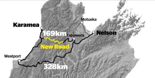
But now, Buller mayor Garry Howard is lamenting the loss of some 600 jobs on the West Coast due to a slump in the coal industry and has mooted the possibility of a new bitumen highway: the Wangapeka Road link. His silver bullet to the region’s problems is to build a road from Tapawera to Karamea, halving the travel time to Nelson. He reckons it will provide employment for hundreds, and attract thousands of paying tourists to the remote region north of Westport.
Except there’s a little problem. The proposed 59km road will slice Kahurangi National Park in two and completely destroy the Wangapeka Track. The road route is also home to blue duck and endangered rock wren. Here we go again.
During Queen’s Birthday Weekend this year, our tramping club decided to give the mayor a helping hand. We would walk his proposed highway to test the feasibility of such an ambitious agenda. Our mandate was to answer the question: Is the Wangapeka worth saving?
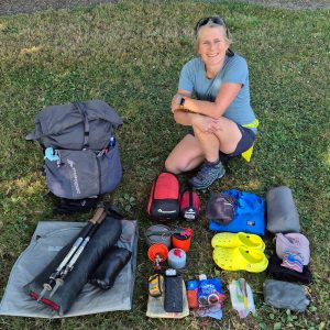
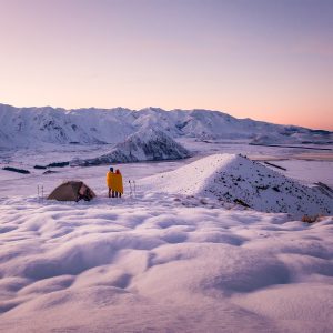
Standing at Rolling River, assembled in our polyprop, beanies and mittens; donning leather boots, gaiters and backpacks that have seen better days, we were soon ready to find our answer. The average age was 64. I was the youngest and perhaps the most stupid, hauling a hefty 25kg pack which included homemade street signs and a hammer. My crazy idea was to install a few road signs along the route – perhaps it could be enhanced with some brightly-coloured, geometrically-shaped pictograms?
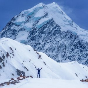
Off we went, crossing the first of many swingbridges and striding out along the first of many frozen river flats, craning our necks at the stupendous, triple-spired summit of Mt Patriarch crowned in white and dominating the valley below.
But just an hour’s jaunt up the benched track, and it became a rough route which had us scrambling over debris from a 2012 landslide. The skeletons of drowned trees punctuated a one-kilometre-long lake, as yet unnamed. Beyond this natural dam, we regained the old gold diggers’ trail, skirting above small gorges where the Wangapeka River squeezes through the granite, emptying into pools of deep green. In one of these we discovered a trio of whio. Grabbing my camera, I stealthily crept into position. Click! I got all my ducks in a row.

The whio population in these parts totals about 60 birds and the Wangapeka is one of eight strategic sites developed to protect this threatened species.
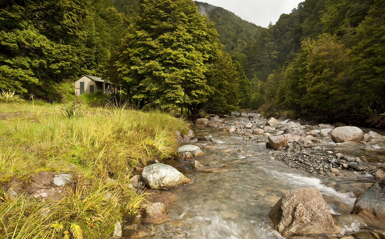
The sunless winter had arrived at Kings Creek; both huts are giant freezers, locked into a world of white permafrost. We crunched through ice-encrusted puddles along the easy but greasy track, ever upward.
The beanies stayed on our heads as we pushed on toward Stone Hut at the valley head. Darkness fell quickly as we gathered around the bush telly, absorbing its warmth and inhaling wood smoke.
At some ungodly hour our intrepid leader roused us, urging our aching bodies into action. Hours before sunrise, we stumbled around in the frigid cold to eat breakfast. By torchlight we walked, in single file, silent, wrapped up like Egyptian mummies.
Soon we were climbing to the pass, somewhere ahead in the predawn murk. The ascent was mercifully gentle, and we barely sweated in the single-digit climate. At Wangapeka Saddle there is no decent view, so we posed for a group photograph in the dim half-light.
We tiptoed along a walk-wire above Chime Creek. Below the pass, the track spat us out onto the Karamea River headwaters, frozen in time like a scene from Narnia.
Recent weather events had wrought havoc in this corner of Kahurangi. We opted for the high-sidle track, to keep our feet from frostbite. But the route was torturous and time-consuming and when we traversed the high-wire bridge to Helicopter Flat Hut, lunch was long overdue.
The weak, winter sunlight gave feeble heat, then left us chilled to the bone when it disappeared behind the mountains. We scrambled for our gloves and hats, somberly discussing the mission ahead. Only halfway to our destination, it was inevitable that we would run out of daylight. Our group was divided into an advance party of faster folks and a party of plodders, which included me.
Hours passed, as we traversed the valley wall on a good, benched path to a signposted junction. Here, remnants of Jonathan Brough’s tabernacle – an A-frame shelter – lay testament to his track-building efforts in the late 1890s. Rusted shovels and picks have been left beside the track as a reminder of the back-breaking slog still required to build and maintain this track, now more than 150 years old.
It was nearly night when I led my two colleagues over a swingbridge and up the Taipo River. This section of trail is almost benign, cutting a path through forest over ancient river flats. Except it is cold, wet and dark. I searched intently for the orange markers, and then glanced behind for the jiggling headlamps of those following. Our pace had slowed to a crawl.
When we walked into the huge 16-bunk Taipo Hut, we had been on our bruised feet for 11 hours. It was a welcome relief to reunite with our cross-over party, who were walking the Wangapeka in the reverse direction. They had the wood stove cranked up and gave us warm tea to drink. After swapping stories and car keys, we collapsed into the bunks. Sleep came quickly.

We departed Taipo Hut at 7am. By torchlight, we reached a bridge, a bottleneck where we regathered. A second alpine pass was the day’s objective. The initial climb was soon dispensed with, and we arrived at the two-berth Stag Flat Shelter in good spirits. The tussock clearing was a giant white blanket: each plant was freeze-blasted in ice; each puddle frosted like plate glass.
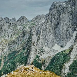
Atop Little Wanganui Saddle, we snapped obligatory photos before the biting breeze sent us scampering down to warmer climes. I decided to wait for the sun to crest the range. I could see the distant Tasman Sea, framed by the valley walls ahead; the twin Saddle Lakes providing some foreground interest. The highest point on the Wangapeka Track also provided the best vantage point.
I erected my DIY street sign in a prominent position, and then snapped a few photographs. Some well-placed road signs seemed to enhance the landscape; the red and yellow primary colours contrasted well with the cool blue and green hues of nature.
Our party rendezvoused in the open sunshine at Little Wanganui Gorge Shelter, a relatively new two-bunk portacom just off the track. Another swingbridge sent us into the dark shadows of the north bank. The old pack track dropped us out at the riverside before returning us to the eternal dampness of the muddy footpath. DOC has downgraded this western section of the Wangapeka into a ‘marked route’ because rough weather events have dramatically damaged the valley. A trifecta of landslides, treefall and erosion has created a ‘perfect storm’ of obstacles that we cautiously negotiated.
The hours ticked by. Above Tangent Creek we tottered, admiring a mossy green waterfall from the footbridge above. At McHarrie Creek there is no such amenity. We were forced to descend a frightening rock face with dubious handholds. From then on, innumerable blockages impeded our forward progress as we struggled on in the impending darkness. Over trees. Under trees. Around trees.
The night enveloped us like a shroud. We were walking through our own nightmare, prodding the bogs ahead with walking poles, searching for markers with fading headlamps.
Another 11-hour epic saw us reach the safety of Belltown Manunui Hut, dead on our feet.
On our final day, we had a deserved sleep-in and didn’t hit the track until after 9am. Legs were aching, feet were swollen, but our spirits were high now the worst was over. The Little Wanganui River – which is actually quite a large waterway – tumbled toward the Tasman, sandwiched between the river banks, on top of which is regenerating farmland. The track had lost its notoriety; being level and easy underfoot, it was almost delightful.
In three leisurely hours we arrived at our vehicles, about 16km south of Karamea. Within an hour we were huddled around steaming coffees inside the sunlit porch of the Denniston Dog in Westport. Mission accomplished.
We chatted about the proposed road and came to the conclusion it will never eventuate. It appears to be a knee-jerk solution to a problem that can be solved with more ingenuity, and more long-term consideration for the environmental impact and historical preservation. The Wangapeka Road link will go the way of the Heaphy and the Hollyford roads, which never got off the ground.
The rugged terrain is so torturous in places that building, let alone maintaining, a two-lane highway is fraught with difficulties. Even DOC finds it too hard to maintain a narrow footpath.
I find it somewhat ironic that mayor Garry Howard’s pre-election promise of a $500m road is popular with his constituents, while on the other hand, the government can’t find the funds to fix the current track.
So, is the Wangapeka worth preserving? I believe it is. While some of the track is clearly in urgent need of some TLC, the eight huts are in good order and the birdlife is thriving. In summer, the tramp isn’t as arduous as I have described and can be linked with the Leslie-Karamea circuit, or the Matiri Valley. The Wangapeka Track is also the launch-pad for several other worthwhile detours such as Biggs Tops and Mts Luna and Patriarch.
To quote MP Damien O’Connor: “People go to the Coast for its natural environment and isolation.” The mayor’s road corridor would ruin the beautiful seclusion and biodiversity that make this place such a tourist drawcard.
Extra funding in this neck of the woods could upgrade the Wangapeka to its former glory as a loop option with the Heaphy Track. This would help solve the transport issue in getting Great Walkers back to Nelson, and give opportunity for Coasters to provide a shuttle service and accommodation in Karamea. Regular maintenance of the track and hut network will also supply ongoing jobs for the Coasters who desperately need it.
Long live the Wangapeka!