
It seems our most memorable tramping adventures always start with gazing at a map, wondering about routes, tracks and peaks, pondering the possibilities.
Tracing my finger over the huge spread of Kahurangi mountains on the topo map, I noticed a track marked from the Wangapeka Saddle up to Nugget Knob and a track from Hurricane Hut to Pt1442, with the Matiri Range in between.
Could the two be joined? With friends Ray Salisbury and Jim Davidson, we set off to find out.
In blistering 30℃ heat, we hopped across the Matiri River West Branch into the shade of the bush. With hefty packs, we tip-toed through bracken, blackberry, clover and long grass – the rocky Lake Matiri Track was seriously overgrown.
Past a weathered signpost, we entered Matiri Forest, where the high-level track had collapsed into the river. The trail gradually climbed to the natural dam which blocked the Matiri River centuries ago. Halfway around the lakeside, the eight-bunk Lake Matiri Hut is perched on a high shelf. We enjoyed a brew, mindful of the wasps which were creeping under the door.
Back on track, the brutal summer heat inspired a spontaneous swim.
Stripping to our undies, we were soon bathing in the cool waters of Lake Matiri. Paradise ducks live here during their moulting season, along with grey ducks, mallard and scaup.
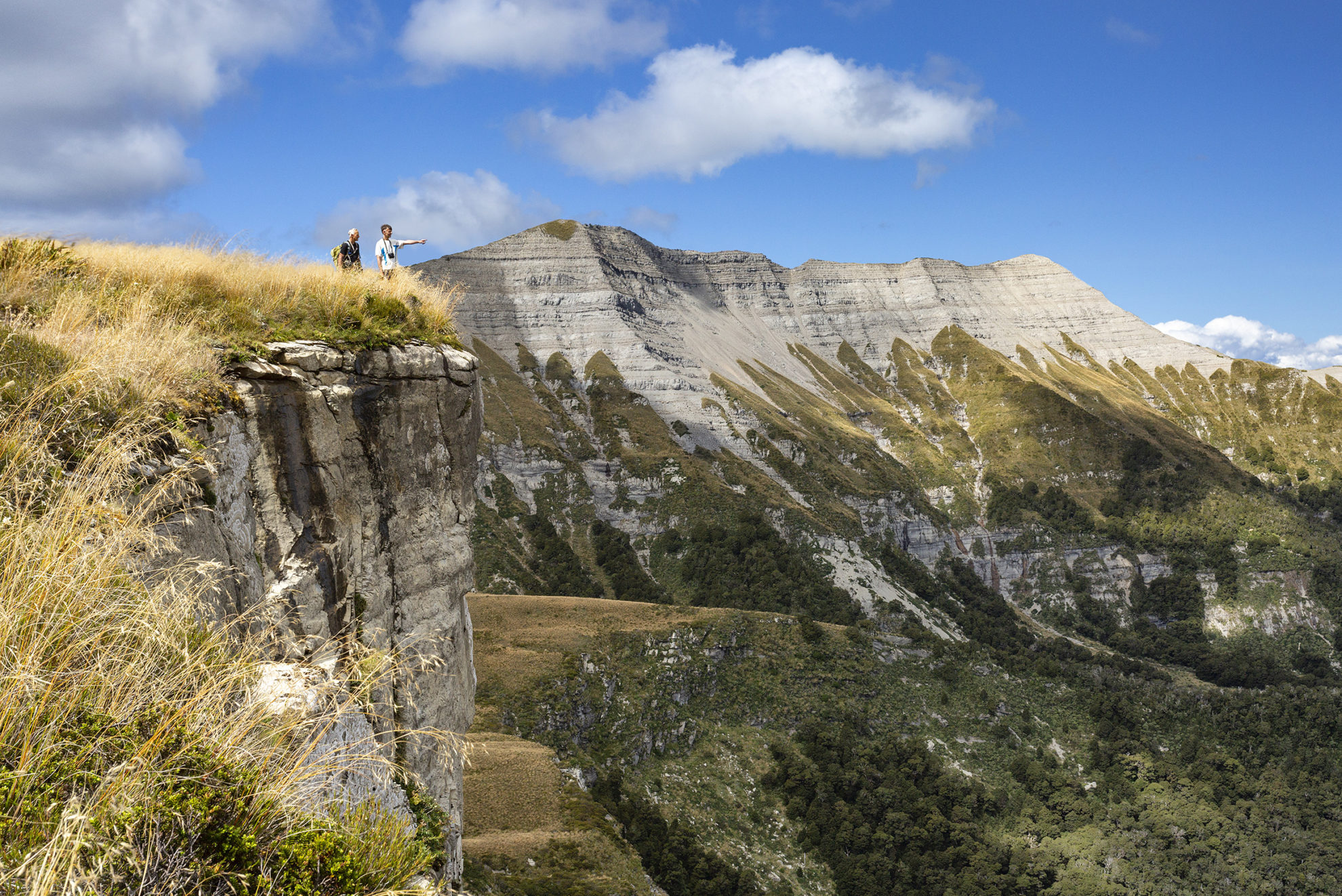
Then began our assault on the spur which climbs abruptly onto the Thousand Acres Plateau, some 700m above. We were relieved – and very hot – to reach the lookout which has a fantastic view over the valley. From this vantage, the Matiri River looks serpentine, curving its way into the lake.
The gruelling ascent was made pleasant with friendly pīwakawaka, robins and bellbirds in abundance. Flora includes rātā, neinei, toatoa and kāmahi, plus silver and mountain beech at higher altitude.
Finally, after nearly four hours’ climbing, we reached the wide-open expanse of the Thousand Acres Plateau, truly an island in the sky. Twenty minutes’ walk through waist-high tussock saw us at the new incarnation of Poor Pete’s Hut. There are only two bunks, but there’s space for a third person on the floor. A covered porch is useful for cooking, while the large wooden deck is perfectly positioned to soak up the sunlight.
Next day, a quick breakfast soon saw us following a poled route northwards, over a series of rolling ridges that reminded us that plateaux are not really flat. We dipped in and out of several watercourses that cut through the undulating terrain, flowing over slippery limestone. Large daisies contrasted with a mosaic of flax, Astellas and hebes. The early graziers regularly set fire to these grasslands to encourage new growth for their sheep.
At the top end of the peneplain, we skirted The Haystack, an imposing landmark on the skyline above us. A muddy track sidled through the claustrophobic forest and a gnarly rock step required agility to climb. It took three hours to reach the hut beside Larrikin Creek. This four-bunker is nestled into a copse of beech trees, approximately halfway between the Hundred and Thousand Acres plateaux.
During the afternoon, we planned an ascent of The Needle (1438m). Four ridges rise into a symmetrical pyramid, a Matterhorn made of mudstone, sharp against the luminous blue of the sky. Following a well-worn ridge track, we arrived on a high tussock basin where a light ground trail leads to the lower ramparts of The Haystack. Clinging to grass, we hauled ourselves towards the knife-edge ridgeline, then sidled along to the saddle. A bit of hand-over-hand scrambling saw us at The Needle’s summit where, westward, above the shadowy Glasgow Range, the Tasman Sea gleamed pale bronze in the afternoon sun.
Dropping down the south ridge, we set off across the Devil’s Dining Table. This subalpine tableland is also known as the Hundred Acres Plateau and is encircled by an impenetrable line of cliffs. Across the tussocky expanse, a smattering of tantalising tarns reflected the blue sky. We fought our way down through speargrass, toi toi, flax and turpentine scrub to regain the subsidiary plateau, the ridge track, and Larrikin Creek Hut.
On the way, a thousand grass seeds had found their way under our gaiters and into our boots. After dinner, the forecast rain arrived with a vengeance. We settled inside for the evening, contemplating our plans for the morrow.
Next morning, the rain had saturated the grassy slopes, making the ground slippery. We decided that Jim and I would head toward Hurricane Hut in pursuit of the Matiri Range traverse while Ray would rest up at the hut and meet us at the start of Chummies Spur Track on Wangapeka River Road in a few days’ time.

We two regained the tussock terrace then the tussock ribs and ball-bearing scree to reach the main Haystack ridgeline. From The Haystack (1526m), we admired the arc of mountains around us: Kendall, Patriarch, Mt Owen, before descending a ridge northwards and negotiating a split that has left a giant, gaping crevasse. Wading through waist-high scrub along the undulating spine, we gained Pt1326 in the late afternoon. Our route went steeply down the eastern slopes, through tussock and stabbing speargrass. We were swallowed by a thick tangle of forest; a jungle with clawing, clinging bush lawyer. Our limbs scratched, our packs torn, our energy flagged.
Crossing a stream choked with treefall, we followed a promising ‘track’ that led in the wrong direction. We pushed on through undergrowth, stumbling down banks, and tumbled into ‘The Arena,’ a spacious clearing with the real Matiri Valley Track on the far side. It took three hours to tramp less than two kilometres.
Exhausted, we made the most of the dwindling daylight, past Lake Jeanette, where tree stumps protrude from the water, and along an ill-defined, rocky route until, at 9.30pm, our headlamps illuminated Hurricane Hut. It had been a tiring, and exhilarating, 12-hour day.
After a rest day at the hut, which we mostly spent reading Wilderness magazines, we carried on in cloud up the steep hillside, through forest, bog, scrub and copious amounts of hook grass to top out on dew-soaked Pt1442. Jim managed to grab an updated forecast on his phone: the weather looked good.
We followed a compass bearing north along the tops of the Matiri Range. At times there was even a faint foot-trail. We made good progress to the tarn below Pt1398 which offers excellent camping because it’s the only viable water source on the whole 12km route.
Our target was Nugget Knob (1502m) and we found almost every bump had to be summited; as quickly as we gained ground, we lost it again. At last, we reached its rocky, knife-edge ridge which, although gnarly-looking is surprisingly easy.
From Nugget Knob, we drank in spectacular 360-degree views. Next, was the north-east ridge, arguably the most technical section of the route. A short dent in the ridge required a minor scramble.
Then, we found the bush track and raced down to Wangapeka Saddle. From here, it’s an easy jaunt to Stone Hut. We’d taken 11 hours to traverse the Matiri Ridge and we gobbled down a well-deserved dinner while reflecting on our achievement.
We heard whio whistling the next day as we headed up Stone Creek along a track that eventually peters out. The saddle below Mt Luna (1630m) is strenuous, but the views from it are worth the effort. From the saddle, we traversed the flanks of Pt1578 to gain the rocky ridge to the east which we followed down to a bush track through to Kiwi Saddle Hut, where a Kiwi couple were already in residence.
On our penultimate day, we quickly gained the ridge that bookends the Arthur Range. Through speargrass, tussock and broken rock, we ascended the northern ridge of Mt Patriarch to the summit. The mountain that looked imposing from the south, turned out to be tame. We then tackled the undulating north-east ridge and, a few hours later, spotted John Reid Hut on a tussock ledge below. We penetrated dense tussock to reach the hut, a classic six-bunker recently renovated.
Finally, it was down Chummies Spur Track to the Wangapeka River, where we jumped in for a satisfying swim. We then clambered up to the dusty road to where Ray was waiting with the car.
It was 80km of tough tramping, mainly off-track. We’d climbed more than 6000m, summited five named peaks and visited seven backcountry huts. But most importantly, we’d traversed the full length of the Matiri Range between Hurricane and Stone Huts, one of New Zealand’s best ridge traverses.
34 years of inspiring New Zealanders to explore the outdoors. Don’t miss out — subscribe today.

Questions? Contact us


