A trip out of Glenorchy doesn’t have to be a multi-day event. For trampers seeking shorter tracks without sacrificing the region’s famous views, the Mt McIntosh Loop fits the bill.
On a clear February morning, I shouldered a day pack and set off along the Glenorchy-Queenstown Road, passing through the Whakaari car park and began to follow the dusty Mount Judah Road into the high country. Like most former roads-turned-tracks, the initial elevation gain was consistent and required some legwork.
A little over an hour from the car park, I reached The Junction, the turn-off point for the Mt McIntosh Loop. To the right, trampers can continue on the road to visit the area’s historic scheelite mines. Scheelite, a tungsten ore used to manufacture durable, heat-resistant steel, was actively mined in this region between the 1880s and 1980s. A boom occurred during the Second World War, when tungsten was in such high demand for weapons manufacturing that miners were exempted from military service.
The diverging track for the Mt McIntosh Loop dropped sharply into the forested Buckler Burn. Beech trees and podocarps lined the path, providing welcome relief from the intensity of the sun. Near the bottom of the valley, the rush of the Buckler seemed almost startling after the relative quiet of the mountain road. I stopped to eat lunch on a series of large boulders, listening to robins and spotting the occasional white flash of a fantail’s display.
The Buckler Burn can be one of the most challenging hurdles of the track. Experience is required to cross the river, and many trampers have found themselves stuck on one side or the other due to the cold and dangerously fast currents. I found a place where I was able to cross without getting wet above my knees.
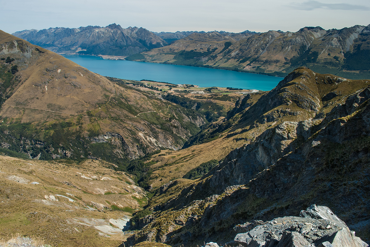
On the other side, the track wasted no time ascending Mt McIntosh. During water breaks I would divert my focus from the unending zig-zags by looking behind me. To the south-west, I was rewarded with panoramic views of Lake Wakatipu’s aquamarine glacial waters and the Humboldt Mountains rising from the opposite shore.
At 1200m, I reached the second junction. Nestled against the mountain not far above me was McIntyre Hut. This standard hut offers a good stopping point for anyone splitting the Lloop into a two-day trip. As I was tackling the track in a single day, I took the left-most fork and continued along the rocky ridge of Long Gully Saddle.
Past the saddle, the track entered a high-country station and became more gradual for a time. From here, views were unobstructed over the sweeping headwaters of Lake Wakatipu. The silty Rees and Dart Rivers embraced Mt Alfred/Ari, 1375m, beyond which lay the Routeburn, Beans and McBride Burns. Numerous 2000m summits were visible from this vantage point, including the snow-capped heights of Mt Earnslaw/Pikirakatahi, 2830m.
Just past the summit of the ridge, the track began its final steep descent over slick tufts of grass where hidden shallows can easily turn an ankle. I was grateful when the track met Chinaman’s Flat and I was able to stop watching my every step.
By the time I reached the Glenorchy-Queenstown Road, my thighs were aching and I was covered in sweat. Yet I was elated. In the course of a single day, the Mt McIntosh Loop had shown me a side of the region that most trampers bypass in favour of longer, more renowned tracks. I’d been able to experience one of New Zealand’s most incredible landscapes in almost total solitude – and still be back in time for supper.
– Lauren Buchholz


34 years of inspiring New Zealanders to explore the outdoors. Don’t miss out — subscribe today.

Questions? Contact us


