
A cold wade upstream in the morning sharpens us. Then, shortly beyond the hut, a Permolat tag marks the entrance to a creek. It’s overgrown – if it was ever clear – and we persevere to make progress through a leatherwood-choked tunnel in the streambed. We haul on the scrub, our hands slimy with the papery bark, and scramble up a small waterfall. Eventually, we leave the creek at the first sign of a clearing – just because it feels right – and it’s only when we look back that we see another Permolat strip marking the creek for people descending. These old aluminium track markers can mean everything and very little all at once; an ambiguous ‘this is the way but only if you can follow it long enough to find the next one’. It can take the intuition of a Jedi sometimes.
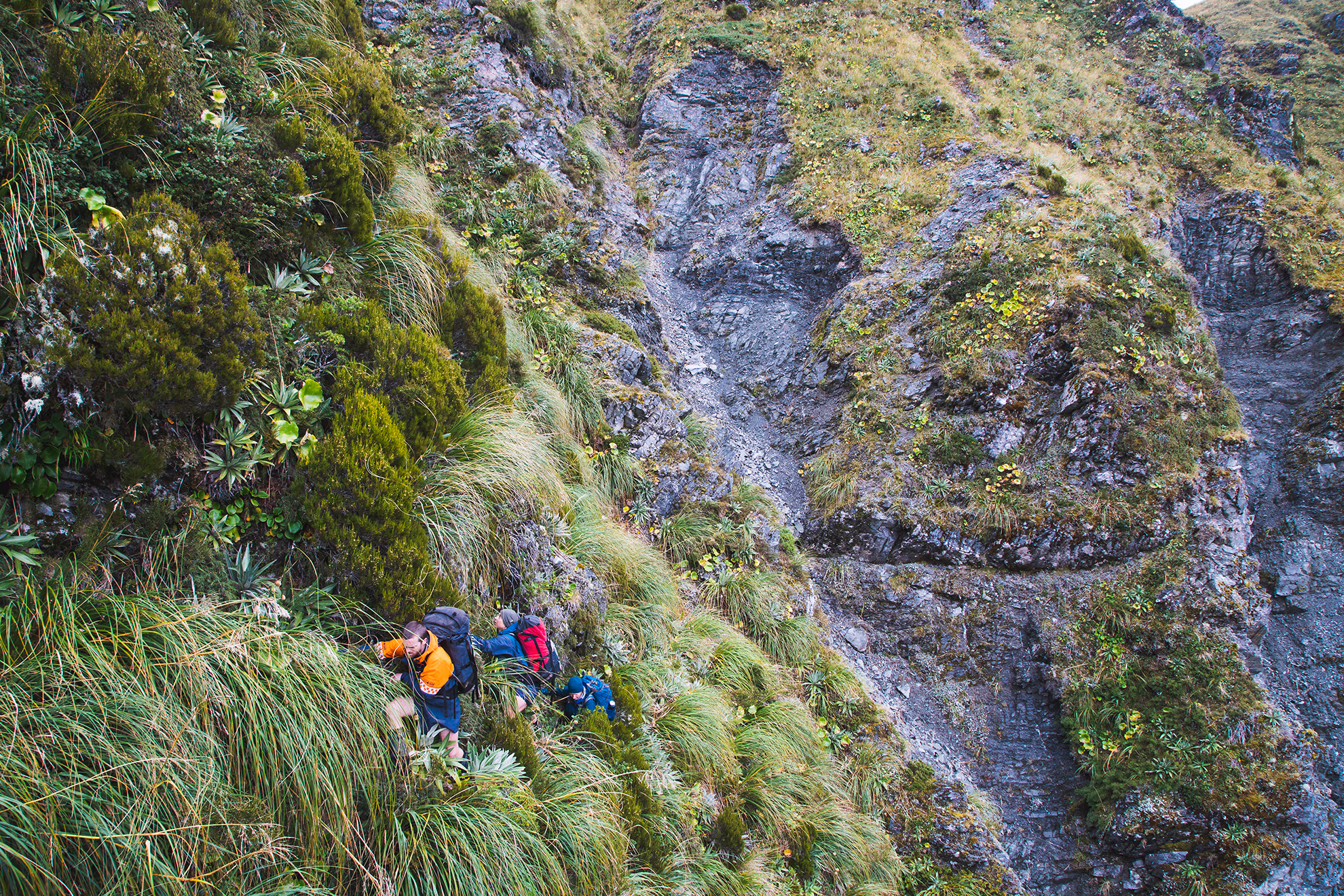
The intimate struggle continues as we climb to the ridge, often pulling ourselves up on plants. It’s almost a novelty to swing our legs again by the time we can walk freely along the ridge, and we make good progress towards the mist-shrouded summit of Mt Ross.
Inevitably, the rain returns, but we snatch a view into the upper Toaroha Valley. I recall a night and a morning spent there in the hut waiting out an electrical storm – the sort that brims every watercourse and leaves no alternative but to stay put.
We skirt below the top of Mt Ross to locate the ridge towards Toaroha Saddle. The route is not obvious, the terrain convoluted, but the convenience of GPS keeps us on track as we micro-navigate. Soon there’s only one way to go and we follow the ridge over small outcrops and delicately along narrows. It’s stunning tramping. It’s past lunchtime, but we are reluctant to stop in the wind and drizzle. I snack from my pockets as we push on to Toaroha Saddle Bivouac.
The bivvy fills with steam from our stoves as we scarf some food and warm up with hot drinks. The cloud base has lifted by the time we’re walking again, the rain has eased, and the views have opened up. Travel is easier on the broad ridge as we take the untracked tops route towards the Topo Creek descent to Mungo Hut, armed with a sparse but sufficient description from the Remote Huts website.
The hut is far below in its small clearing, made more obvious by a burn scar from an accidental and nearly disastrous scrub fire. We descend the crown of the ridge at first, marvelling at the exposure as steep slopes and stony gullies fall away on both sides. A rock step forces us onto those very slopes, and we can’t rejoin the ridge until after a careful descent down a loose gully and an exposed sidle left, the sort that has you grasping vegetation in both hands while your boots search for a solid footing.
Back on the ridge we descend further to where three old waratahs indicate the beginning of a several-hundred-metre plunge through steep scrub and stunted trees towards the valley floor. We descend carefully, clinging to dracophyllum trunks, sliding on gravel and being careful not to knock rocks down on each other. Shortly before the valley floor our head torches come out, and we eventually pick up the track from the riverbed to the hut.
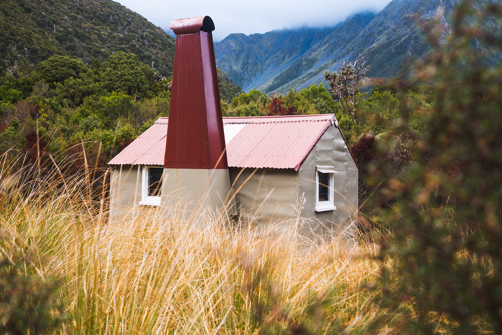
I’ve long wanted to visit Mungo. This humble four-bunker is the archetypal remote hut. It takes a few days to get there; its surroundings are pristine and awe-inspiring; and it’s largely faithful to its original 1962 construction. The current Mungo replaced the original, built on this site during the 1950s. Reaching the hut might be one of the goals for this trip, but there is so much else that’s intrinsic to tramping here that it doesn’t really matter that we’ve arrived after dark and will leave soon after daybreak. We shake sleeping bags onto the mattresses and break out the stoves. Scratched hands clutch cups as we reflect on the day over a hot drink.
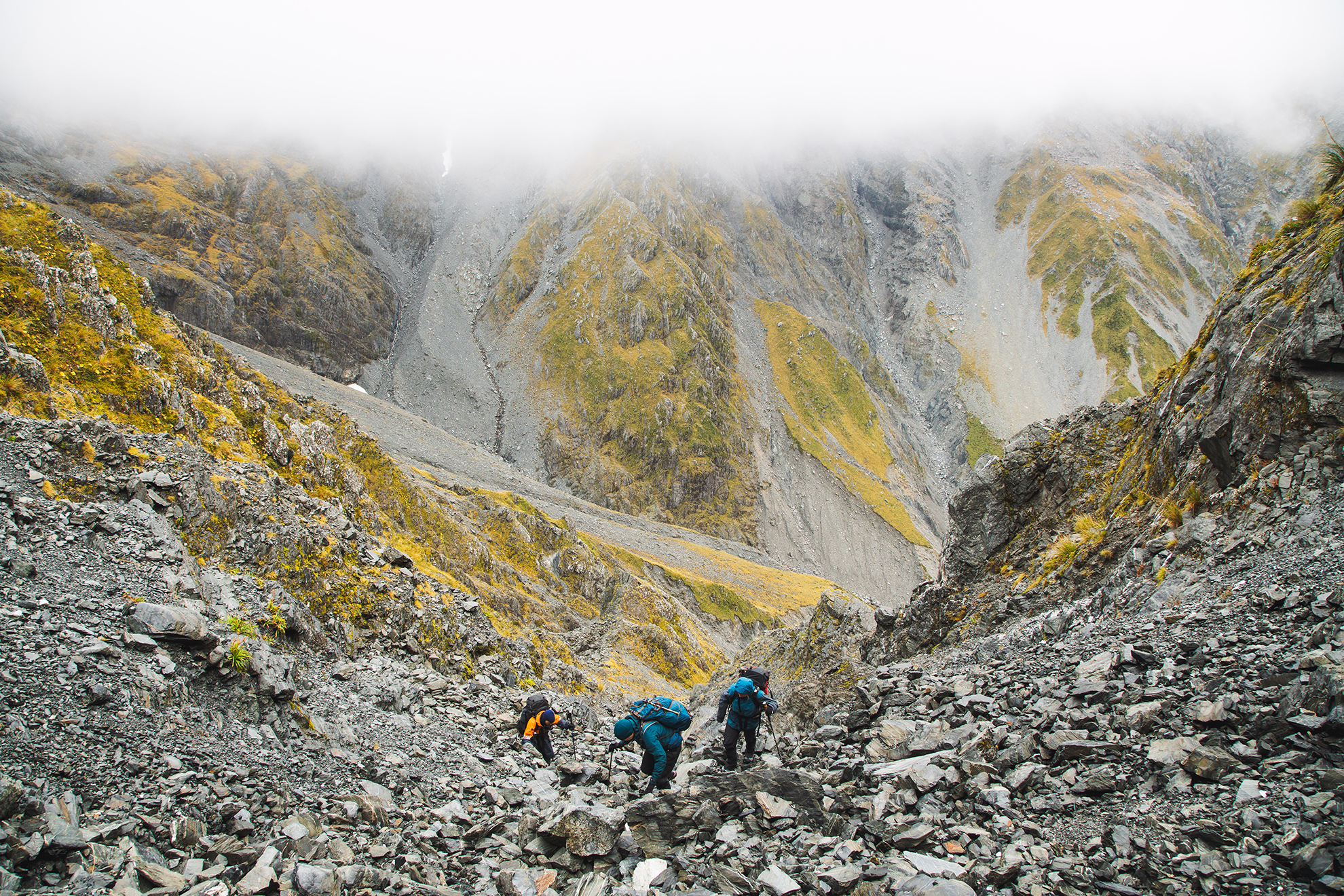
There’s no easy way out of the head of Park Stream. From the hut to here, the valley has been scoured by floods, leaving a wide bed of grey rubble. The walls around fade into the cloud that’s cloying the tops of the peaks that guard the cirque. Streams have riven millennia of gravel deposits to create deep gullies, and we’ll follow one of these to reach the ridgeline near Mt Chamberlain.
We climb 600 vertical metres, linking a gully with sections of scree and plants. It’s travel that requires a big-picture view as lines are sought to balance direct with secure. It’s a challenge I enjoy. Sometimes the steepest lines are the most stable as we work around loose or unfeasibly steep terrain. In places we regroup and discuss tackling the next section.
We’re already wearing overpants and shells in anticipation of conditions to come, and we’re grateful when we catch the force of the wind as we follow the ridge towards Mt Chamberlain. When the ridge becomes too steep to follow, we drop off to the west – to a respite from windblown rain – and sidle to a second col and a descent to the head of the Kokatahi River. Most of the time we’re in the cloud, and I reference the map on my phone to navigate.
The descent into the Kokatahi is a bit easier than the climb, and it feels good to reach the river. But travel’s slow in the rain as we negotiate around waterfalls, through scrub, small gullies and over and around boulders. Between the rain and the repeated wading in the river, we’re pretty wet when we make the final bash through scrub to the hut.
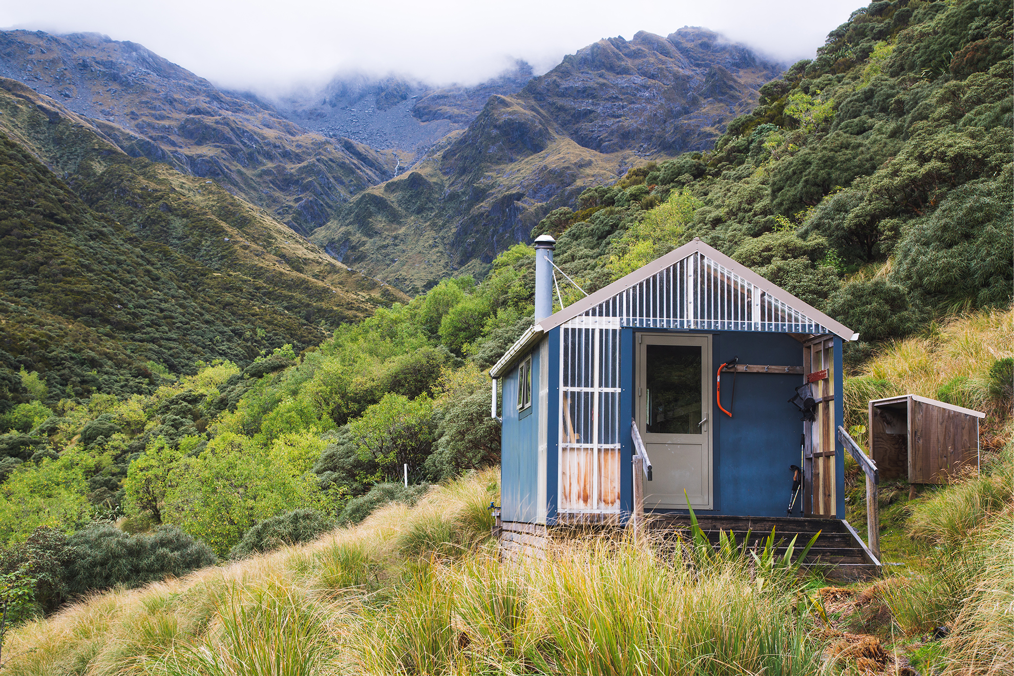
Top Kokatahi Hut is a sanctuary. We light the fire and hang clothes to dry as the rain increases. The next 12 hours are supposed to be the wettest of the trip, but we’re hoping the rain, and streams, will ease in time for us to walk the following day. The hut is soon like a sauna, and we relax and eat as rain pelts the roof, and the windows shudder with the wind.
We wake next morning to thunder echoing around the deep valley and flashes of lightning. A look out of the window reveals water coursing down every channel in the landscape. The Kokatahi River is churning and brown. Water’s flowing through the tussocks around the hut, and the steep gully route to Zit Saddle is flooded. Strong gusts of wind snatch the waterfalls and blow them sideways across the cliffs.
We’re going nowhere, so we settle into a well-earned pit morning and extra cups of tea. We’d anticipated this downtime and discuss climbing over Zit Saddle to Adventure Biv later that afternoon instead of right to Cedar Flat. Eleven o’clock rolls around, still raining, then noon. Although the rain eases later, the route up to Zit Saddle is impassable. We’ve resigned ourselves to a long walk out to the road end on our last day.
At about 5pm the rain stops, so, with stiff legs, I leave the foetid hut and wander around with my camera, observing, collecting firewood and breathing fresh air. The rain has renewed our surroundings and everything glows.
We leave the hut early next morning and make our way up the gully. It’s no longer awash with floodwaters and is quick travel, but we’re enveloped in a damp mist and can’t see much. Once out of the gully a few snow poles lead the way.
The inversion burns off as we cross tussock and colour slowly returns to our world. It’s the first sun we have seen in four days. The contrastless damp is soon forgotten as light and shadow bring the land to life amid swirling cloud. I scan the landscape to trace the route of the first two days.
I know what’s coming, I’ve been there before: a steep and scrappy downhill, some head-high scrub, Adventure Biv and then a knee-testing drop way down to the river.
Finally, from Cedar Flat, all that remains is a four hour march to the road end. What had flown by with the fresh-footedness and anticipation of day one seems to take twice as long now. I didn’t wish it over, though, despite the aches of a few days’ tramping, because I didn’t really want to leave so soon.


