


Shaun Barnett makes a winter crossing of this unnamed pass in Nelson Lakes
New Zealand mountain weather. Changeable, dramatic, unpredictable. How many hours do trampers devote to debating the weather?
We all hope for a good forecast. Plan-A, game on.
An atrocious forecast is almost as easy to deal with: stay at home or change to Plan-B.
But a marginal report always proves harder. What tricks will the mountain weather conjure?
Three of us – Peter Laurenson, Darryn Pegram and I – had abandoned our Plan-A for climbing at Arthur’s Pass, and with better weather forecast for Nelson Lakes, settled on Plan-B: head up the Travers Valley and climb Mt Travers if conditions allowed. If not, then we’d have the consolation of tramping the Travers-Sabine Circuit. It seemed a reasonable strategy.
The tramp to John Tait Hut crosses the easy terrain of a valley ploughed by past glaciers, but carrying a week’s worth of food and climbing gear, it took us five hours of trudging. Rope, harnesses, helmets and snow-stakes all added up to mean loads. Peter’s knee complained, and he suffered most of the way.
In winter, and with the New Zealand border closed to overseas hikers, John Tait Hut proved quiet so we spread out luxuriously. However, high cloud and intermittent drizzle meant indecision gnawed away at us. What to do? Climb or tramp? And if we tramped, we still had all this climbing gear to carry.
In the end, I suggested we try the Summit Creek route on Travers, which begins near the hut. As the easiest route on the mountain, it might yield in less-than-ideal conditions.
We rose early to stare skyward. It wasn’t raining, but neither were there any stars. Under torchlight, we headed up-valley, and soon reached the footbridge over Summit Creek. There, we were pleasantly surprised to find a well-used route through the forest on the true left of the creek. As the dawn light gathered, we reached the long upper basin of Summit Creek, flanked by mountainsides frowning under heavy brows of cloud. Mt Travers remained hidden.
Pushing through drizzled-soaked tussocks and speargrass, and avoiding holes, we climbed onto the northern side of the mountain. Cliffs disappeared into obscuring mist, but using his phone Darryn navigated us into the correct gully, beneath a great prow. Warmer conditions had melted any recent snow, so, instead of cramponing, we found ourselves clawing up loose scree; two steps up, one step down – and sometimes worse. So much for winter.
After four hours, we’d ascended close to 900m. The summit would need another three. Time ticked away, and so did my resolve.
As the drizzle began to get heavier, we paused, awkward on the steepening slope. Visibility was about 50m. I peered into the murk, willing it to lift.
“I don’t know about you guys,” I said, “but this isn’t great.”
This was Peter’s third attempt on Travers in recent years, but to my surprise he agreed to abandon the climb immediately.
“Yeah, we’re moving pretty slow and even if we made the summit, we’d probably be descending in the dark.”
Darryn was happy enough to go with the flow. And downhill was definitely better flow.
Once off the scree, a boulder overhang provided some semblance of shelter from the dripping sky and we ate a subdued lunch. “Better than working,” I quipped, but my mates seemed muted.
Back at John Tait Hut, I sawed pine while Darryn cooked dinner and Peter lit the wood-burner. A solo hiker arrived, having crossed Travers Saddle in deep snow. We queried her about the conditions. What should we do? Once again, indecision gnawed at us. I could tell that Peter, always hankering for the high ground, was particularly disappointed with the failed climb.
It looked like we might get one reasonable day, so I suggested Gunsight Pass might make a good consolation prize. We could leave excess gear and food at John Tait, tramp with light packs up to Cupola Basin and cross this high-level route to Upper Travers through the Gunsight. Plan-C, or was it Plan-D, was on.
The track to Cupola Basin is a delight; climbing gently at first, then zigzagging through mountain beech forest, wispy with lichens. Tomtits trilled their squeaky wheelbarrow songs. As we emerged above the bushline, Mt Hopeless was clear, but clouds hid Cupola.
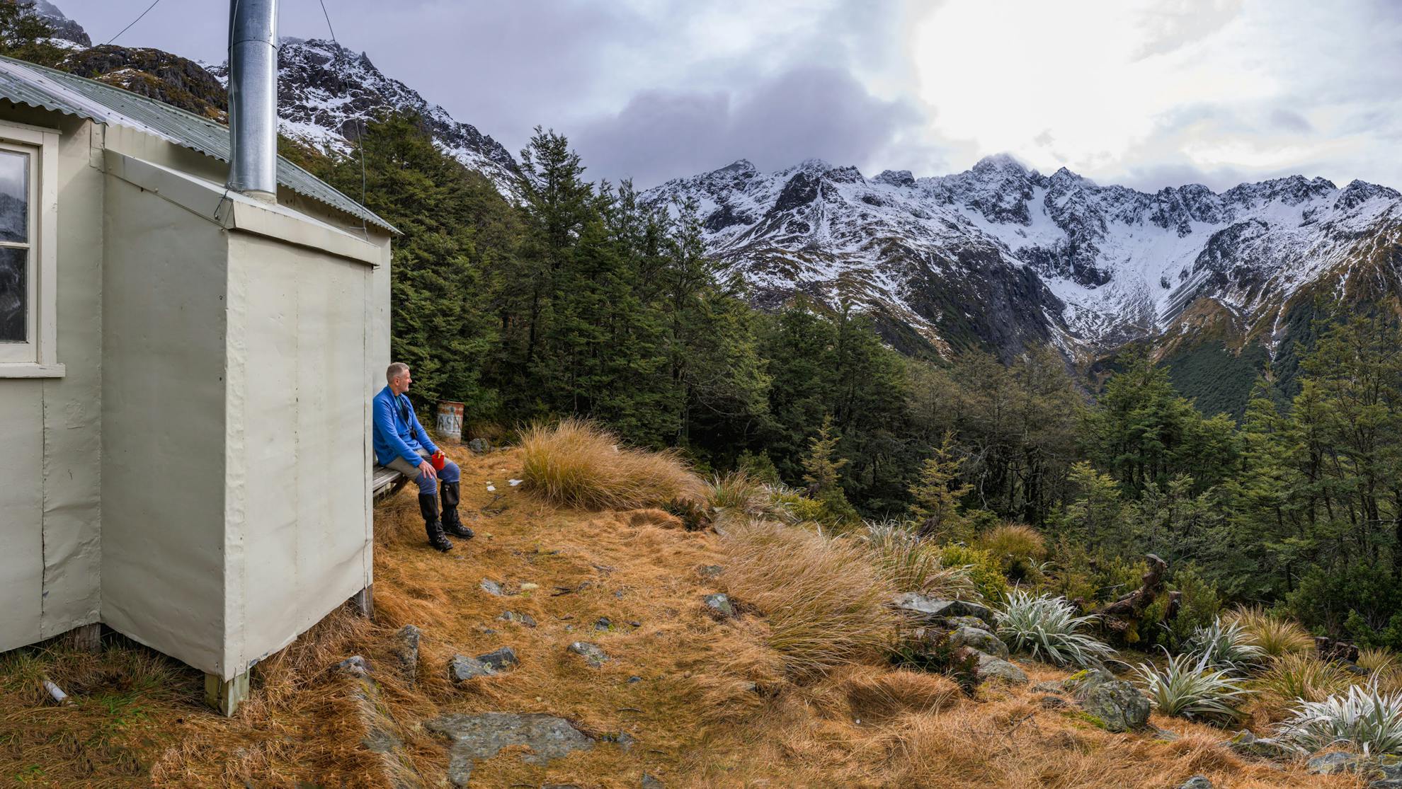
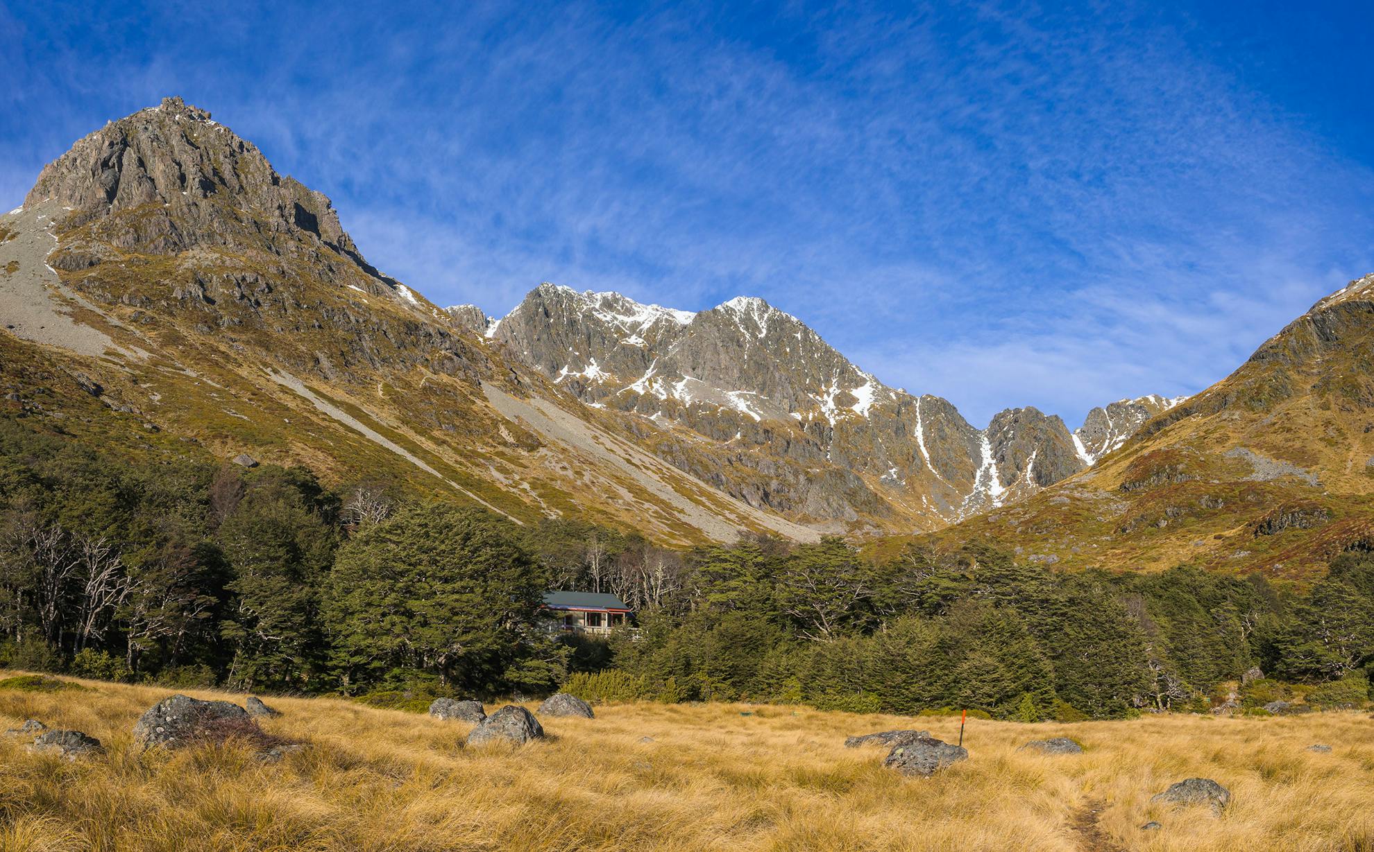
Once a base for animal research, Cupola Hut is different from other backcountry shelters. Stories of scientists chasing down deer fawns with butterfly nets, tagging grasshoppers and recording the bird and plant life are an integral part of the hut’s history. After the research ended in the 1970s, my friend Bruce Postill, who was a park ranger at the time, converted it into a tramper’s hut – including installing a wood-burner. A fire certainly added to the hut’s cosiness.
The hut lies just on the bushline, beneath perhaps the most appealing alpine basin in the whole national park.
As dawn broke, we were above the hut, pack-clad and moving across its tussocky shelves. A small frozen tarn reflected blue shadows among the golden grasses, and the sunless basin was cold in the winter air. Above rose the huge domed form of Cupola, one of the highest mountains in Nelson Lakes National Park, cloud-capped, its black cliffs wet and ominous. We’d half entertained thoughts of climbing it, but the cloud persisted. Instead, we turned our full attention towards the distinctive notch in the ridge ahead: Gunsight Pass.
Staring up the barrel of the basin, the U-shaped pass looks almost as if it was carved mechanically. Locals have long known it as Gunsight Pass, even if it remains nameless on the maps. A decade before, Darryn and I had crossed it in the opposite direction, inspired after reading about it in Ben Winnubst’s climbing guidebook Kaikoura–Kahurangi.
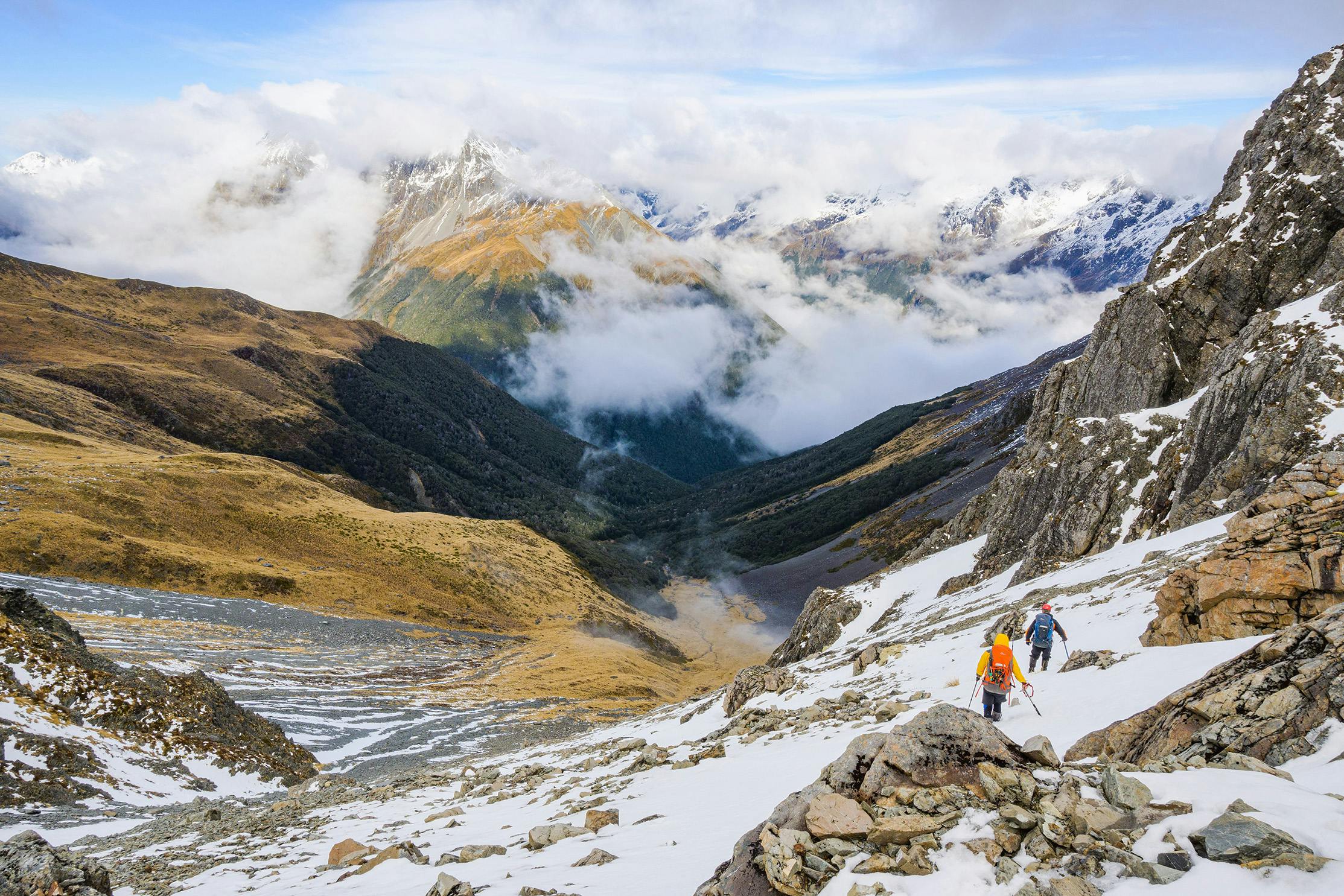
A small drop, followed by a climb, led to a shelf beneath the pass, where the final approach steepened. The soft sugary snow proved hard work to plug through, but soon enough we were in the Gunsight, at 1790m. I relish that moment just before you crest the heights, when a fresh view awaits. You straddle the edge between two vistas, seemingly between two worlds. No pass is the same on both sides.

Cloud swirled over the Franklin Ridge and Sabine Valley, and the scene had a curiously sharp wintry quality to it – the visibility crisp and clear, and the cushion plants etched among the lichened rocks.
Our high sidling route lay before us. Peter later accurately dubbed it ‘three passes’ and, unmarked even by cairns, it requires some navigational nous. Below Gunsight Pass (Pass 1), it descends a chute, then sidles beneath ribs, across tussock and rock slopes, past a dome-like lump of rock, and up to another saddle at 1800m (Pass 2). This is a painful but necessary climb to avoid steep terrain on the far side. It’s a crying shame that you can’t tramp directly through the lovely tussock basin, complete with tarns, which beckons below.
We had lunch on a ledge, watching the wreathing cloud, before tackling the climb to 1800m. Darryn and I were surprised to find that in this direction, the terrain had small traps – little bluffs too small to show up on the map – and a couple of times we had to detour to avoid small drops. I bungled the navigation at one point, forcing us to escape a bluff line by entering a steep gully, which earned us all cuts and bruises.
Finally, the route crosses a large boulder field before intercepting the Travers Saddle track just above the bushline. By now we were tired, but still had to face the climb over Travers Saddle – nearly 400m. Deep snow over the pass hid many holes, and it was hard to fully appreciate the scenery as we slogged our way over. The tarn beneath Mt Travers lay frozen and snow-covered, only a flat, slightly bluer area to indicate its position. With Pass 3 behind us, and after some 10 hours on the move, we were relieved to reach the snow-free, flat ground of the Upper Travers Valley. A short while later we reached the hut.
After a big day, cooking dinner is a big effort, but Darryn generously obliged, serving up a three-course feast of Miso soup, dahl and rice, followed by chocolate mousse. In the night, groans accompanied all but the slightest movements as our bodies protested at the gymnastics they’d been put through. At least we’re still out here doing it, I consoled myself.
Sunrise lit the sharp form of Mt Travers in the morning, and Peter pointed out the route of his previous attempt. A flock of pīpipi, or brown creepers, chittered in the forest, and the dead flowers of last season’s mountain daisies protruded among the tussock, Astelia and snow tōtara. It was our first and last completely fine day, and the irony was not lost on us as we headed out, down the Travers Valley.
Beginning beside the burbling streams of the Upper Travers, the track gradually descends through the beech forest to Summit Creek, and on to John Tait Hut, where we lingered for a pleasant hour over lunch. Back on familiar ground, we enjoyed a lovely, lazy, easy walk down the valley flats, chatting about life and careers. It was beautifully warm – almost summery – until dusk.
We reached Lakehead Hut just as evening cloud gathered on the mountaintops and wood smoke began to curl from the chimney. A weka called, harsh in the still air.
At the hut were two women, both tramping separately. Annabel was the younger of the two, a landscape architect student and keen card player. That night we played several rounds of ‘Presidents and Arseholes’, and as we did, the older woman, Muriel, told us stories of a remarkable life.
As a child, she had helped build John Tait Hut, as her parents knew John Tait. She’d mustered cattle in the valley before it became a national park, helping the researchers at Cupola Basin, knew ranger George Lyon, and later worked in Alaska before embarking on a law degree at Cambridge University and a career as an international relations lawyer. These days, she lives on a farm in the North Island, but comes back regularly to Nelson and Marlborough to enjoy the places of her youth.
Darryn, Peter and I all agreed Muriel was fascinating, but Annabel seemed curiously reluctant to engage in any conversation with her.
In the morning I asked Muriel if she would be willing for me to write an article about her. “I’m flattered,” she replied. “But, no, I will have to decline, as my international law work means I have to keep my identity discrete.”
We farewelled Annabel and Muriel and departed for St Arnaud on the track beside Lake Rotoiti. Walking often encourages thinking, and I began mulling the evening over. Feeling horribly uncharitable, I mentioned to Darryn, “You know, Muriel’s timeline doesn’t add up. John Tait Hut was built in the 1940s, and she can’t be that old. And how come she seemed to be involved in every major development of the national park?”
Darryn chimed in with his doubts too. “Why couldn’t she explain what her PhD topic was?”
“Yeah,” added Peter. “And if she’s an international lawyer, how come she was so crap at playing cards?”
Maybe Muriel had played us for fools with her fabulous fibs, just like the forecast.
- Distance
- 65km
- Total Ascent
- 3029m
- Grade
- Difficult
- Time
- Lakehead Hut to John Tait Hut, 4-5hr; to Cupola Hut, 3hr; to Upper Travers Hut via Gunsight Pass 8-10hr; To John Tait Hut, 3hr; to St Arnaud 2.5-3hr
- Accom.
- Lakehead Hut (28 bunks), John Tait Hut (27 bunks), Cupola Hut (eight bunks), Upper Travers Hut (24 bunks)
- Access
- From St Arnaud on Lakehead Track or via water taxi to Lakehead Hut
- Map
- BR24, BS24
GPX File
- Gunsight Pass (gpx, 52 KB)
GPX File
- Your device does not support GPX files. Please try a different device.
