


Aotea/Great Barrier Island is a paradise for hikers and mountain bikers, writes Dave Mitchell
Aotea lies at the outer reaches of the 1.2m/ha Hauraki Gulf Marine Park. A map of the Island reveals two very important things: there are no straight roads and little flat land amongst the bush-clad corrugations.
Surprisingly, there are no hungry possums, stoats, weasels, ferrets, hedgehogs, deer, wallabies or goats. But it does have a varied and long history, dating back more than 800 years when Māori settled the island.
Whaling began in the 1790s, copper was discovered in the 1840s and gold and silver in the 1890s, but it was the logging of the massive kauri forests between 1880 and 1930 that changed the landscape forever.
In 2017, it became one of just four locations (and the first island) awarded with Dark Sky Sanctuary status.
The island has an incredibly long coastline with numerous bays, inlets and headlands making it a boaties paradise. But, with much of the island protected in some form of park or reserve, it’s also a playground for trampers and bikers, as these three trails attest.
Forest Road and Te Ahumata Track
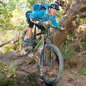
From Port Fitzroy and the beautiful DOC campsite in Kaiaraara Bay, the Forest Road mountain bike track begins. It’s really just an old logging road that wanders through Aotea Conservation Park, built when kauri extraction was in full swing.
The trail initially leads to Kaiaraara Hut, now passing through a mix of pine and gum trees, with regenerating natives in-between. From the hut, native regeneration dominates and there are many young kauri growing through the ferns and low broadleaf canopy.
The trail climbs around the western side of Mt Young to reach stands of mature kauri and then passes a few massive individuals that were somehow spared the axe.
DOC has done everything to protect these trees from kauri dieback, with barriers and hardened trails to prevent people getting too close.
The ride continues to the high point around the north face of Maungapiko (280m), with views out to the Broken Islands and across to the mainland on clear days. Rocky outcrops and a sea of young kauri roam the high country beneath The Hogs Back and it’s possible to imagine what it must have been like before the logging commenced.
The undulating trail ends on a long downhill to Whangaparapara Road and the start of a benched mining track just past the site of the Orville stamping battery. This ascends to just below Te Ahumata (398m) and skirts its northern aspect to then descend the eastern side to Blind Bay Road. There are a few steps along the way to negotiate and amazing views to the golden sand of Kaitoke Beach and a row of tiny islands bobbing off the coast.
If camping another night at Kaiaraara Bay, head back the way you came – clocking up an impressive round trip.
Grade 2-3
Distance 18.2km each way
Time 4-6hr

Harataonga Walkway
The Harataonga Walkway lies on the eastern side of the island, directly opposite Port Fitzroy. This walkway was once the main access route along the coast. Cut as a pack track on a nice gradient, it has been recycled as an excellent walking and mountain biking trail. With great views along the rugged coastline, it climbs high above the high tide mark through a corridor of kānuka and broadleaf, nīkau and fern with glimpses of hidden bays and sandy beaches along the way.
Eventually, the trail rounds the headland at the massive Whangapoua Creek Inlet protected by the long finger of sandy Whangapoua Beach. The tidal inlet stretches back to a salty wetland of rushes and reeds. The trail pops out onto Aotea Road, about 3km from Okiwi.
Grade 2
Distance 11.6km each way
Time 3-5hr
Kowhai Valley Track
The DOC camp at Medlands Beach provides a base for exploring the Kowhai Valley Track. Medlands is a long sandy beach with rocky headlands and a small stream estuary that, at low tide, enters the bay, flushing brackish warm water back into the sea.
The ride begins by crossing the creek at the beach’s southern end to access a steep benched single track. This climbs through an old farm and along random fence-lines in various states of disrepair. Switch-backs have been installed to alleviate the gradient but the trail-top only arrives after the steepest section.
It’s a fun downhill out to Rosalie Bay Road where it’s possible to park the bikes and hike up Station Rock lookout. Here, there are views in all directions – from the town of Tryphena below to the Coromandel Peninsula to the east.
Our return ride thankfully had way more downhill, ending with a lazy afternoon packing up the gear and getting ready for the reluctant morning exit back to Auckland. All good things must come to an end, they say. The island had flown under our radar for years but proved to be a great MTB destination and, with its amazing tramping tracks, you could easily indulge a couple of weeks or maybe three, making the trip over all the more worthwhile.
Grade 3
Distance 11.6km each way
Time 2-4hr
