The Whanahuia Range, part of the 95,000ha Ruahine Forest Park, is a western outlier of tussock tops connected to the main Ruahine Range by the peak of Te Hekenga. Spanning about 12km, the broad range is bordered by the Pourangaki River to the north and the Oroua River to the south and east. Tramping and hunting are the main outdoor pursuits, but the flat, rolling tops offer scope for winter ski-touring and snow-boarding. Trout fishing is popular in both rivers.
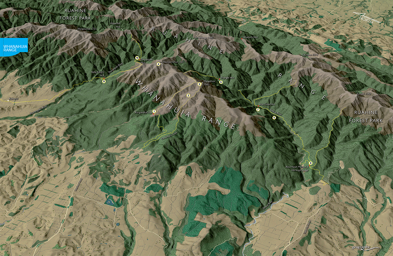
1 Rangiwahia Hut
Easiest access onto the tops of the Whanahuia Range is on the track to Rangiwahia Hut, which takes about 2-3hr from Renfrew Road car park. Aside from a steepish detour around a slip (DOC is cutting another track around it), the track is nicely benched. The 12-bunk hut (built in 1983-84) is the successor to at least three previous versions, two associated with clubs: the Rangiwahia Ski Club and the Palmerston North Tramping and Mountaineering Club (PMTMC). Beyond the hut, a poled route leads onto the crest of the Whanahuia Range.
2 Deadmans Track
This alternative track to the Whanahuia tops starts from Renfrew Road car park and reaches the range crest at Mangahuia. Allow 5-6hr from Renfrew Road to Rangiwahia Hut, via Mangahuia.
3 Mangahuia
Mangahuia (1583m) offers good views over the main Ruahine Range, Mt Ruapehu and westwards to Rangitikei farmland. A poled route leads north, then east into the headwaters of the Oroua River.
4 Maungamahue
Maungamahue (1661m) is the highest peak on the Whanahuia Range and also marks the point where a ridge connects the range with the main Ruahine Range. Experienced trampers occasionally use this route to reach Howletts Hut, traversing Te Hekenga en route. A narrow ‘cheval’ section on this ridge offers an exposed challenge, but can be avoided by a lower sidle on an obvious deer trail. The ridge’s difficulty ensured it was not traversed until as late as the 1930s.
5 Triangle Hut
I’d always imagined this hut as an A-frame, like two others in the Ruahine’s, but it is in fact a standard six-bunk NZFS-built hut, with a veranda. Situated on the banks of the Oroua River, it’s a pleasant spot overlooking the bush.
6 Oroua River
Travel down the Oroua River from Triangle is straightforward until the river swings eastwards through a tight gorge. A track that climbs sharply over a ridge avoids the gorge and re-enters the river a short distance upstream from Iron Gate Hut.
7 Iron Gate Hut
A seven-bunk hut on a pleasant river terrace in the middle reaches of the Oroua. This is blue duck country and the native birds have a fighting chance of survival thanks to a stoat-trapping programme, run by the PNTMC and the NZ Deerstalkers Association. Allow 4-5hr to reach the hut from Table Flat Road, or 2-3hr from Triangle Hut. Beware of fording side creeks during rain, as they can rise suddenly.
8 Alice Nash Memorial Heritage Lodge
After the original Heritage Lodge burnt down in 2005, members of the NZDA Manawatu Branch built this spacious eight-bunk hut using a bequest from Alice Nash. It was opened in 2007. It’s only 40-60min from Table Flat road end and is ideal for family groups or novice trampers. Nearby, a track leads to good campsites near the Oroua River. From the hut, another easy track climbs gently to the dominant peak of Tunupo, on the Ngamoko Range.
9 Kelly Knight Hut
This eight-bunk hut makes a good weekend destination for novice trampers. Permission from Kohunui Station (P: 06 382 5577) should be gained to cross the land from the Mangakukeke Road car park. Access is closed during the spring calving season. From the farm boundary, a well-benched track leads up-valley through beech forest, before dropping to cross a swingbridge over the Pourangaki River to reach the hut. Allow 3-4hr.