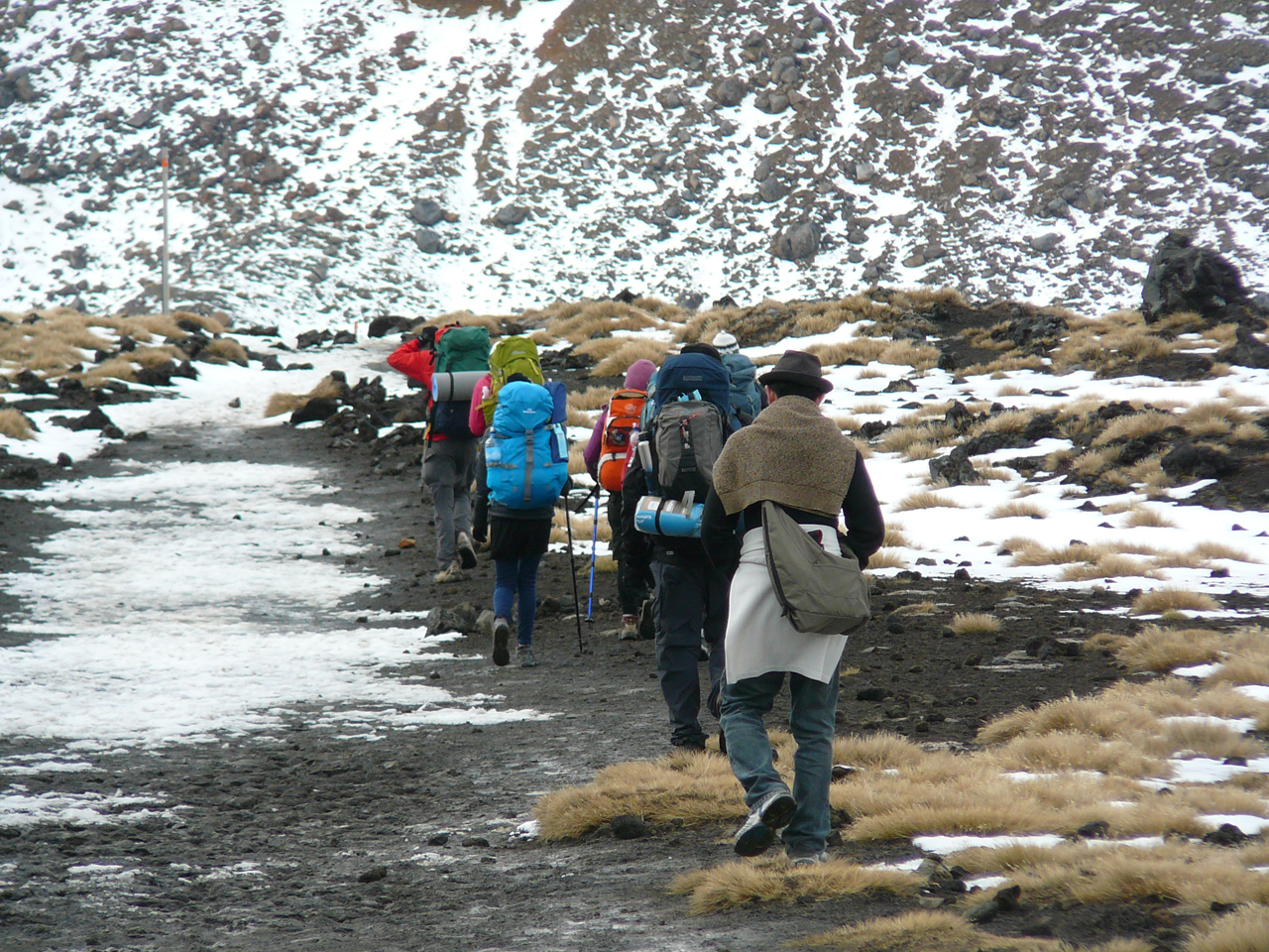
People planning to walk the Tongariro Alpine Crossing should leave their jeans and Chucks at home or face finding their own way to the track start, thanks to new safety rules adopted by DOC.
The new rules have come out of a an incident last month when a shuttle operator allowed 16 inexperienced and poorly attired trampers to attempt the TAC in the face of dangerous weather conditions. By the time the group reached the summit of Tongariro they were soaked to the skin with many of them in the early stages of hypothermia.
At the time, Tongariro Alpine Crossing Transport and Guide concessionaires group (TACTAG) chairman Stu Barclay told Wilderness the concessionaires group and DOC would be working out how to prevent this from happening again and to ensure there are real consequences for operators who let such situations eventuate.
Despite efforts to make people aware the TAC passes through an unpredictable and dangerous alpine environment, hundreds of visitors do the 19km tramp in street wear like jeans, sneakers, mini-skirts and, unbelievably, even high heels.
This attire may fit the bill when ascending Queen Street, but doesn’t leave much between the wearer and death when the weather folds at 1800m.
It seems everyone has had enough of this, because at a meeting this week between TACTAG, police and DOC, it was decided operators holding concessions for guiding and transport services for the crossing to be TACTAG members and to abide by its protocols.
TACTAG has established protocols that guide operators on weather conditions and the minimum equipment for trampers. Group members have agreed to operate to these protocols, meaning they will not transport trampers to the crossing if the weather is unsuitable or walkers do not have appropriate clothing and equipment.
Barclay said the group has a 12 month goal to have all TAC transport and guiding concessionaires signed up as members.
“We plan to revisit the group’s safety procedures and protocols to ensure we are not simply meeting existing legal needs but setting a standard of operation above this to a level where we are confident we are meeting our moral and professional responsibilities,” said Barclay, who added that failure to follow the protocols might lead to a loss of concession.
Ruapehu area police commander inspector Steve Mastrovich said Police endorse the decisions made at the meeting, particularly the move to require concessionaires to belong to TACTAG.
“We believe this will empower the operators to apply consistent practices on the crossing,” he said.
– Josh Gale

A community group trying to build a three-day loop track from Turangi to Tree Trunk Gorge has achieved a small victory, but faces a long delay before the trail’s entirety can be realised.
After five years of work, the Advocates for the Tongariro River have finally been cleared to build new sections of track from Red Hut car park to Turangi on the true left of Tongariro River.
Walkers and cyclists can currently take the Tongariro River Walkway on the true right of the river to as far as Blue Pool, but have to return the same way.
Advocates chairman Eric Wilson said the new section will create a 20km loop track that passes through many scenic spots popular with anglers.
Estimated to cost $100,000, the new track will include two bridges to cross streams and a boardwalk to cross a swamp. Wilson hopes it will be ready by Labour Weekend for an official opening.
While the Tongariro River Walkway follows the river bank, the new sections will pass through roads that board reserve land close to SH1. Wilson said this is to avoid using private land on the river’s edge.
The group’s long term vision of creating a three-day Tongariro River Trail running from Turangi up the right side of Tongariro River to Tree Trunk Gorge and back down the river’s true left to Turangi remains a distant dream because of unresolved ownership and access issues, Wilson said.
Much of the land around the Whitikau River is owned by the government and used by Rangipo prison but local Maori have a Treaty of Waitangi claim on the land.
“The dream of turning it into a three day track seems to be as far away as it ever was,” said Wilson.

More than 16,300 people have signed a petition demanding the Milford tunnel project be scrapped.
The petition is against the proposed private bus tunnel through the Fiordland and Mt Aspiring National Parks which tourism operators fear will destroy the country’s ‘100% Pure’ brand.
Tourism operators – as well as domestic and overseas tourists – have joined the protest, warning that one of the world’s last great wilderness destinations will be ruined by the construction of an underground bus tunnel through the area.
A private company plans to build an 11.3km bus tunnel in New Zealand’s Fiordland and Mt Aspiring National Parks, both situated in the Te Wahipounamu World Heritage Area. The tunnel would be for the exclusive use of buses to take tourists from Queenstown to Milford Sound.
Tourism groups believe the World Heritage status of the region is under threat because of the project and have joined a growing online protest aimed at halting the development.
Glenorchy resident Patricia Ko started the petition on the website change.org. It is now the largest New Zealand petition hosted by the website. Each time the petition is signed, an email is sent to Conservation Minister Kate Wilkinson, who has the final decision on the project.
Ko said the Milford Dart tunnel project was putting New Zealand’s 100% Pure brand at risk. “Putting a bus tunnel through this world heritage area would make a lie of New Zealand’s clean and green image overseas,” she said. “I can’t believe that the government might jeopardise New Zealand’s most valuable and precious natural tourist destination, and destroy our communities at the same time.”
The Department of Conservation has given notice of intention to grant permission for the tunnel, but the final decision rests with the Conservation Minister, who has admitted the topic is “very controversial”.

The Wellington branch of the New Zealand Deerstalkers has backed member Tony Macklin to save Cattle Ridge Hut in Tararua Forest Park.
Macklin is a Wellington architect and was the project manager for the restoration of Roaring Stag Hut which lies at the bottom of a ridge below Cattle Ridge Hut.
A fellow branch member and builder who helped Macklin repair Roaring Stag Hut has also come on board again to repair Cattle Ridge Hut.
Macklin is working on a management and restoration plan so the branch can take over the maintenance of the 51-year-old ex-Forest Service hut from DOC.
For DOC to give approval, Macklin must complete a business plan that proves the branch is able to fund the maintenance and restoration of the hut.
Considerable repair work needs to be done to bring the hut up to DOC’s safety requirements.
Macklin said the restoration will include a new tin roof, new framing where required, three new double-glazed windows, new interior lining plus the foundations may need repairing.
Macklin is trying to keep costs at about $30,000.
“I know others want the hut restored in its present condition, and so do I, but if the cost goes above about $50,000 then it’s actually cheaper to pull the hut out and fly in a new five man hut,” Macklin said. “It’s not really what others want, but we’ve got to look at the best logistical way of doing it.
“I don’t think we’re going to get up to that sort of price range, but you never know.”
Carterton teacher and tramper Joe Nawalaniec started the Save Cattle Ridge Hut campaign when he heard DOC was considering removing the hut.
Nawalaniec has “surveyed the hut” and believes it shouldn’t be removed even to make way for a new building.
“It is a finely-crafted, iconic example of a mountain hut, from another era and accessible examples of this style of hut in the Tararuas are dwindling,” he said. “Replacing this hut would be very wasteful, both in terms of conservation history and in terms of use of resources.”
Macklin would also prefer to keep the current hut, but said he has to consider what’s best for Wellington Deerstalkers.
“I see Wellington branch having to bankroll the whole thing, but hopefully we can get a bit of money out of a couple of charities and businesses to offset our investment,” he said.
Macklin is visiting the hut in the coming weeks and will make a final decision about whether to repair or replace it after that.
Wilderness magazine has teamed up with leading smartphone GPS app provider ViewRanger to allow users of ViewRanger’s digital mapping app to download the routes and trips published in each issue of the magazine.
From this issue onwards, readers will notice a ViewRanger icon and route code printed on the ‘Wild Trip’ pages. This indicates routes available for download at www.viewranger.com/wilderness or direct to your smartphone once you’ve installed the app – simply follow the on-screen menu and search for routes or key in the unique ‘Wldrnss’ shortcode published in the magazine and hit download. You’ll get all the info – mapped trail and route notes – installed onto your phone. When you’ve reached the start of the track, open the route and hit follow navigation, you’ll see your mapped location on screen and get alerts when you reach each waypoint.
As well as letting you download and navigate Wilderness trips, ViewRanger shows your GPS location on the map, records a track of your adventures, views and captures a wide range of stats liked distance travelled, speed and height gain/loss. You can even share your location with others using BuddyBeacon. There’s also a web service at my.viewranger.com that synchronises to the app so you can create routes on your PC or use the social network tools to share your trips with your friends or publish to the community.
The app is free to install on Apple iPhones, iPads, Android devices and Symbian smartphones from Nokia and Sony Ericsson and comes with access to global web maps like OpenStreetMap that can be stored on the phone, so it will work even without a mobile signal. Users can then add detailed LINZ Topo50 maps from just $2.59, using in-app purchasing.
Readers who don’t have a ViewRanger-compatible smartphone can continue to download trail routes to their PC or GPS device at wildernessstg.mystagingwebsite.com.

Dr Nigel Kim of Tauranga was convicted in the Tauranga District Court on May 24 and ordered by a judge to pay a $1000 fine for a hunting offence he committed in the Kaimai/Mamaku Forest Park.
Kim was convicted under the Conservation Act for breaching the conditions of his hunting permit by hunting at night near a busy hut and camping site.
The incident occurred on the evening of August 20 last year when Kim, using a torch to see, fired his crossbow at a possum. The crossbow bolt embedded in a tree trunk near a tent where members of a Mountain Safety Council youth group were sleeping.
The bolt was discovered the next morning and resulted in two separate public complaints being lodged with DOC.
DOC Tauranga area biodiversity programme manager Chris Clark said shooting in low light conditions close to a hut and tents was highly irresponsible and dangerous.
Hunting in darkness is totally prohibited on public conservation land because of the danger it poses to the public.
“It is particularly reckless when carried out close to camping areas where people are likely to be,” said Clark. “Fortunately no one was harmed as a result of the incident.
“This case should serve as an example that if hunters don’t adhere to the conditions of their permit and put people at risk, DOC will take action against them.”
DOC acknowledges that most hunters are responsible and encourages them to follow the arms code guidelines and DOC permit conditions when hunting on public conservation land.

34 years of inspiring New Zealanders to explore the outdoors. Don’t miss out — subscribe today.

Questions? Contact us