Image of the June 2012 Wilderness Magazine Cover Read more from the
June 2012 Issue
Home / Articles / Waypoints

Top 3 glacier hikes

An aerial view of the Fox Glacier. Westland National Park. Photo: Derek Morrison
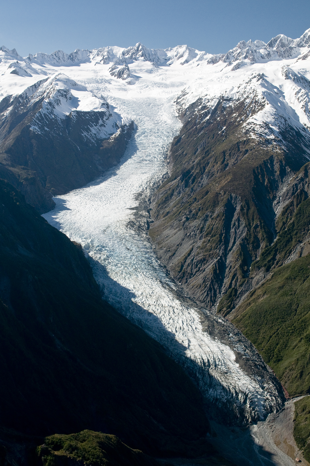
There are 3161 glaciers larger than one hectare in New Zealand. Of those, all but six are in the South Island, with Ruapehu clutching the handful in the north. Each of them is a place of stunning beauty and a display of unimaginable power played out in ultra slow motion. By Derek Morrison

Fox Glacier, Westland

Fox Glacier, or Te Moeka o Tuawe, is one of the world’s most loved glaciers – and one of the most accessible.

Twenty-three kilometres south of Franz Josef Glacier on the West Coast, Fox Glacier is one of the few glaciers in the world that descends into rainforest just 300m above sea-level.

The terminal face is 2.6km from the car park at the end of the glacier access road. This is the experience that most of the estimated 1000 tourists each day have with the glacier. But its accessibility belies the seriousness of this glacier. In 2009 two Australian tourists were crushed to death by 100 tonnes of ice after crossing barriers at the terminal face.

Stepping onto the 13km-long glacier is best done with a local guide who knows the pace of the ice flow – up to 2m/day. Half-day and full-day glacier tramps are available along with heli-access and overnight trips.

Access The glacier access road is 2km south of Fox Glacier Village. Turn right before you cross the Fox River. You will require crampons and a good level of fitness for glacier walks and guides are required to navigate the ice fields.
Map BX15

Mangatoetoenui Glacier, Mt Ruapehu

Photo: Alistair Hall

Photo: Alistair Hall

There are 18 glaciers on Mt Ruapehu, but only six sprawl over a hectare or more. The three largest are the Mangatoetoenui, Whangaehu and Summit Plateau glaciers.

Unlike some of their southern counterparts, the North Island glaciers move very slowly. This was highlighted by plane wrecks. In 1943 a plane crashed into Franz Josef Glacier and appeared six years later a further 3.6km down the glacier. By contrast a plane that crashed on the Mangatoetoenui Glacier in 1952 took 31 years to reappear – only 600m from its crash site.

Mangatoetoenui moves at 20m/year and is located on a north-east scallop beneath Te Heu Heu peak (2732m) and fed by the Summit Plateau Glacier. It can be accessed from Whakapapa or Tukino ski fields. It’s one of the most spectacular glaciers on the mountain, but if you are fit and skilled you could try ski touring all six of Ruapehu’s glaciers in a day. This was successfully attempted recently by a team that left Whakapapa on the first lift and traversed, skinned and powder turned their way around the mountain. Travelling in a clockwise direction the group skied all six glaciers and finished at Whakapapa at 5:30pm, exhausted.

Access From the Top Of The Bruce at Whakapapa ride the lifts to the top of Knoll Ridge. The Summit Plateau is a 35-minute skin from there. From Tukino ski field climb the rocky spur south of the upper rope tow and follow the poled route to a prominent marker pole at 2150m. From there take a rising traverse north-west and head toward Button’s Buttress.
Map BJ34

Tasman Glacier, Aoraki/Mt Cook National Park

An iceberg from the Tasman Glacier, Tasman Lake, Mount Cook National Park. Photo: Derek Morrison

An iceberg from the Tasman Glacier, Tasman Lake, Mount Cook National Park. Photo: Derek Morrison

The Tasman Glacier is New Zealand’s largest, stretching 29km from its upper snowfields to its terminal face in Tasman Lake. It was once joined by the Murchison, Hooker and Mueller glaciers and gouged out the trough that is now known as Lake Pukaki as it bore out over 115km.

The thinning ice formed the lake at the glacier’s terminus in the mid-80s and icebergs regularly calve off the terminal face today.

There are many ways to get up on to the Tasman Glacier with the easiest being by snowplane or helicopter. With the aid of a local guide you can then explore the glacier over a half or full-day before being picked up at a predetermined location. It’s a 20-minute walk from Blue Lakes Shelter to Tasman Lake, where you can sea kayak. If you want a little more adventure then consider the demanding 2-3 day Ball Pass Crossing alpine route (December to March), spend a night in Tasman Saddle Hut or take your skis and explore one of the world’s greatest ski runs.

Access The Tasman Valley Road is a scenic 8km drive on an unsealed road from Mt Cook Village to the Blue Lakes Shelter. From here it’s a 20-minute walk to Tasman Lake. Guides are essential on this glacier.
Map BX16