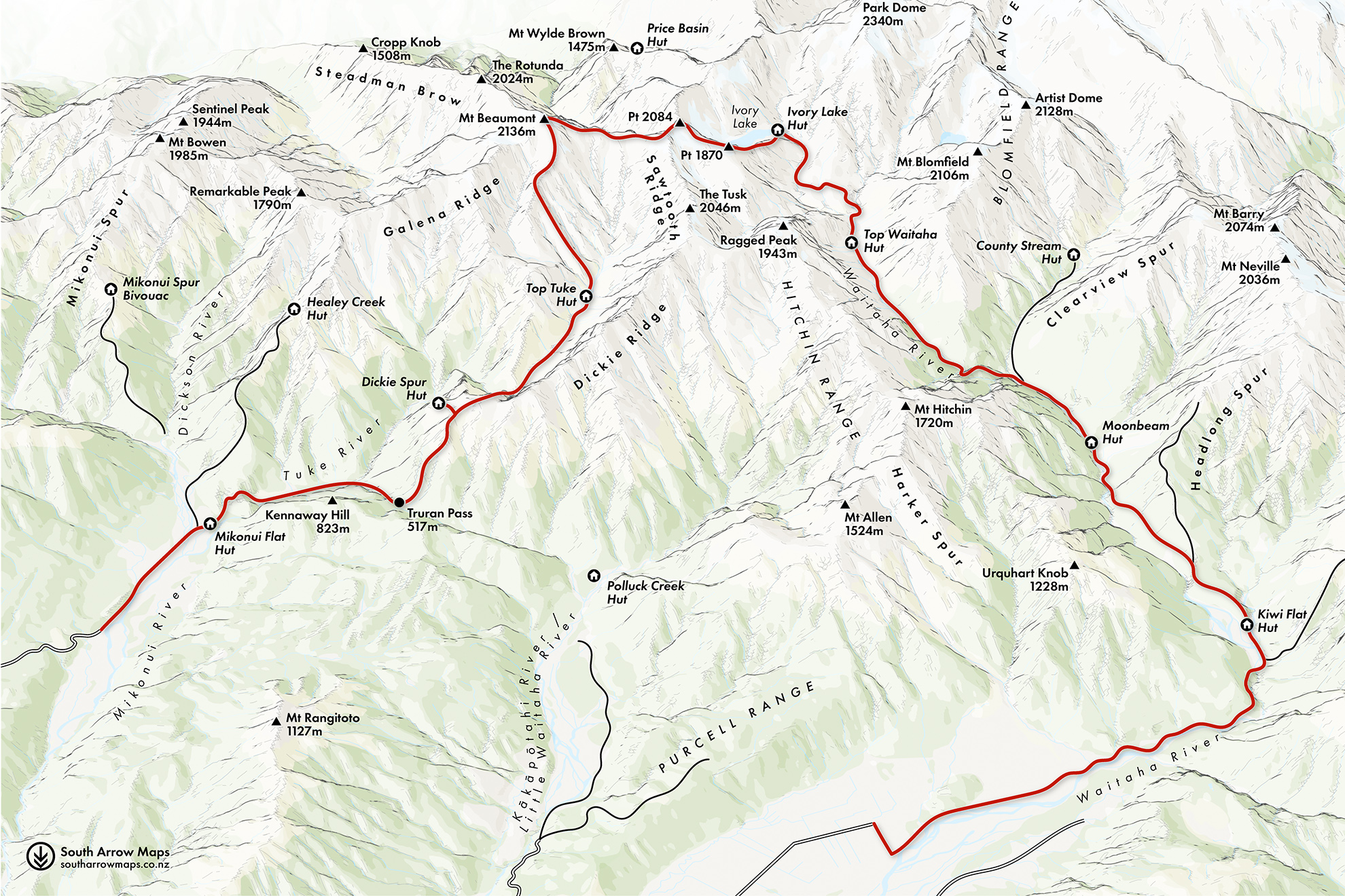
This force has been noticed: Morgan Gorge is Westpower’s proposed site for a run-of-river hydro scheme, one of the 149 projects listed in the government’s Fast-track Approvals Bill. Whitewater kayakers have protested vehemently; this grade five and six gorge is an ultimate challenge.
From the swingbridge it’s a short walk over river flats to Kiwi Flat Hut. A hunter joined us at dusk and, after a friendly chat, set off to pitch camp and find a deer. Later, when we tried to go outside to brush our teeth, we found he’d bolted us in from the outside. The windows were fitted with fly screens so there was no exit that way. After much whistle blowing and yelling, the hunter finally returned with some handsome antlers and, with apologies, let us out.
The next day a steep climb to the terrace above the hut led to a wide, flat track that we galloped along for about a kilometre. The easy travel stopped abruptly at the turnoff to Headlong Spur, after which it became a steep, gnarly sidle through bush that continued for a few hours until the track dropped back to the banks of the Waitaha.
We’d seen no one all day and arrived at Moonbeam Hut mid-afternoon. Our much-feared epic day would be next, so we didn’t feel guilty as we lazed in the afternoon sun. The familiar layout of a classic Forest Service six-bunker gave the three of us a bottom bunk each, and we lay with mugs of tea, sharing stories from the hut book. As the day grew hotter and moisture evaporated from the ground and forest, jungle mist crept between the trees.
The Waitaha is renowned among trampers for its brutality, but to kayakers it’s the Holy Grail. The river is relentless, plunging 36km to the Tasman Sea through steep schist boulder country with two cruxes: the Windhover and Morgan gorges. Only a handful of people have had the guts and skill to kayak ‘source-to-sea’. The hut book detailed journeys of kayakers and trampers and included an in-depth description of the first kayak descent – including injuries, separations and hardship.
Suddenly we heard voices and a noisy group of youths bounced in. They had no packs, but slung about their bodies were canvas bags, paddles and helmets. After cheery greetings they retreated outside to lie in the grass and the skunky smell of another form of jungle mist wafted in the open window.
These were the kayakers we’d been reading about, attempting another source-to-sea but foiled for the moment by too much water in Windhover Gorge. At dinnertime one of them patiently carved six wooden spoons so they could dig into their packets of dehy. The highest tech paddles and helmets, but not a titanium spork among them.
We were on our way by 6am. Initially the route is well maintained and easy to follow. After we crossed a swingbridge near County Stream the track climbed steeply, almost 400m, to get us up and over thundering Windhover Gorge. It then dropped quickly to Chainman Creek, the point where the track ends and where the kayakers had left their boats. The bright plastic hulls peeped out from a cave above us.
It had taken us three hours to reach the creek – about a third of the distance to Top Waitaha Hut. The view up-river was terrifying – house-sized boulders, raging cataracts and dense bush pressing in on both sides.
From here the real slog began. We were travelling about 200m an hour in the river bed where we could, but had to make lengthy forays into the bush to climb around impassable sections. There were teasing glimpses of the open tussock of the upper valley – it didn’t look far but progress was infinitesimal. It started to drizzle and misery set in. There was nothing for it but to keep pressing on. The sight of a whio playing joyfully on a rapid cheered us momentarily.
Eventually, however, we were through the scrub to the tussock where travel was easier – though not that easy, with big holes and savage spaniard plants.
It was now raining heavily and we were tired, but we glimpsed Top Waitaha Hut and soldiered on. Twelve hours after leaving Moonbeam Hut we arrived, sopping wet, cold and exhausted. Our kayaking friends had told us where their food stash was and to help ourselves, and we gorged on Cookie Time biscuits as we tried to warm our hands enough to get the stove going.
The rain continued overnight and all the next day, as forecast, and we luxuriated in a planned pit day of stories, a crossword or two, endless hot drinks and Sam’s inventiveness with our limited food rations. What’s not to love about a greasy cheese and tuna quesadilla for lunch?
The next morning was flawless. The green and tawny vegetation looked spectacular and everything was clean and crisp as we set off to Ivory Lake Hut. This top section of the Waitaha Valley is flat, wide and easy. As the valley narrowed we climbed onto a plateau on the true left and dropped into Stag Creek.
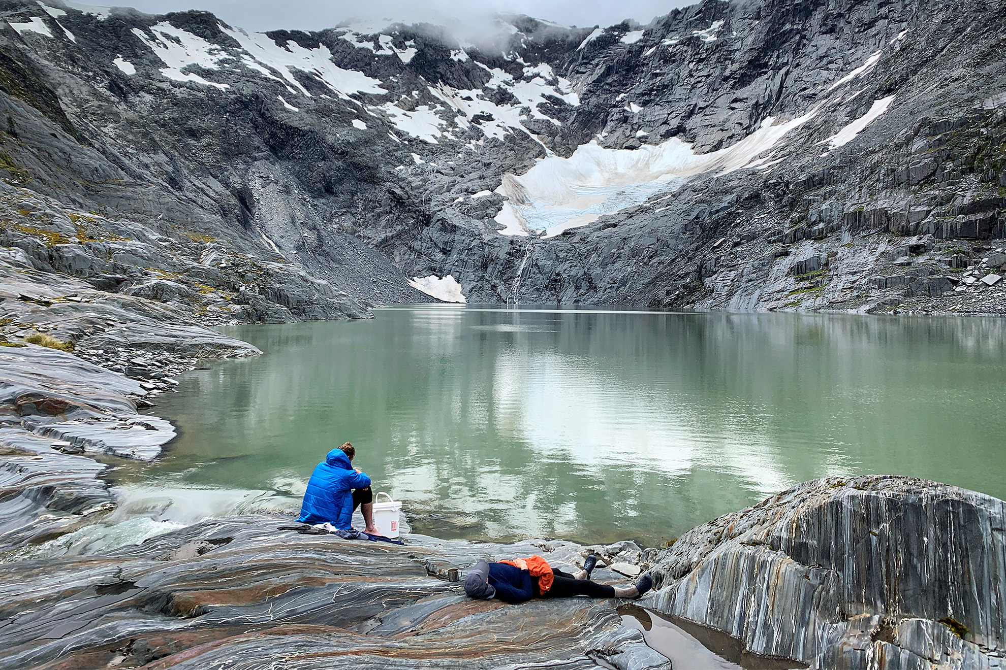
From Ivory Lake an impressively steep waterfall tumbles 180m into Stag Creek. We picked our way up beside the waterfall, through schist ramparts, across some scree sections and then tussock, and finally arrived at the lake.
Ivory Lake Hut was built for the Ministry of Works in 1970 to allow the monitoring of glacier and snow dynamics. The MOW research team, led by glaciologist Trevor Chinn, collected data that has aided the understanding of climate change. The glacier at the head of the lake now looks like a dirty grey patch of snow, about a third of the size it was when monitoring began.
The six-bunk hut still feels like a scientists’ lair with some old government department furniture, a few instruments, and charts and maps on the walls. There’s a good selection of photos of the madcap fun Chinn and his crew had while undertaking their serious scientific work.
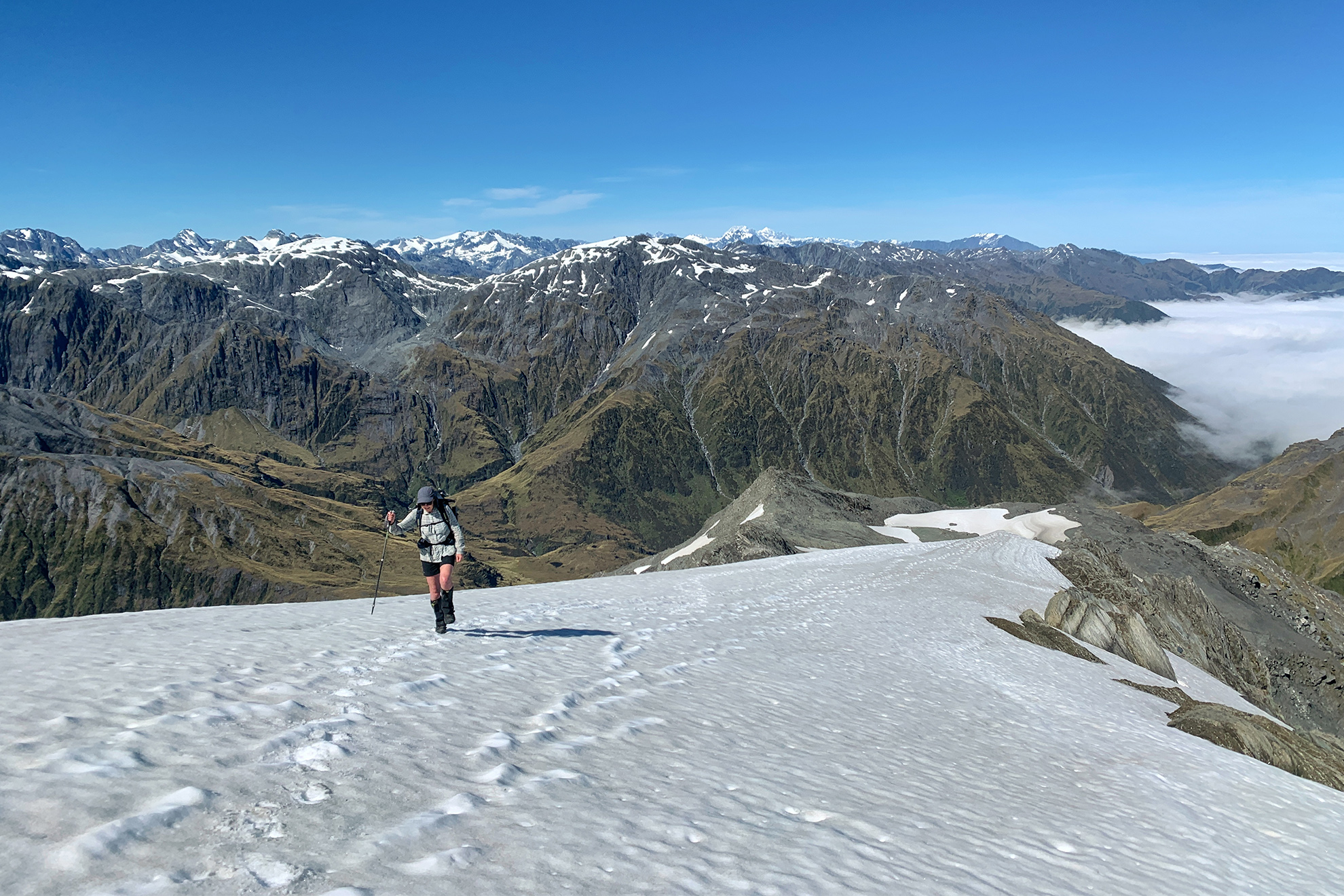
It was a relief to have negotiated the savagery of the Waitaha, but the next day we needed to summit Mt Beaumont (2118m). On the map the contours around Beaumont are coloured blue, indicating snow and ice. We’d taken a gamble and between us had just one ice axe, a short section of rope and no crampons. An experienced Canterbury party whom we’d met coming the other way had looked askance when we told them this.
We were up early for another long day. We crossed the lake outlet carefully – one misstep and you’d be in the waterfall plunging to Stag Creek. The cool early morning was perfect for the long steady plod to Beaumont Summit, and within an hour we’d come to a short section of firm snow. Sam used his ice axe to cut steps across this to where we regained easy rock and tussock terrain. Then there was a steep rock step. This is what Sam had brought his rope for, and it gave me confidence to be on the end of it to negotiate the short climb.
We were on a magnificent ridge. Looking back we could see the Southern Alps spread before us, Aoraki and Tasman in the distance and the daunting pyramid of Mt Evans. Back in 1955 our father had made the first ascent of the northeast ridge of Evans, so the view was special.
The next patch of snow had been sun-softened, so the risk we’d taken in not bringing crampons paid off. We were on the top of Beaumont by late morning and skidded quickly down a shingle slide on its northwest flank towards Tuke River.
With the snow and ice hurdles behind us, there was still a navigational crux to tackle. Friends had recently had difficulty finding the route into the Tuke. Over a cup of tea at lunchtime we pulled out all navigational aids – the GPS map on the cell phone, the paper map, various notes and a compass. We weren’t taking any chances.
Our care paid off. A little way down our chosen spur was a cairn, and not long after that a pole. Paul galloped off. Just before we reached the Tuke, Sam and I lost the route and found ourselves in a mire of matagouri and other prickly things. It was a relief to reach the river at last and to immerse my battered knees in the snowmelt. Another kilometre of river travel and a short climb brought us to Top Tuke Hut, which we had to ourselves.
Another glorious day dawned and we set off down Tuke River, hugging the true left bank, clambering over large boulders and wading over sidestreams. The roar of the river left no space for conversation and we each puzzled our own way through the obstacles the river threw at us. Occasionally I’d find a hand thrust towards me to pull me to the top of a bank or boulder.
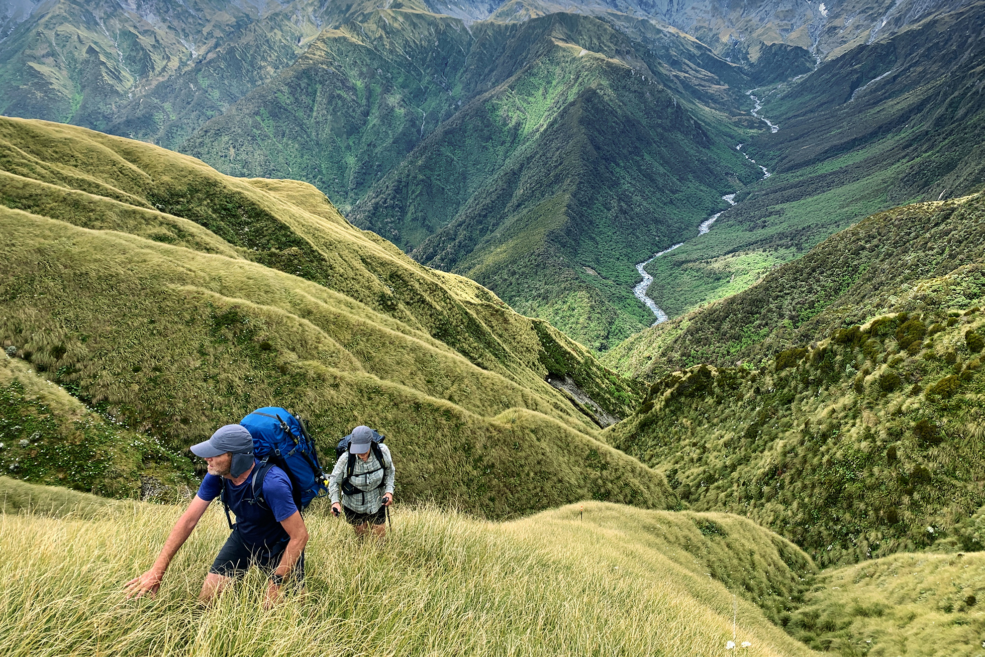
Where the Tuke takes a sharp eastward turn, the route diverges up a steep sidestream onto Dickie Ridge, a challenging 500 vertical metre slog. We pulled ourselves up on branches and clambered around waterfalls. I went on strike halfway up, so we stopped for an early lunch.
When we emerged onto Dickie Ridge it was as though we were almost there – seagulls soared overhead and we could see out to Hokitika and the beach. We texted friends and family to let them know we’d made it to Ivory Lake and were almost out.
At Dickie Spur Hut we had the company of a dairy-farming family of four who’d made their way in after early milking.
The final day took only four hours and was mostly downhill. We cruised through Truran Pass back to Tuke River, then climbed over another hill to drop into the Mikonui catchment. After a snack at Mikonui Flat Hut it was full steam ahead across a couple of kilometres of flat farmland to the car.
I didn’t feel entirely broken, but I did have a good collection of bruises to show for our eight days in some of New Zealand’s most exciting tramping country. Hokitika’s cafés were humming with tourists but we found a vacant table at one. The jungle mist rolled in once more as we tucked into plates of bacon and eggs.