
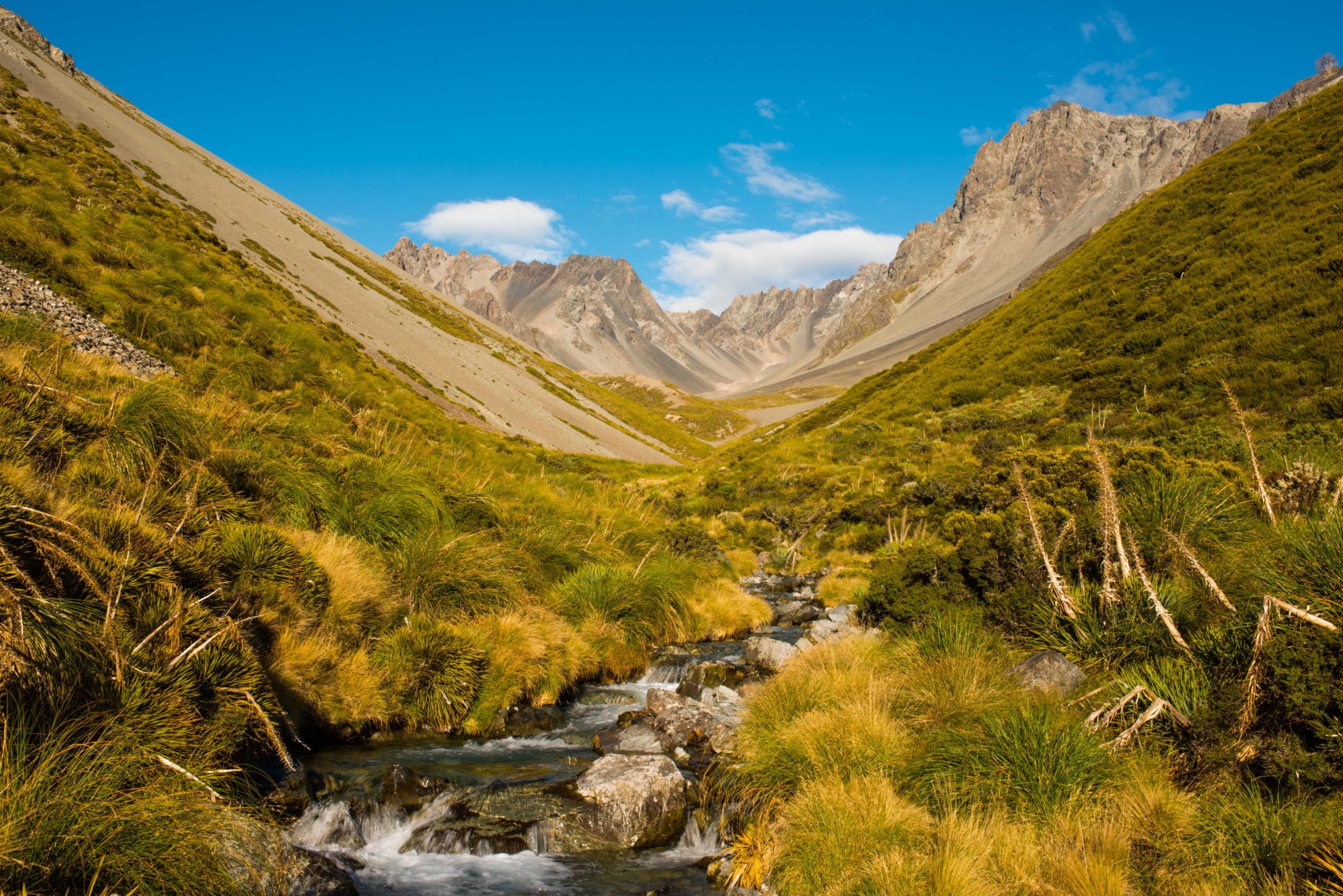
The view to the head of the valley is remarkable – ring-fenced by many of the high Two Thumb Range summits, all over 2400m, of which Achilles and Myrmidon were the most visible. They made for a stark and foreboding presence, hanging above the alpine cirque at the valley head.
We were up and walking before dawn, accompanied by a warm and gentle breeze sailing in over the summits. A southerly change was forecast for around midday and we planned, and hoped, to be over Brabazon Saddle before that. Though it was not an especially strong southerly change in the offing, it is always nice to have that pass or summit behind you before the weather strikes.
The saddle sits at 1731m between the south branch of Black Birch Creek and the Bush Stream catchment. It’s a straightforward ascent and route, in tramping terms, but experience has shown me that nothing is ever really that easy when it comes to off-track travel.That was 90 per cent of our route, and we needed to find the most expedient way up and over.
Though not bushed, bluffed or barred, the route out of Black Birch Creek was a steady pull with frequent pauses to ascertain the best way forward to avoid those three Bs just mentioned.
We gained the terraces above a small gorge which had threatened to bar access to the upper valley. Here there was a real feast for the eyes with the modest flow of the stream constricted by steepsided mountains covered with luxuriant tussock and vibrant stands of sub-alpine scrub – thankfully confined to the riverbed regions and easily avoidable.
The sky, blue and brushed with wisps of high cloud, precursor of the southerly, arched over peaks and ridges, but our pass was still out of view.
By the time we reached the foot of the pass at 1500m, the morning was well spent and we took an early lunch before the rather intimidating final 230m ascent. Fingers of cloud were already drifting over the range tops to the north as we began the climb on steep, loose scree, fighting to stay upright and maintain forward progress all the way to the broad saddle.
At the top, it was ominously still. Behind us, the scene had deepened to include neighbouring valleys and peaks, but to the south and our direction of travel, thick heads of grey cloud were advancing along Bush Stream. The southerly was coming.
Still, we saw no cause to hurry. It was only midday, so we took the opportunity to scamper up to the ridgeline, another 100m higher, to view the high peaks of The Thumbs, 2505m and 2546m. Unfortunately, their summits were both sunk in the cloud base which was rapidly lowering. However, we had a fair view of the dramatic upper cirque in which they lay before hurrying off down to the saddle and on into the stream below.
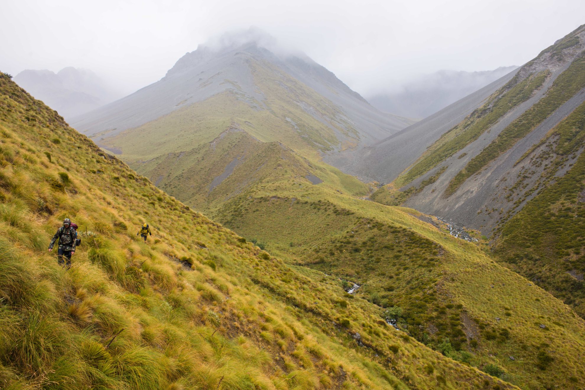
The first 300m of descent from the saddle was a painstaking process, akin to walking over a plain of golf balls canted over at 30-degrees, making it hard to stay upright and descend at the same time. Once we hit the streambed below tussock terraces, easier travel allowed much quicker progress just when the southerly finally arrived and drenched us with heavy, cold showers. Much of the valley was now blanketed by cloud and gales lashed in with more rain and blustery travel through the tussock zone.
Stream travel gave way to a major fork which we negotiated carefully through steep scrub and tussock. The rain and gale whipped around us as we descended to river level and then climbed again onto a high sidle route angling around the face to eventually gain the broad terrace where Crooked Spur Hut stands.
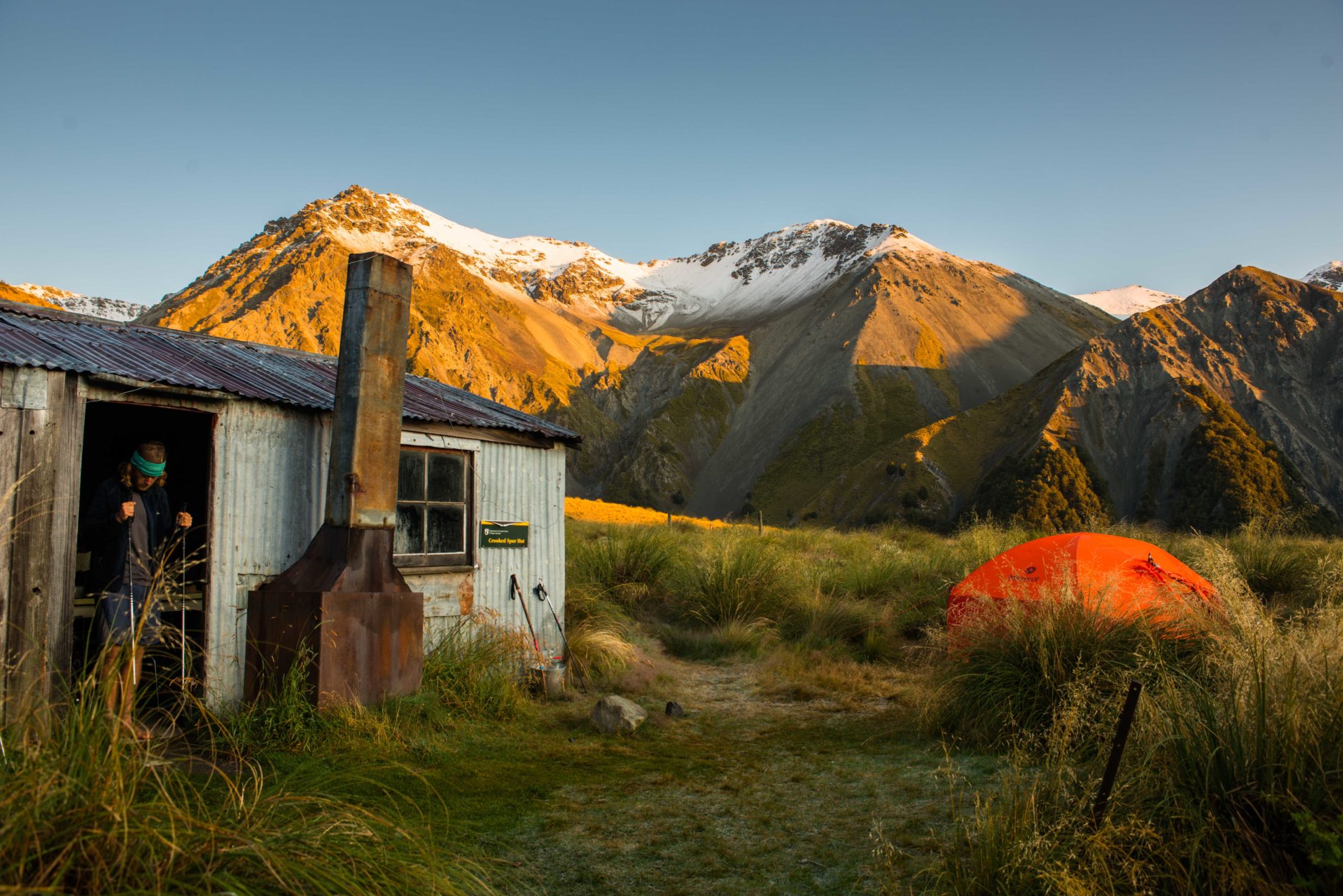
It was a relief to see the outline of the hut, perched on the terrace edge and backed by the sheer faces of Mt Sinclair to the south-east.
I envisioned a quiet afternoon on the bunks as the rain beat down on the roof with maybe a couple of Te Araroa walkers to chat with (Crooked Spur Hut is part of the trail between the Rangitata and Lake Tekapo).
A row of walking poles leaning against the hut greeted me as I approached and there was a soft murmur of voices from inside. Pushing through the door, I was amazed to see an absolutely full hut. Every bunk taken, every chair occupied, and hardly room to stand; packs, boots, gear and paraphernalia just lying about.
“Ok, take a deep breath,” I thought. “Welcome to the reality of the TA on a wet day.”
When Tim and Nick entered, we managed to find a couple of corners to stow gear and set up the Primus, thaw out a little and chat with our new friends – all 12 of them in an eight-bunk hut. Still, it wasn’t too onerous – there were plenty of stories to swap and a long afternoon to imbibe copious brews, biscuits, and chocolate as the rain fell monotonously outside.
On evening, the freezing level dropped and snow fell on the surrounding peaks, down to around 1600m, still well above the hut which sits at 1000m. But it did make for a cold night and so the extra warmth of all those bodies was welcome in a hut with no firewood, nor any trees nearby, and particularly when you are relegated to sleeping on the concrete floor.
Dawn couldn’t come soon enough, though I had had a surprisingly comfortable night, courtesy of the full length mat loaned to me by one of the trail walkers. Better than my half length mat for sure.
It was fine and beautifully clear outside, with frost around the hut, snow on the tops and a great ball of sun slowly lifting above distant hills on the far side of the Rangitata. With a steaming mug of tea in hand, we could not ask for more in such a grand setting as we watched the various groups depart knowing that we had only a half day walk down the river to reach my ute.
Malcolm Prouting, the current owner of Mesopotamia Station, flew in to land right outside the hut in a whirl of rotors and turbines in his Hughes 520N heli. He’d dropped in to pick up two hunters we’d shared the hut with. They were expecting to walk out, but Malcolm had decided they needed a ride, all four minutes of it, back to the car park. It would take us four hours.
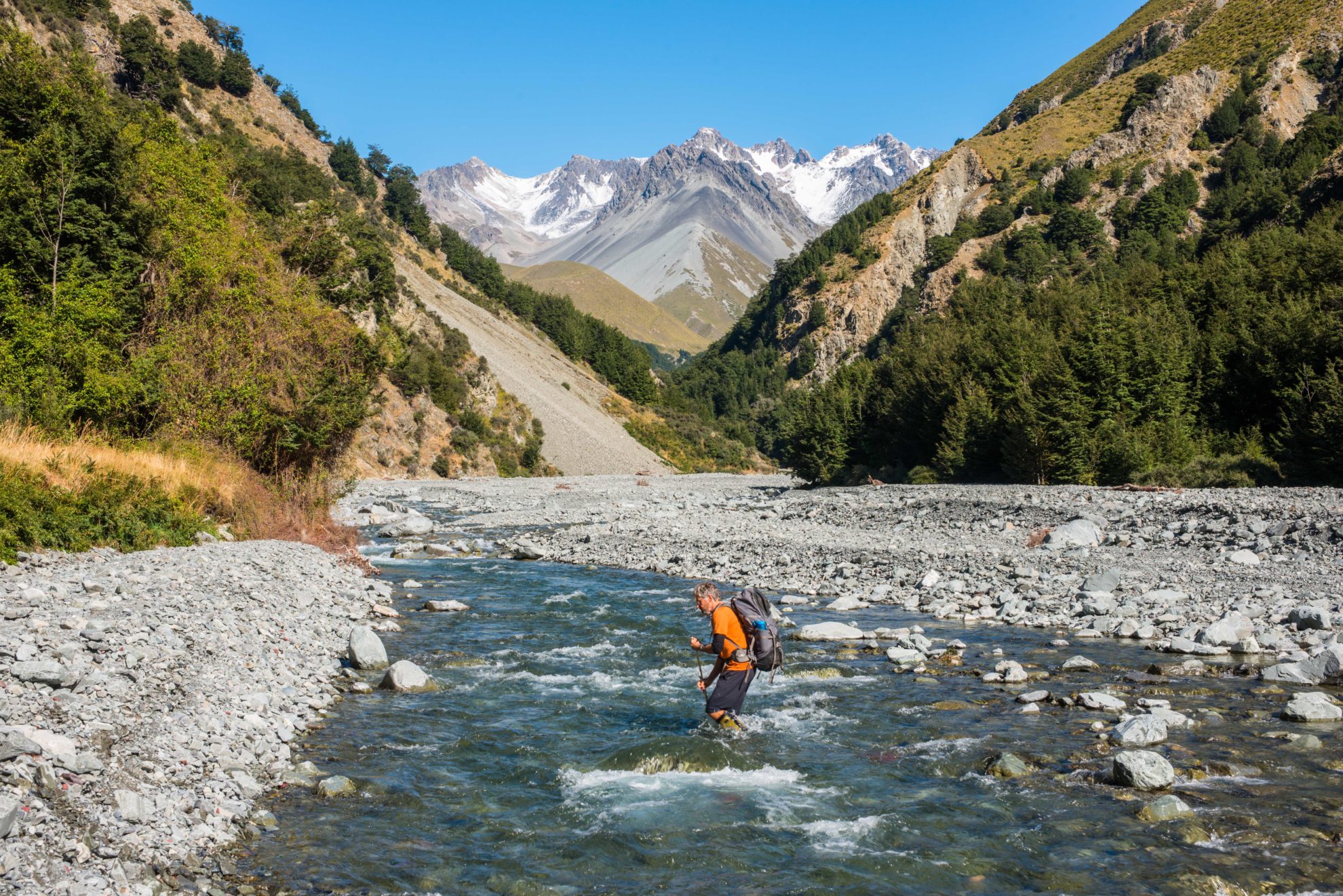
Yet I wouldn’t have savoured the ride, because I really wanted to see the Bush Stream that had thwarted us last time we were here.
It was an enjoyable tramp with a short steep descent from the hut to the riverbed and then, with the river low, we followed the first gorge out through multiple swift fords to an easy scree-bash which took us downstream all the way to the Rangitata and so avoided another high sidle on the track beyond the first ford.
Along the way, there were great views over our shoulders, back to the high peaks of the Two Thumb Range, dashed with snow and to which we could give a thumbs-up to taking the high road to Crooked Spur Hut.


