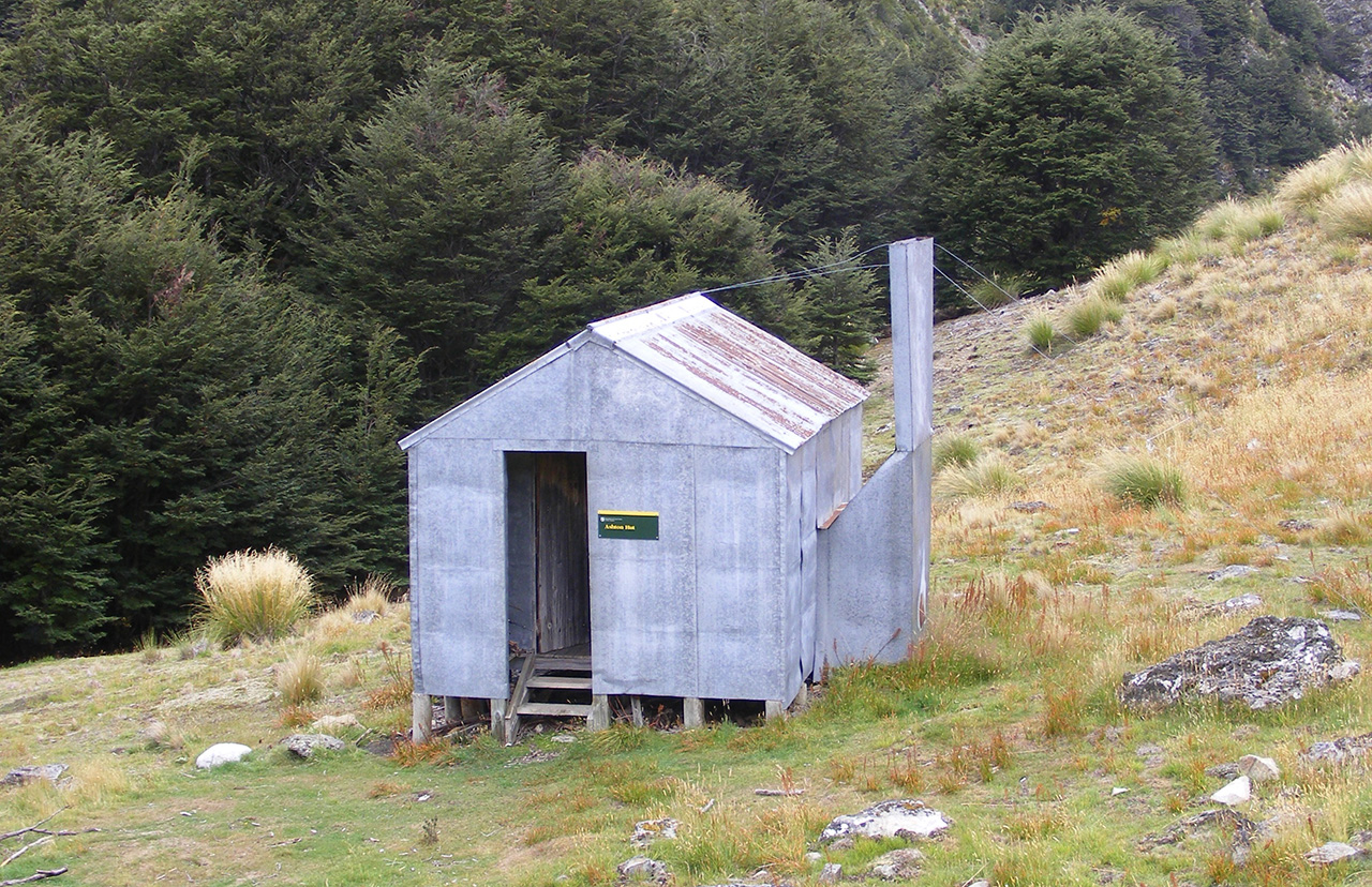
Ashton Hut, Eyre Mountains/Taka Rā Haka Conservation Park, Southland
A trip to Ashton Hut in the Eyre Mountains takes a bit of effort, which means it is rarely visited.
After a night camping at nearby South Mavora Lake, we set off from the road bridge over the Oreti River. There’s a 4WD track down the broad valley, leading us, after an hour, to the crossing of the Ashton Burn.
We then faced 700m of unrelenting, untracked grunt to climb the large ‘hill’ that is Pt1330. Strong winds kept the temperature down, but stripped the oil from our skin to ensure a good dose of sunburn. As we climbed, spaniard became a prevalent species, leading to the occasional painful stabbing.
When we stopped for a breather, we contemplated the controversial proposal for the Round the Mountains national cycleway to go down the stretch of the Oreti River below. The local council wants to route it down the river, taking it off-road after 40km on the dusty road from Lake Wakatipu. Fish and Game say doing that would ruin an internationally significant wilderness fishery. The Environment Court will decide if it goes ahead or not. It seemed to us the argument about moving away from roads would be stronger if long stretches didn’t run beside state highways further around the mountains.
The wind put us off climbing to the summit, and instead we took the advice in Moir’s South and sidled its northern aspect. The descent into the next catchment looked steep, and it was clear that finding a route into and out from Ashton Stream would require care. This is where having dodgy knees can be an advantage. As I brought up the rear, Eric had to try a couple of false leads and retreat, while I never once had to retrace my steps.
A slither through a patch of beech brought us to a comfortable crossing, and then a short climb out of the trees on the other side soon had us at the hut.
Ashton Hut is a Forest Service four-bunk model, in good condition. The hut book, which is half full, dates back to 2001. A design feature that I either hadn’t seen at similar huts or hadn’t noticed is that the ceiling space is open to the porch/woodshed. This provided excellent accommodation for the resident possum.
Although it was only early afternoon, the hut’s location deep in the valley meant any excursion would involve regaining all the height we’d just lost as well as battling the wind again, so we opted for a siesta until it was time to contemplate curry and a couple of drams.
A few entries in the hut book mentioned heading out over a 1506m peak – essentially traversing the headwaters of the stream we’d crossed. We briefly considered this, but decided that it would involve a couple of extra hours, so we mostly retraced the previous day’s route instead.
By the time we reached the valley, the wind had turned nor’west, so the last hour up the flats of the Oreti was a bit of a trudge. But we’d made the best of a bad forecast, picked the best of the weather and had a successful trip to somewhere new.