
The experts all agree: there’s gold to be found on Stewart Island. It’s not the kind that flashes in the sunlight, or lies on the bottom of a stream, though. This gold floats on the sea until it washes up on Mason Bay where it waits to be discovered by treasure hunters.
I first heard about floating gold, or ambergris as it is technically known, from Jessica whose last name I never learned. I don’t normally talk to strangers on a plane, but Jessica was sitting next to me and prior to taking her seat I spilled water all over it, forcing me to apologise profusely and offer to swap places.
Ice broken, Jessica provided fine company for the flight from Auckland. She happened to know a lot about sperm whale vomit, which is essentially what ambergris is before it is magicked into perfume by companies like Calvin Klein. She was a 14 year veteran with DOC, seven of those heading the department on Stewart Island, before taking redundancy in the latest restructure, which by her account is going ‘swimmingly’.
“Keep an eye out for ambergris,” she said knowingly when she found out I was heading for her old stomping ground. “Mason Bay is tops for that. Locals even go over there specially to scour the beach for it.”
Jessica might not have been so open about where to find the fabulously valuable floating gold if she had known what happened to the last person to share the closely held Stewart Island secret. English molecular biologist Christopher Kemp received hate mail and threats of legal action after writing his 2014 book Floating Gold: A natural (and unnatural) history of ambergris. He’d foolishly mentioned that Stewart Island was known for its high-quality ambergris.
Some secrets are best left unshared.
Jessica also warned the Southern Circuit is not for everyone. “It’s tough,” she said. “It’s for people who have done some tramping before.” I guess that wasn’t really a secret, but I still wished she’d left it unsaid.
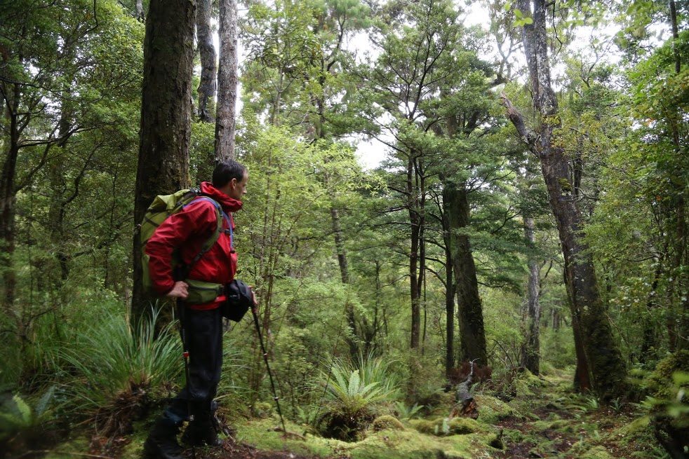
My excitement at visiting the island and spending the next three days exploring its southern reaches was suddenly replaced with apprehension. I’d seen the photos and heard the tales of the notorious mud and track flooding, but always assumed they were exaggerations or rarities.

Perhaps sensing my growing unease, Jessica asked if I had ever seen a kiwi in the wild before. “Well you will by the end of this trip.”
I was doing a reverse loop: Mason Bay to Freds Camp Hut via Doughboy Bay. Most trampers go the other direction, ending at Freds or Freshwater Landing, but doing it my way I began with a flight over the island and would end with a water taxi back to Oban.
But the flight from Oban revealed nothing of the island other than a long line cut through the bush: the well-graded Mason Bay to Freshwater Landing Track – a popular day walk for those short on time but with high hopes for spotting a kiwi. All other landmarks of interest were shrouded in cloud. Mt Rakeahua – my destination in two days’ time – was completely obliterated by a wall of uncompromising grey.
After landing at Mason Bay, I began my solitary walk along the beach, heading south directly towards the ever-darkening sky. The wind tugged at my clothing and whipped the sea into a frenzy of white froth and spray. Though I had a long walk ahead, I couldn’t help but zigzag my way up the vast beach, inspecting every rock, pebble or strange-looking object. If there was ambergris there, I was determined to find it. But truth be told, I had no idea what I was looking for so doubt I would have recognised it. By the time I had reached the end of the beach, some six-kilometres later and near Ernest Islands, I’d resigned myself to the fact I would have to seek my fortune elsewhere.
But rounding a bend moments later, I struck gold of a different kind: surely what will be a once in a lifetime sighting of a wild Stewart Island brown kiwi. It was fossicking in the scrub beside the track just a few metres ahead, completely oblivious to my arrival. I watched it for a few moments, photographing and filming it. When it finally noticed me, it ran off, prehistoric-like, down the track, stopping to see if I had given chase. Eventually it scarpered into the bush.
Elated, not even the onset of rain nor my first brief encounter with mud could dampen my spirits.
The track headed inland for some distance, eventually entering a grand podocarp forest where I found a beautiful site overlooking a lush gully filled with ferns of every shape and size and the carcasses of toppled trees to drop my pack and stop for lunch.
The rain fell more steadily, but the track was lovely. So soft underfoot, it was perfect single track and I lost myself for about an hour in the glory of walking it. It’s the kind of track that makes you feel like you’re bouncing along, despite your heavy pack, and that you could walk for hour after hour.
I guess I became complacent. I’d been gradually climbing Adams Hill since leaving Mason Bay and was on a relatively flat section of track just before the final climb to the 401m summit when suddenly my leg disappeared, completely lost in mud. I prised myself free, then it happened again. And again.
Because the soil on Stewart Island is so shallow, roots intertwine just beneath the surface and each passing foot weakens the web-like structure so that what held one person might give way completely for the next. Flat ground is where the mud is at its worst and there are few flatter places than the summit – plateau really – of Adams Hill and neighbouring Doughboy Hill.
As I walked along the kilometres-wide undulating camel’s back of Adams Hill, the weather threw a hissy fit. The wind howled, driving the rain horizontally. Cloud swirled and I could barely see 50m ahead. Each time the trail headed in a downwards trajectory I thought I’d passed the summit, but there always seemed to be more hill. In the depressions, deep holes awaited. I skirted what I could, following the footprints of previous trampers ever wider around mud pits that looked like they could swallow a tramper whole. Those who say ‘stick to the track’ to avoid causing erosion have obviously never tramped on Stewart Island. Such high ideals are quickly forgotten there and tracks have widened over the years as trampers sought dry, mud-free passage. And there is always a way, if you put the time in to find it.
I passed some tor-like boulders and assumed them to mark the summit but barely gave them a sideways glance, let alone stopped to admire them in the gloom.
Abruptly I was on the descent. I stepped on tangles of roots which on any other track would give me pause to watch my footing, but here they offered solidity and protection from the energy-sapping mud.
It was like walking down a stream, though. The roots were sharp and jagged and the track full of moving water and deep pools. At one stage I slipped, my left foot skidding towards my right and for an instant I saw myself falling into a heap onto the spikes below, but I slapped my pole out, managing to halt my slide before gravity kicked in.
Before long I found myself back on glorious single track: a brown trail bisecting a sea of green. The rain eased and the track became springy again. The mud and misery of Mt Adams was quickly forgotten. It’s the perfect tramping track and I thought how fortunate I was that people have cut a route through the bush just so people can explore it.
Doughboy Bay Hut had three others inside when I arrived. Brian from Hamilton and Nick from Westport were on their annual get-together tramp while Luke from Hawke’s Bay had packed in his job to travel New Zealand for a few months, tramping as many trails as he could before summer ended. He was a machine, having walked from Rakeahua Hut to Doughboy in four hours – half the recommended time.

Brian and Nick had started out from Freds Camp a couple of days earlier and were having a rest day, Keen speliologists, they’d spent the day exploring, finding the cave where one of Doughboy’s most famous residents, Keiko Agatsuma, lived for a week in 1978. She had travelled to New Zealand from Japan on a tourist visa, intent on getting away from it all. She spent five months on Stewart Island, living in huts and caves before finding her way to Doughboy Bay, which is about as far from it all as you could get. Unfortunately for Agatsuma, she was deported for overstaying her visa after a hunter found her and convinced her to go to Bluff for medical treatment.
On their wanderings Nick and Brian also stumbled upon a kiwi right beside the track.
We’d just finished eating our dinners when a family of five arrived, utterly sodden. Wet through, the kids couldn’t even offer a grin, but their parents wore proud smiles. It turned out they’d come the same way as me, but whereas I took seven hours, they’d taken more than nine. They were Swiss and the parents had brought their children to New Zealand to show them the places they had tramped to, including Doughboy Bay Hut, on their last visit in the 1990s. We were all impressed that the children had managed the tramp in such appalling conditions. It just goes to show, you don’t have to be an experienced tramper to walk the Southern Circuit. A willingness to give it a go will do.
We stoked the fire and chopped more wood. The soles of the father’s old army boots had fallen off the uppers, so Nick rummaged around the hut and found him a pair of cut down gumboots which he was very happy with.
The Swiss couple said not much had changed since their last visit. “The first time there was mud, but with sun,” said the man. “This time, there was mud but it’s wet.”
The next morning the sky was a leaden grey but the clouds seemed higher and it looked like the forecast clearance would eventuate. I scouted the beach a little way and came away with a sense of total isolation, something I’ve not felt at any other beach in New Zealand. I loved it. Such feelings of wildness and remoteness are hard to come by these days, but they’re still to be had if you put the effort in.
I hoisted my pack and began climbing Doughboy Hill. At 411m, it’s almost a perfect replica of the previous day: steep, rooty and muddy.
It soon began raining and the summit plateau was clagged in, just like Adams Hill had been. The wind was not so fierce but it was still cold so I raced on as fast as I could, slowed only by the summit plateau which hosted more mud pits than even Adams Hill had. My boots regularly disappeared into the mud and without any decent shelter or dry ground, I walked solidly to the Rakeahua River.
I crossed boggy swamps, tripped over manuka roots and fought my way through head-high scrub at the slightest hint I would otherwise sink to my waist.
Off the hill and in the Rakeahua Valley, the track became immeasurably more fun as the single track returned and I gained some semblance of shelter from the elements among the giant podocarps. I crossed several side streams, wading one or two, but most by balancing precariously on fallen trees, some narrower than my boots, as if I were a performer from Cirque du Soleil.
Two hours out from Rakeahua Hut a red deer hind bounded onto the track just ahead. I stopped, wondering if I could reach for my camera. I decided against it and instead stared at this magnificent creature. It looked directly at me, cocking its head to one side. Then it was gone. With luck it will have avoided the hunters scouring the island.
Rakeahua Hut is a tidy six bunker. I noticed a pair of solid looking boots hanging up outside and immediately thought of the Swiss family, who had decided to hole up at Doughboy Bay for another day. These would be far better than the gumboots.

With the fire going, I spread out luxuriously, hanging my wet clothes around the hut.
Overnight the cloud dropped lower and scuppered my planned hike up Mt Rakeahua. I was secretly glad; I’d slept poorly and felt ill and didn’t think I had the stomach for the five hour return trip plus another five hour walk to Freds Camp. Before the trip, everyone who knew the area had warned me it would be a tough ask in one day, but at 681m Mt Rakeahua would have made a nice high point of the trip, enabling me to see where I’d come from and where I was going.
The track from Rakeahua Hut began as boardwalk, but it’s not boardwalk as you might imagine. The semi-submerged planks are a far cry from the Tongariro Alpine Crossing and within five minutes had petered out and it was back to knee deep mud. Two hours later I left the bogs behind for good and was back amongst the podocarp. The tramping was gorgeous again.
There are lots of streams and creeks but nearly always there’s a fallen tree, or giant roots, spanning the gap to enable a dry, adventurous crossing.
I arrived at Freds Camp at 1pm and discovered my phone was too water-damaged to work and I could not arrange for the water taxi to collect me before our pre-arranged 6pm pick-up.
Freds Camp Hut overlooks North Arm, sitting right on the water’s edge. It has 10 bunks and hunters get ferried here all the time, which explained the big bag of coal.
Just as I finished hanging my gear over the woodburner, I looked out the window and saw a boat approaching. Thinking it was the water taxi coming to see if I had finished early, I quickly packed everything and headed to the jetty. Instead of Ian from Eco Taxi, I met Brent and Marty who had decided to pop over from Oban to lunch at the hut.
Brent let me use his phone, but Ian didn’t answer so all I could do was leave a message. Marty hauled a big bucket of crayfish and a bottle of Wild Turkey to the hut. The crayfish sandwich they made me was indescribably good, but it was the fresh oysters I remembered long after.
Just as we finished picking through the crayfish legs, Andrew and James, farmers from Gore, turned up in a dinghy. With some friends they had booked out the hunter’s block on the opposite side of North Arm. They took half an hour to unload their gear, which consisted of cooker, chilly bins and at least 12 dozen Speights.
When Brent and Marty headed back to Oban, Andrew handed out some beer and told me some hunting yarns. He shot a nice stag not far from the hut last year. He planned to go back to that spot and do the same this year.
They are young, smart guys with a good head for farming and they absolutely love hunting – especially pigs. I asked Andrew how the gear for pig hunting is different to deer hunting. “With pig hunting you need dogs,” he said. “And a knife for when the dogs don’t do the job. Deer hunting you just need a gun.”
So you just knife the pig to death? “Yeah.”
Is it fun? “Oh yeah.”
He’s got two freezers full of pork and deer at home and says barbecues are pretty good around his place because there’s never a shortage of meat.
Their friends turn up in a bigger boat and tell them to pack up, they’re at the wrong hut. I helped reload their boat and then stoked the fire. An hour later Ian arrived.
That night I walked into Oban for blue cod and chips, which I ate on the grass at Halfmoon Bay, swiping at the hungry sandflies. Afterwards, I went to the pub where Brent and Murray were well on their way. I ordered a round but by the time I finished my pint I realised I’d done my dash.
I walked back to my accommodation and was asleep by 8.45, dreaming of whale vomit, kiwis, mud and tramping gold.


