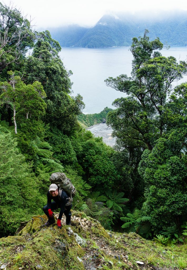
Impenetrable is not a term I use lightly when describing vegetation; one can usually insinuate a way forward with a little care and application. Patagonian bamboo thickets come close, and a Tasmanian horizontal scrub gully can also be challenging, but the dense interwoven stems of wind-pruned scrub on the steep slopes of the Haystack on the coast north of Milford Sound had us beat.
Glen and I came to this remote coast after being flushed out of the Darran Mountains by Fiordland’s infamous weather. We figured conditions on the coast would be more benign and, if we couldn’t traverse over the mountains, we might be able to complete a low-level circuit around them. The challenge of this planned route, and the biggest attraction, was the wild and untracked coast between Milford Sound and Martins Bay.
The first problem was getting there, the precipitous walls of Milford Sound precluded foot access. So in the dull light of a watery dawn, we perched on the bow of Rosco’s boat, bobbing on a small swell just north of Dale Point, at the mouth of the sound. A shore landing on the rocky coast was too risky, so we looked for a submerged rock to jump onto and hopefully avoid a swim.
Once ashore, and pleased only to have barely wet our shorts, we set off northwards, hopping and clambering over boulders backed by a steep and densely-vegetated slope. Within a couple of kilometres, excessive enthusiasm about traversing the coast saw us continuing too far around the first major bluff. Unwilling to strategically retreat, this led to a desperate and strenuous cliff climb with the stems of widely-spaced shrubs providing the only hand holds. A deer trail led us back to the coastal boulders beyond the bluff. More inland excursions proved necessary as the morning progressed, but we now took a more conservative approach to routes when bluffs loomed.
After thrashing through tangled wet scrub, we eventually met a broad ridge and an opening ahead turned out to be the top of a high loose cliff with the Thurso River cascading over rocks at its foot. We swung and slid down to the coast but there was no beach here, just outwash boulders and smashed tree trunks telling of the power of this river in flood. The Thurso is one of many rivers that we crossed on this steep coast, any one of which had potential to hold us up for days.
We had a hurried lunch on the rocks, keen to move on from the clouds of sandflies which seemed particularly invigorated by the still and humid conditions. After an easy stroll along a cobble beach, we came up against another bluff. It looked doable, but required a short climb up a slippery-looking algae-covered cliff, preceded by a dash across a gulch periodically menaced by dumping waves from the growing swell and rising tide.
We retreated and commenced another inland excursion. This was the longest so far, taking almost four hours to progress a miserly 600m along the coast. Our route was far from direct. We fought our way up a spur, packs catching on vines, sidled northwards as far as seemed reasonable, then descended hopefully, popping out into an open gully with flax clumps.
With 2015m Mt Pembroke just 5km inland, it was no surprise the coast was so steep. Pembroke is also the likely source of the contorted gneiss boulders we traversed towards Stripe Point. Aptly named, the outcrops and cobbles around this point are spectacularly banded and we saw quite a bit of them as we sniffed out a route past bluffs and gulches.
With the afternoon well advanced and no camping options apparent, despite the slope backing the coast easing, we slogged on over seemingly endless cobbles and boulders, wading the mouth of John O’Groats River, tired after a long day. Even here, we had to undertake substantial stonework using the beach rocks in order to create a site level enough to pitch the tent. Dinner on the beach cobbles and a cloudy but colourful sunset preceded an exhausted sleep.
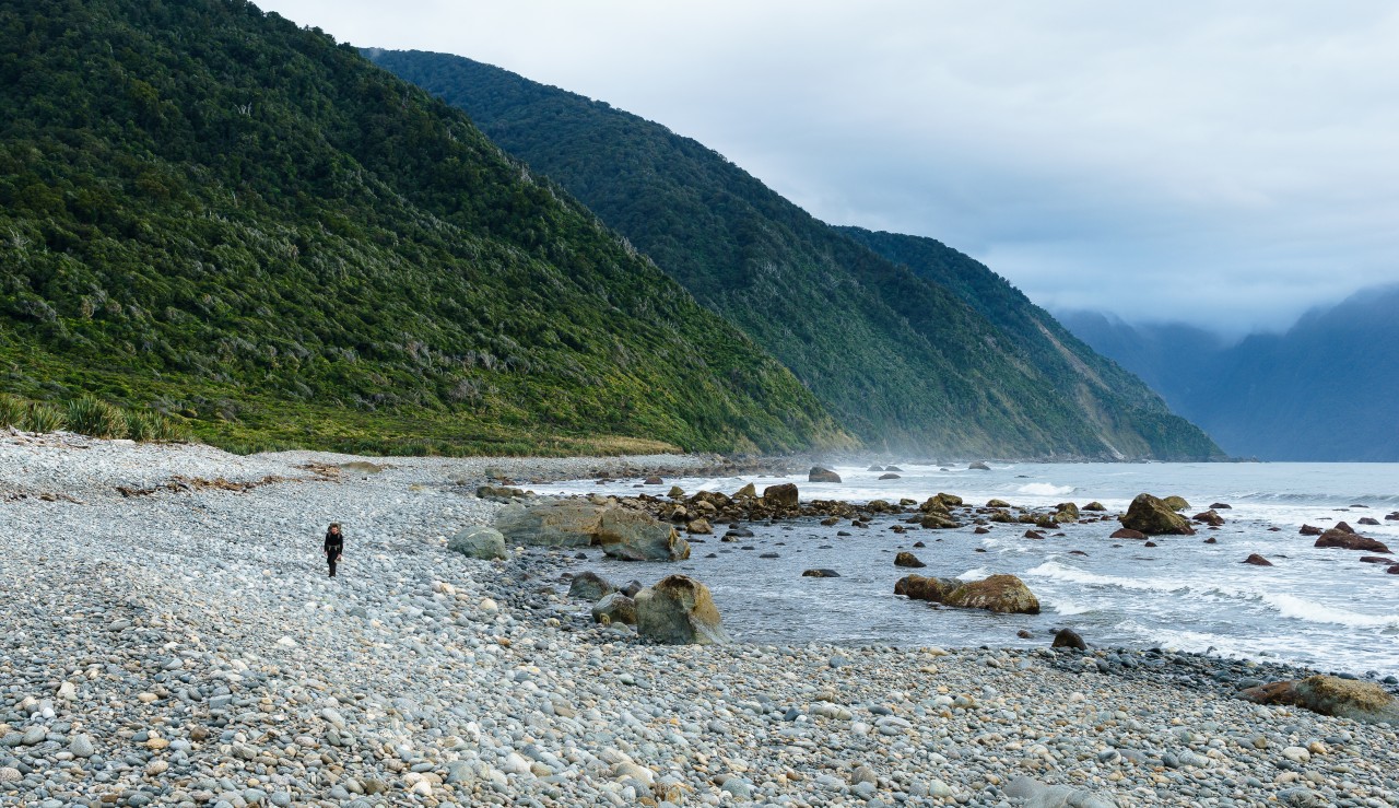
From John O’Groats to Madagascar Beach, the coast is mostly low with a series of cobble and sand beaches, and the straightforward walking allowed us to relax and take in the scenery. We rounded Yates Point, with much of the route traversing behind an extensive seal colony where both the smell and antics of the residents provided plenty of interest. We startled seal pups beneath boulders and they barked accusingly while scurrying away.
Shapely limestone stacks rose from the sparkling sea off Madagascar Beach. At the end of the beach, Wolf River debouches onto the sand amongst more limestone outcrops. An unexpectedly easy 200m ascent on deer trails led to an opening near the crest, with the blue sea providing a tropical feel to the view back along the coast. Open southern rata and silver beech forest followed, until an opening revealed the inviting kilometre-long sand strip of Sydney Beach below. The descent was less inviting, involving outflanking bluffs and hanging from trees on the steep slope.
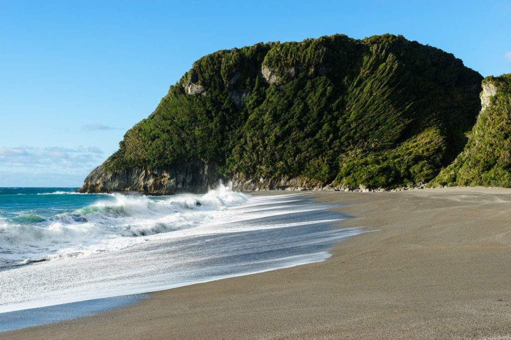
I spent the sunny, sandfly-free afternoon wandering barefoot on the golden sand and having a brief dip in the large pool at the base of Sydney Creek’s final cascade. The beach ended abruptly at the foot of the hulking 124m bluff of Haystack, its sheer face sheathed in wind-pruned vegetation. We clearly could not traverse it at sea level, but that was tomorrow’s problem.
A spectacular cloud band offshore warned of an imminent weather change. Indeed, it rained heavily overnight.
Walking along the beach next morning, Haystack loomed through the rain and Sydney Creek was now a roaring brown cascade spewing onto the beach. In an attempt to avoid the need to cross this spate somewhere, we tackled the dense scrub on the slope to the north. It was steep and slippery underfoot, small cliff lines forced us leftwards – the wrong way – and the interlocked stems ahead looked more intimidating than the bars of a prison cell. We made no progress and retreated to the beach. We then tried to clamber up beside the waterfalls before concluding it was too risky; a slip here would deposit us directly in the torrent and that would be that. Thinking laterally, Glen suggested heading back down the beach and climbing high up the coastal escarpment before dropping into Sydney Creek well above the waterfalls.
A meandering steep climb above the beach avoided the worst scrub thickets, and a steep sidle across several old landslips put us on a spur above Sydney Creek. After slithering down to some well-located boulders, we were across the creek following a steepening ascent, partly on deer trails again, to the ridge crest above. By now, the rain had eased and we rested in a beautiful ferny grove beneath southern rata trees.
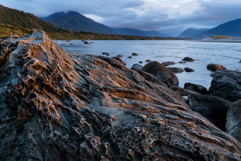
North from here, the forest remained mostly open, though there are few distant views with which to orient ourselves. Many small gullies added to the topographic confusion. We debated various options and eventually figured it out, descending steeply into Ruby Creek. Clambering over logs, rocks and small bluffs, we followed the creek to Ruby Beach, a small expanse of sand hemmed in by rearing limestone bluffs. The surging sand-laden sea has undercut the cliff at the northern end of the beach and polished the limestone pavement such that the network of veins in the rock formed spectacularly-displayed abstract patterns.
While enjoying a late lunch with just enough breeze to keep the ferocious sandflies at bay, I noticed the numerals 1885 carved into a soft sandstone boulder. Was this the work of some shipwrecked sailor? We mused about what it would have been like trying to reach the few settlers who remained at Martins Bay at that time. We were soon to find out, but not before enduring another adventure.
The only camping option at Ruby Beach was a small opening just behind the beach, behind which steep and densely vegetated slopes rose abruptly. It was not particularly well-sheltered and, again, required some stonework to create a level surface. Overnight there was a wild storm. Wind squalls flattened the tent and the roar of rain on the fly made sleep almost impossible and the outside excursions to secure pegs unpleasant.
The storm slowly abated in the morning and I finally nodded off about 4am, waking a few hours later to calm weather. Once again, it was clear an inland bash was necessary to continue northward. The ridge north of Ruby Creek proved straightforward, and we then traversed a rocky coastline in warm sunshine towards the high bluff overlooking the Kaipo River mouth.
The climb over this ridge was steep, but surprisingly open once beyond the coastal scrub band, and the descent was even steeper. We emerged onto a pile of driftwood beside the Kaipo River, the last river before the Hollyford and the largest so far. Having arrived at its mouth at high tide, we had to wander some distance inland across gravel and grass flats to find braided channels shallow enough to cross safely.
Much of the coast from then on was sand or loose gravel and energy-sapping walking. After a couple of hours, the sweep of Martins Bay opened before us. It was still another hour of gravel and boulders before we reached Jericho Creek. Spurning this campsite option we continued on an unexpectedly long walk through dunes to the Hollyford River, its size dwarfing any other river on the trip.
We had previously mused about swimming the Hollyford, but, now, as we contemplated the wide-moving expanse of open water, such thoughts evaporated. With perfect timing, the Hollyford Walks jet boat cruised by and we arranged to be taken across the river next morning. With our concerns about crossing the river allayed, we wandered the dunes and orange pingao tussock grass at sunset.
Once across the Hollyford, we spent a day doing little else than watching the seal pups at Long Point, then headed inland on the Hollyford Track. The up-and-down to Demon Trail Hut seemed not so hellish after the coastal bluffs of the past week – this part of the Hollyford Track was a highway compared to the trackless Milford coast. Lake McKerrow glinted through the trees and was admired from many small beaches along the way.
Beyond Pyke River, the Hollyford Track is mostly a path, and the easy walking allowed plenty of opportunity to admire the Darran Mountains rising steeply to the west beyond the beech trees until, finally, we reached the Lower Hollyford Road and completed our partial-circuit of these mountains.


34 years of inspiring New Zealanders to explore the outdoors. Don’t miss out — subscribe today.

Questions? Contact us