Mt Brown Hut, Stewardship Land, Hokitika
With the promise of a snow-laden southerly hitting coastal Canterbury, it was just the spur we needed to pack up and head over the Alps, where an unbroken line of suns adorned an otherwise gloomy weather map.
Being mid-July, the idea of high level camping was soon shelved in favour of a cosy little hut, preferably complete with a wood stove.
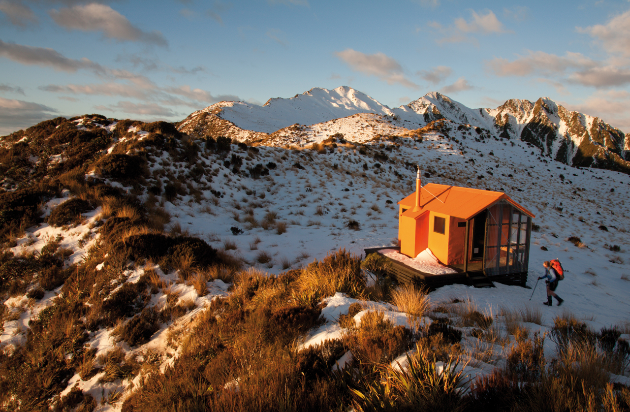
The almost brand new Mt Brown Hut situated just above the bush line in the hills behind Hokitika seemed to fit the bill quite nicely. This four-bunk hut was only completed in November last year, after more than 2000 hours of volunteer work and a large number of financial sponsors joined forces to realise this community-driven project.
A previously overgrown track from near the shores of Lake Kaniere to the new hut site in a tussocky saddle at 1120m had been re-cut and re-marked, making it a great destination for those who enjoy their West Coast experiences to be not entirely masochistic. In fact, this must be one of the most accessible above-the-bush line huts anywhere on the Coast, and has already seen plenty of visitors over the first six months of its life.
Even on a Monday there was a car at the start of the track, which is just a couple of kilometres south from Dorothy Falls along the Dorothy Falls Road. Since the snow was already falling thick and fast in Christchurch, we weren’t surprised that other like-minded souls had decided to escape westwards to the sunshine, but were also aware that four bunks aren’t a lot to go around.
The track indicator stated four hours for the 1000m climb to the hut, and as the winter’s day was no longer young, we hoped this didn’t refer to four ‘West Coast’ hours. Visions of floundering around after dark above the bush line in deep snow, searching for a hut whose exact position was unknown to us (and unmarked on our topo map), encouraged a degree of speed as we climbed steeply away from the lakeshore.
The forest was a typical, yet always refreshing, West Coast mix of rata, kamahi and majestic rimu, with a rich array of ferns and shrubs carpeting the ground to complete the scene. The freedom to wander through such pristine nature on a bone-dry, springy trail with dappled sunlight filtering through the canopy was the perfect panacea we needed after too long stuck in shaky towns out east.
Meeting the owner of the car below as he descended from his day trip among the forest, it looked like we now had the mountain to ourselves.
Along the way we were regaled by a number of very musical tui and bellbird, along with the not-so-musical treetop crash landings of overweight kereru. Old, frozen snow started to cover the track as the forest gave way to leatherwood and flax, and before too long we emerged from the confines of bush onto a scene of golden tussocks sticking out from the snow.
Waratahs showed the way above, and with the sun sinking far too rapidly into the Tasman Sea, we hurried along old footprints in the snow, arriving at the bright Forest Service-orange hut before the beautiful winter light had abandoned us.
The hut has a small, but efficient stove along with a supply of black gold for a freezing night such as this, and while the star-filled heavens and lights of Hokitika and the Kokatahi farmsteads twinkled in the blackness outside, we ensconced ourselves in this perfectly-sized refuge for a much appreciated shake-free night.
The angry clouds that brought all that snow to the other side of the mountains had all but dissolved by morning, leaving clear blue skies for an excursion above and beyond the hut. Mt Brown is unnamed on our old topo map, but was about a kilometre along the snow-covered ridge that would lead eventually to the Newton Range.
Accompanied by views over Lake Kaniere to the farmlands and coastline around Hokitika, this snowy bush-bash was quickly dispensed with. We were happy to call it a day at the first highpoint, the route east onto Newton Bivvy looked long and rough, maybe providing an excuse, if one is required, to return here in summer.
A more direct route home through the basin below looked straightforward although, without crampons, involved more step cutting than I have done in quite a long time.
With high clouds approaching from the Tasman, we took the road most travelled and retraced our steps from the previous day down from the hut, finishing exactly as the first raindrops landed on the dust of the car park.