Image of the January 2016 Wilderness Magazine Cover Read more from the
January 2016 Issue
Home / Articles / Wild Trips

Between Windmills and Water

A viewpoint offering unimpeded views to the Manawatu River and Te Apiti Wind Farm. Photo: Peter Laurenson
Area
Manawatu
Distance
7.63km
Time
3-5hr
Grade
Easy
Access
12km east of Palmerston North. Access the western end at the car park to the left of SH3, just before the gorge entrance. From the east (Woodville end), access is from Gorge Road
Map
BM25

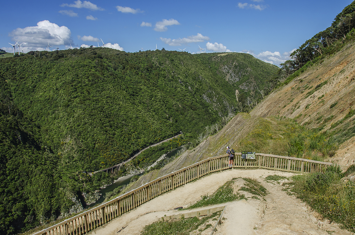
Manawatu Gorge Track, Manawatu Gorge Scenic Reserve

The Manawatu River existed long before the Tararua Ranges, now south of the river, or the Ruahine Ranges, now to the north. So, as the ranges rose, the unrelenting river carved the gorge.

The gorge walks offer an accessible nature experience the whole family can enjoy. The track is mostly through bush, offering shade on a hot day.

The Gorge Track is not a circuit, so there are a few logistics to sort out at the beginning and end. Walking in either direction is fine and it’s only 10km. Either end involves a fairly steep initial section, which then levels out a couple of hundred metres above the gorge. There are plenty of places to stop along the well graded, mostly smooth trail; and five lookouts offer nice views into the gorge and out to wind and dairy farms.

In fact, a point of difference on this walk is the electricity-generating windmills. Love them or hate them, they’re rather majestic structures, whether viewed en-mass across the gorge (Te Apiti Wind Farm) or individually up close (Tararua Wind Farm). You hear them before your see them – an ominous swooshing.

It’s a good walk in most weather because the forest canopy provides shelter from the wind, the sun and the rain. The native bush is mainly tawa and podocarp forest, with nikau palms and giant maidenhair fern, which is unique to the Manawatu, also in abundance.

There’s a significant conservation programme underway and birdlife is becoming increasingly abundant. Expect to see and hear shining cuckoo, tomtit, riflemen and tui.

Another point of interest is the impressive 6.2m high metal sculpture of Whatonga, towering into the canopy near the western end of the trail. Whatonga was one of three recognised chiefs on board the Kurahaupo Waka, which journeyed across the Pacific. He continued his waka-bourne explorations around the New Zealand coast, eventually travelling up the Manawatu River.

If you haven’t got time to do the full walk, but still want to get a taste of the gorge from beyond the car window, there are several options for shorter walks. A 4km circuit is available at the western end of the track and, at the eastern end, you can climb the Upper Gorge Bridge Track to gain an alternative route back down to SH3. This takes about one and a half hours and finishes at a different place to the start so, again, transport arrangements are required.

Wild File

Access: 12km east of Palmerston North. Access the western end at the car park to the left of SH3, just before the gorge entrance. From the east (Woodville end), access is from Gorge Road
Grade: Easy
Time: 3-5hr
Map: BM35