


The Umukarikari and Middle Ranges are two of the most prominent features of the western Kaimanawa Forest Park, and form a substantial part of Kaimanawa Forest Park. The Waipakihi River divides the two ranges. Excellent tracks, good camping, open tops, and fine stands of beech forest make this one of the North Island’s best tramping areas.
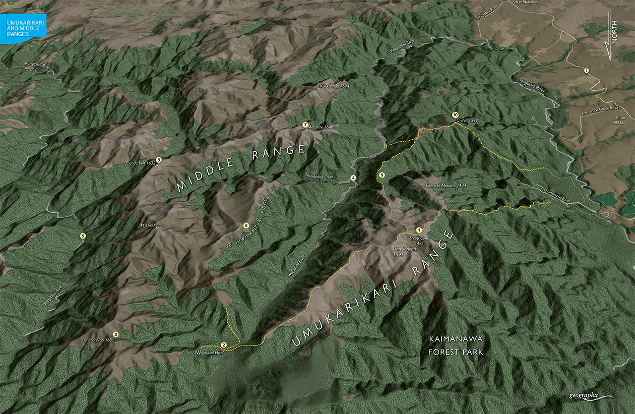
1. Sharp Cone
The Umukarikari Track climbs through beech forest onto the open, undulating tops of the Umukarikari Range. Following a poled route, a gentle ascent leads to Sharp Cone, 1481m, the first prominent peak of the range, then on to the high point of Umukarikari, 1591m. From here the Waipakihi Valley stretches out before you, while further east are the seemingly endless ridges of the Kaimanawa and Kaweka ranges. Under heavy winter snow, the Umukarikari tops have good potential for ski touring. On a bleak day, however, travel along the exposed range can be a slog.
2. Waipakihi Hut
Waipakihi Hut lies in the headwaters of the Waipakihi River and is reached after the 4-6hr tramp over the Umukarikari Range. One of five huts in Kaimanawa Forest Park, the 12-bunk Lockwood hut makes a good overnight destination or a base from which to embark on longer trips.
3. Junction Knob
From Waipakihi Hut, a well-defined route leads up to Junction Knob, 1605m, a prominent knoll at the northern extent of the Middle Range. On a good day, outstanding views unfold in every direction. South of the knob, unmarked but easy tops travel traverses the Middle Range.
4. Waipakihi River
This is a pleasant river valley with many flats, ample camping spots and easy travel. From Waipakihi Hut, follow the river down to the track over Urchin, or carry on down to Waipakihi Road.
5. Rangitikei River
One of the North Island’s premier wilderness rivers, the Rangitikei drains a large part of the central Kaimanawa Ranges. No huts and few tracks ensure trampers probe its emerald-green depths only infrequently. Old tracks lead down to the headwaters from Junction Knob.
6. Te Hiwiokaituri Ridge
This ridge offers good travel from Pt 1660m on the Middle Range down to the Waipakihi Valley, although tight pole beech makes for slow going in the first part of the descent from the bushline.
7. Motutere
Motutere, 1646m, lies on the western fringes of the Middle Range and can be reached on a route through bush from the Waipakihi Valley. From its summit, easy tops travel leads along to Thunderbolt and beyond.
8. Thunderbolt
One of the higher peaks of the Middle Range, 1663m Thunderbolt lies at the head of Thunderbolt Creek, a major tributary of the Waipakihi. Just south of Thunderbolt, experienced trampers can drop down into a bush saddle, where an unnamed tributary offers reasonable access into the middle reaches of the Rangitikei.
9. Urchin-Umukarikari Track
This track, recut in recent years after being decimated by Cyclone Bola in the 1980s, connects Urchin with the Umukarikari Range.
10. Urchin
At the base of the Urchin Track, there’s an excellent campsite beside the Waipakihi River. From here, the Urchin Track climbs stiffly for 300m until the bushline, where a poled route leads for 2km over the tops of Urchin, 1392m, then down through beech forest to a car park on a branch of Kaimanawa Road.
