
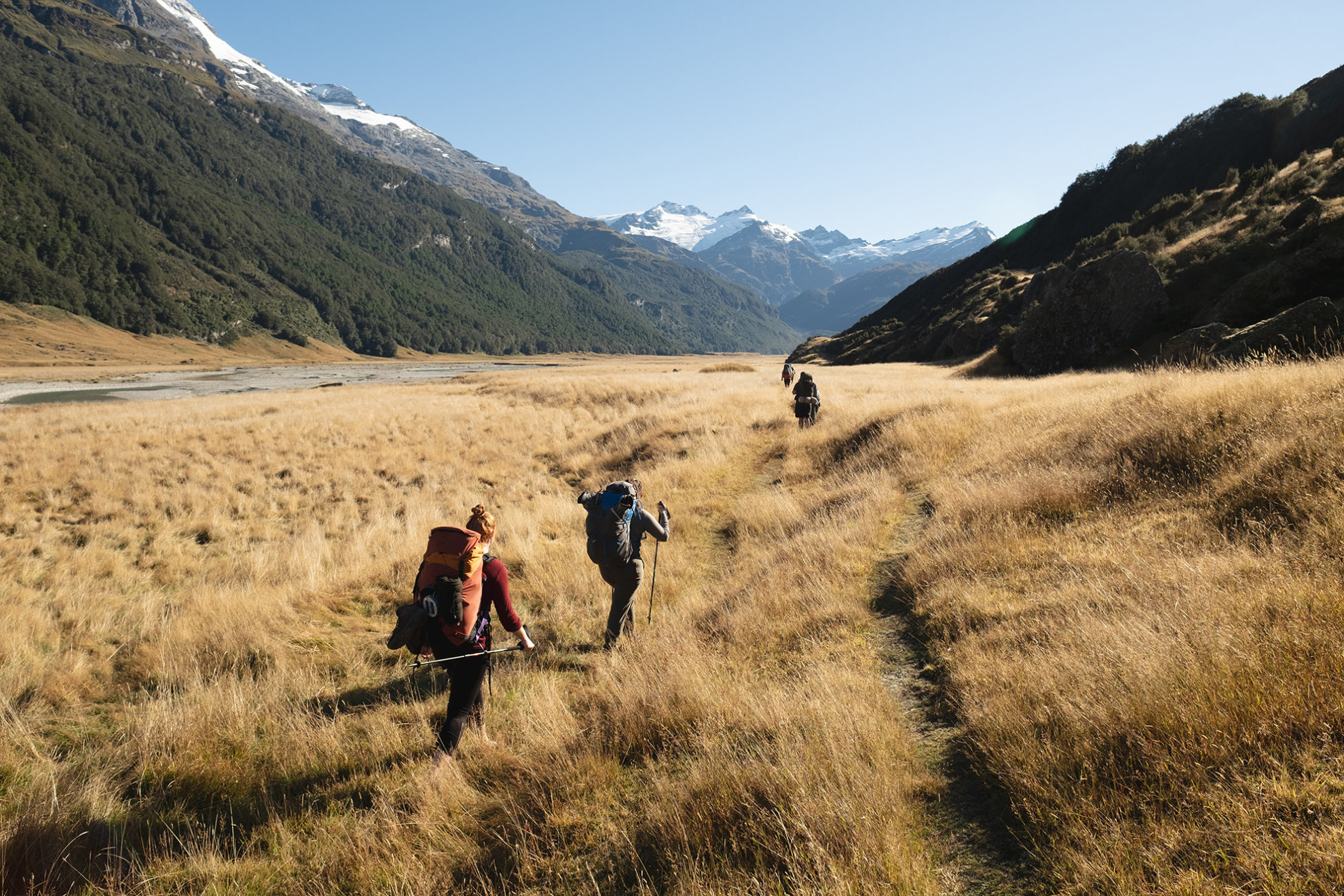
With easy kilometres of broad valley hiking ahead, we traded track markers for a pick-and-mix combination of the marked route, a 4WD track and river bed as we cut north across the foot of Pikirakatahi Mt Earnslaw. It was easy, joyful tramping.
The beech forest beneath Twenty Five Mile Spur marked our first real incline of the day. With roughly three hours to go, I traded water-logged sandals for dry socks and boots – glad to have read bloggers’ warnings of bogs and boot-soaking stream crossings.
By the time we reached Shelter Rock Hut the sun had been replaced with clouds. A fire blazed in the full hut as we wound down, shared Easter eggs, and turned in early in our private room.
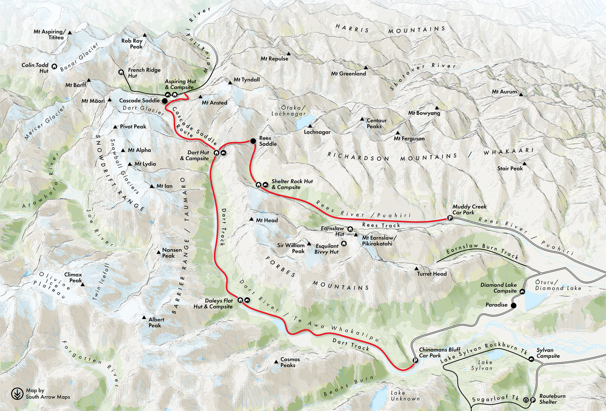
Those who have walked the Rees–Dart before will know how success depends on the weather. They will also know that, barring the day walk to Cascade Saddle, the route over Rees Saddle is the most spectacular section of the track. I chatted with the ranger, who said the summer had been the driest he could remember; this was the first rain in weeks. With an improving forecast, we planned to leave shortly before lunch, but by mid-morning itchy feet dragged us onto the track, heads bowed against the rain.
A year ago, several of us had walked Gillespie Pass together – a trip pestered by injuries, rain, exhaustion, and a day of cabin fever at Siberia Hut. The day over the pass was my hardest so far, and trepidation grew as we followed the Rees River to its beginnings at the valley head. Today, however, the sun began to peek through the rain clouds, and within an hour we were grunting up towards the saddle beneath a blue sky, a rock wren cheering us on from its craggy nest.
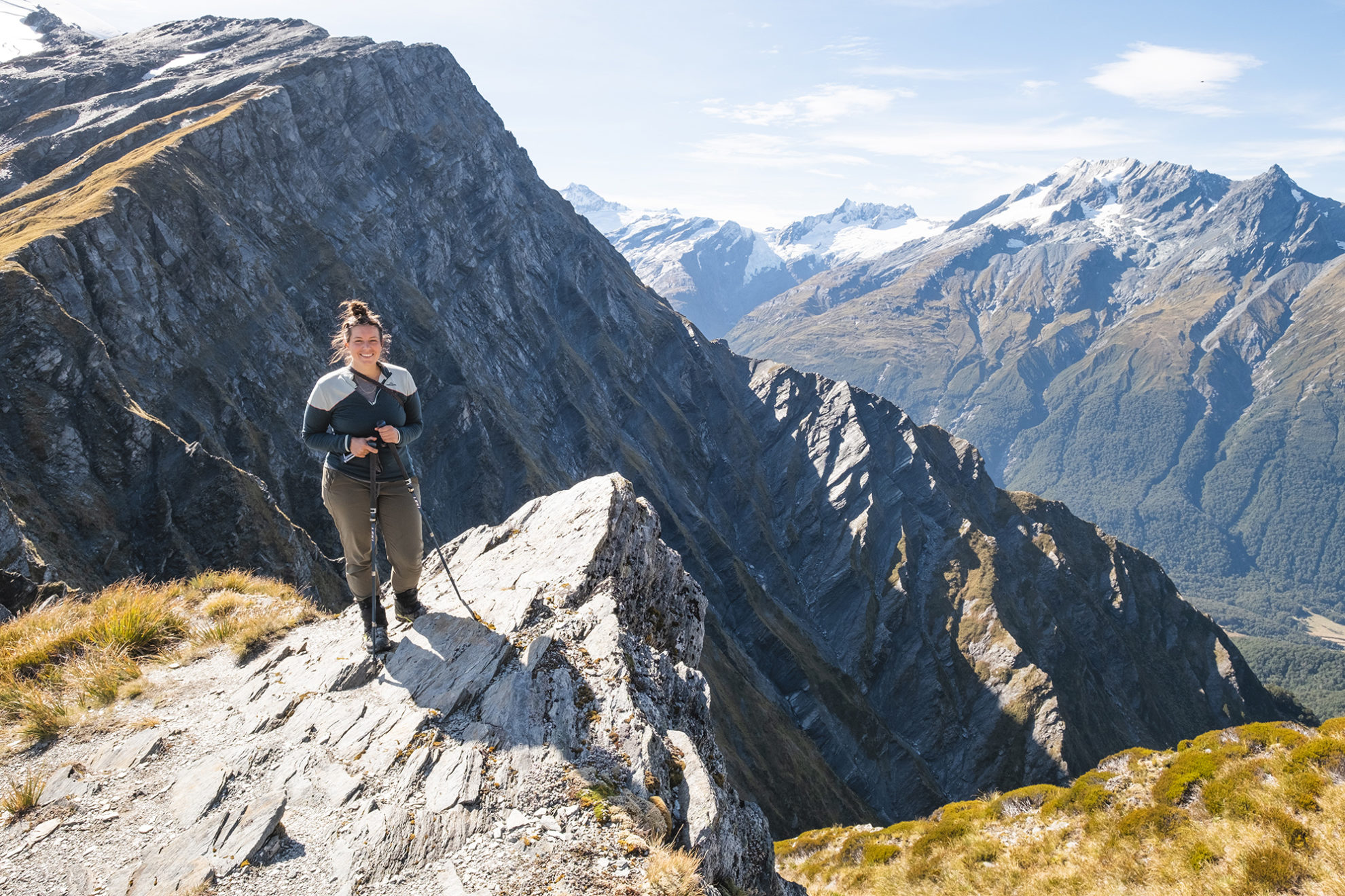
With Gillespie still on my mind, I was surprised to hear howls of delight, just 15 minutes after we started the climb, as the first of our party pushed over the pass. At the top were views of mountains in every direction. Snowy Creek cut through the valley below, small tarns glittering at its edges. We stopped for lunch and took in the moment, cheeks sore from smiling.
The descent to Dart Hut earned its place among my favourite sections of track in Aotearoa. The route follows the true left of Snowy Creek, the claustrophobic slab walls of grey schist becoming increasingly steep and the track increasingly precarious, with the glaciers of Mt Edward shining in the distance. There is exposure here, moments where misjudged manoeuvres would see you at the bottom much quicker than planned.
After an hour of sensational valley clambering, the track crosses a seasonal bridge before plummeting nearly 400m to the Dart Valley. This, and the phenomenal views of glacier-capped Mt Edward, are reminders of why most people walk in this direction.
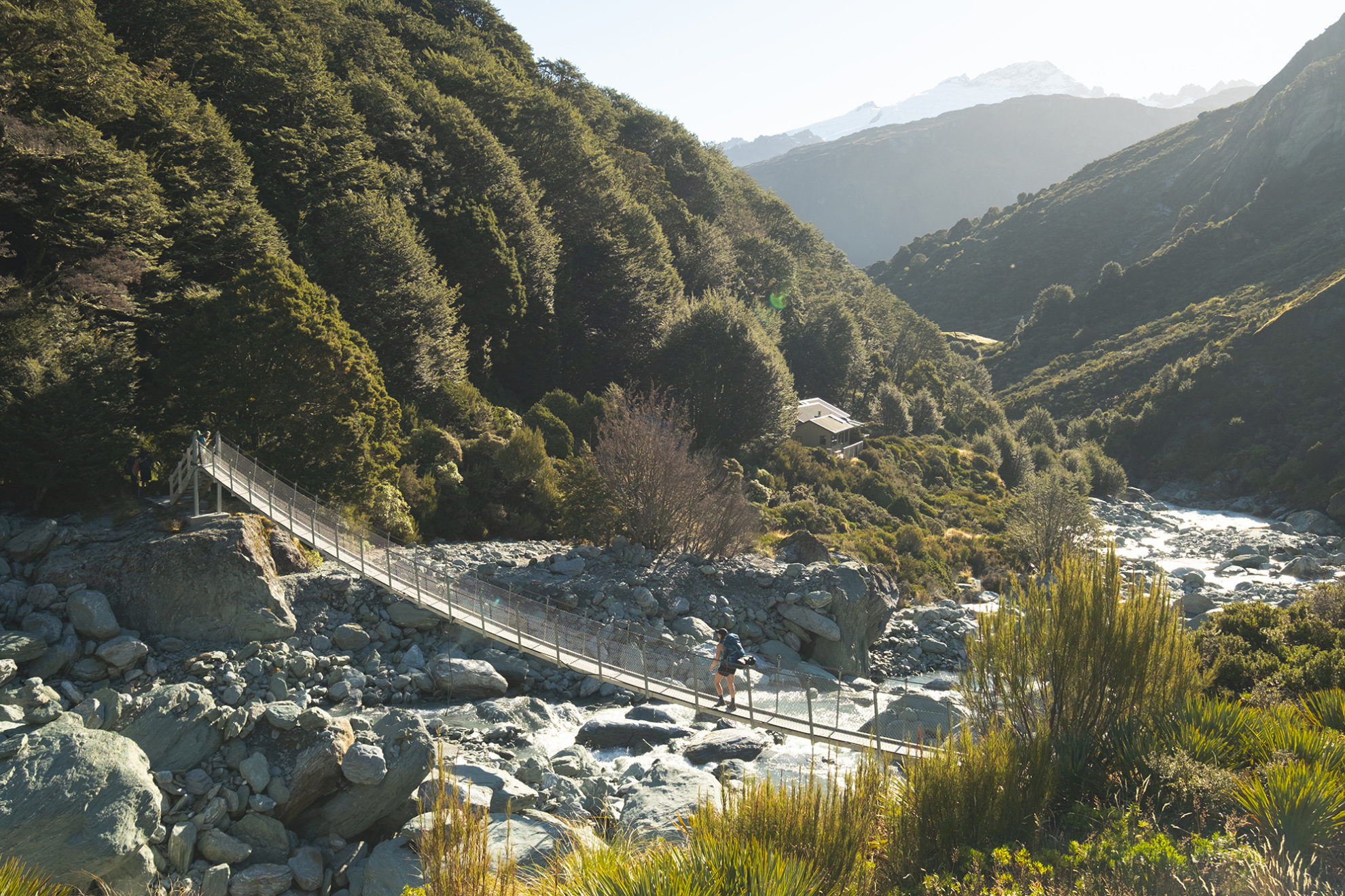
We reached Dart Hut in the golden light of afternoon and spent a blissful half hour cooling down on the banks of Te Awa Wakatipu, Dart River. It’s glacier-fed and I could only handle dipping my limbs, but a few of our party submerged themselves under the painfully cold torrent.
The 36-bunk Dart Hut is easily of Great Walk standard, with multiple bunk rooms, a sizable living area and a deck. It sits on a sunny perch overlooking the river. Talk to anybody at the hut and you’ll hear just two words: Cascade Saddle.
The 1524m saddle is renowned for staggering views of Dart Glacier and Tititea Mt Aspiring, but also for its tramping fatalities. It makes a popular out-and-back day trip from Dart Hut, and links the Dart Valley with Aspiring Hut’s doorstep on the floor of the West Matukituki Valley. The Dart approach provides the views without the exposure and danger of the West Matukituki approach.
We couldn’t imagine how Cascade Saddle could trump Rees Saddle, and like kids discussing crushes at a sleepover, we lay on our bunks rating and ranking our favourite tramps.
Many of New Zealand’s classic tramps were name-dropped – the Milford, Routeburn, Gillespie Circuit, Lake Angelus – but all agreed that the Rees–Dart might top the list. With a 10-hour day ahead, we set alarms and tried our best to ignore the butterflies.
We made breakfast by torchlight, careful not to trip over trampers asleep in the kitchen of the packed hut. There were plenty of campers too, and we shuddered at their nylon and ice cocoons as we passed en route to the saddle.
DOC estimates 8–10hr for the 20km return trip to Cascade Saddle, and we carried as little as possible, sharing packs, food and water. Initially, we were under the blue light of dawn, navigating icy river crossings and shivering in the shadow of the mountains. The valley floor was frozen solid and the rocks were covered in invisible ice that threatened an early end to our day trip. One of our group did take a fall, landing chest-first on a large rock midstream in a tributary. He stayed down long enough to give us all a sobering shock but remained dry and only suffered bruising.
The sun finally played ball, lighting up the peppermint pastel carpet of moss bordering the track as we rounded the foot of Mt Edward. The landscape feels similar to Aoraki’s Hooker Valley, a humbling glacial playground reduced to rubble over millennia. Eerie teal-coloured pools of glacier melt contrast with the metallic valley floor, while chunks of blue ice cling precariously to clifftops hundreds of metres above. If Rees Saddle made us feel small, this new landscape made us feel tiny.
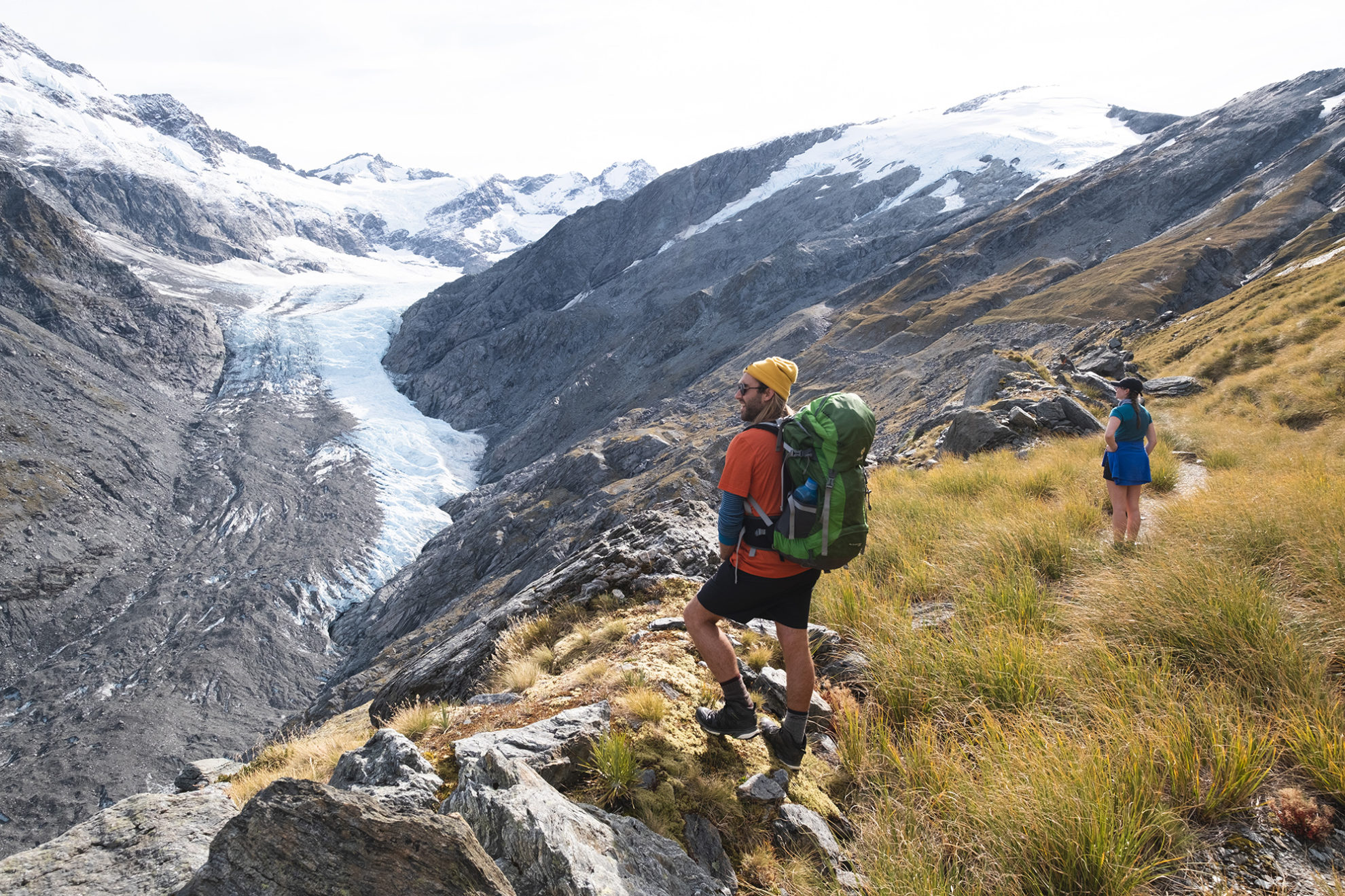
After three hours at a solid pace, we stood at the base of the climb, craning our necks at the poled route above. With much of the track crossing active slips, our ascent was slow and careful, and we turned often to view Dart Glacier, which transformed from gritty grey to pure grandeur as we gained altitude. It was my first experience of viewing a glacier from above, and I was pinching myself.
At the 1400m mark the track sidles behind a natural battlement of rock for 500m before the final climb to the saddle, and the snowy caps of the West Matukituki Valley began to come into view.
The saddle is beautiful, otherworldly, and boy did we score a day for it – high cirrus, blue sky and sunshine. From there a narrow track continues south, flirting dangerously with the deathly drop to West Matukituki Valley, a kilometre below. The lofty summits of Rob Roy and Tititea dominate the skyline, glaciers pinned to their chests. Turn around, and there is Dart Glacier, snaking down the valley under the nose of Mt Liverpool. In every direction, something jaw dropping.
I could have happily spent the day on top of the world, but with the hours ticking on, we explored a section of the saddle above Heads Leap and lunched in the sunshine. A visiting kea gave us the cherry on top, posing against a backdrop of snow-capped peaks. Our senses brimming, we began the walk back to Dart Hut, arriving after a nine-hour day, exhausted but enthralled.
The final two days felt like a come-down period – a time to reflect and process the mind-blowing scenery we’d been through. Both were gorgeous in their own right – wide valleys of golden tussock, mossy beech forest and exposed slips – but our standards had been pushed to lofty heights and our senses were frazzled. We wondered aloud if tramping had been ruined for us forever. We were walking through stunning wild country, and we couldn’t keep our thoughts in the present.
Daley’s Flat Hut was our final stop. Overlooking a sweeping bend in the Dart River, it’s a pleasant enough spot apart from the sandflies. Over dinner, we all agreed it had been a pearler of a trip. The weather and wildlife had pulled one out of the bag, we’d avoided injuries and been treated to the best views of any track I’ve walked. The Rees–Dart has two saddles that surpass the Milford, valleys to rival the Routeburn, and glacial landscapes that would be at home in Aoraki National Park. If it’s not at the top of your list, put it there.


