Harbour Cone, Dunedin
The purchase by the Dunedin City Council of a 328ha farm surrounding the visually impressive Harbour Cone has given a boost to walking opportunities on Otago Peninsula. I recently used an unplanned morning off work to suss out some new tracks and revisit some old ones.
Leaving from a sign on Highcliff Rd, 3km past the Pukehiki church, I descended into Smith Creek, following marker poles. The route soon splits, with the left hand option dropping a little further before slogging up 140m towards Camp Road. It then sidles towards the ruins of Larnach’s model farm and carries on to join Camp Road. Apparently, Larnach used this farm to experiment with some innovative farm practises. I’m hoping one day there will be some interpretative material here to say just what they were. From here, those with time and a few dollars in their pockets can wander over to Larnach Castle.
Larnach’s self-deprecating name for his mansion was the Camp, hence the road name. It’s also possible to drop down the unformed portion of the road to the harbour side village of Broad Bay, where you can visit the first house built by the first Sir James Fletcher, on his way to building an empire, and then follow Portobello Rd to rejoin the tracks at Bacon St in Turnbull Bay.
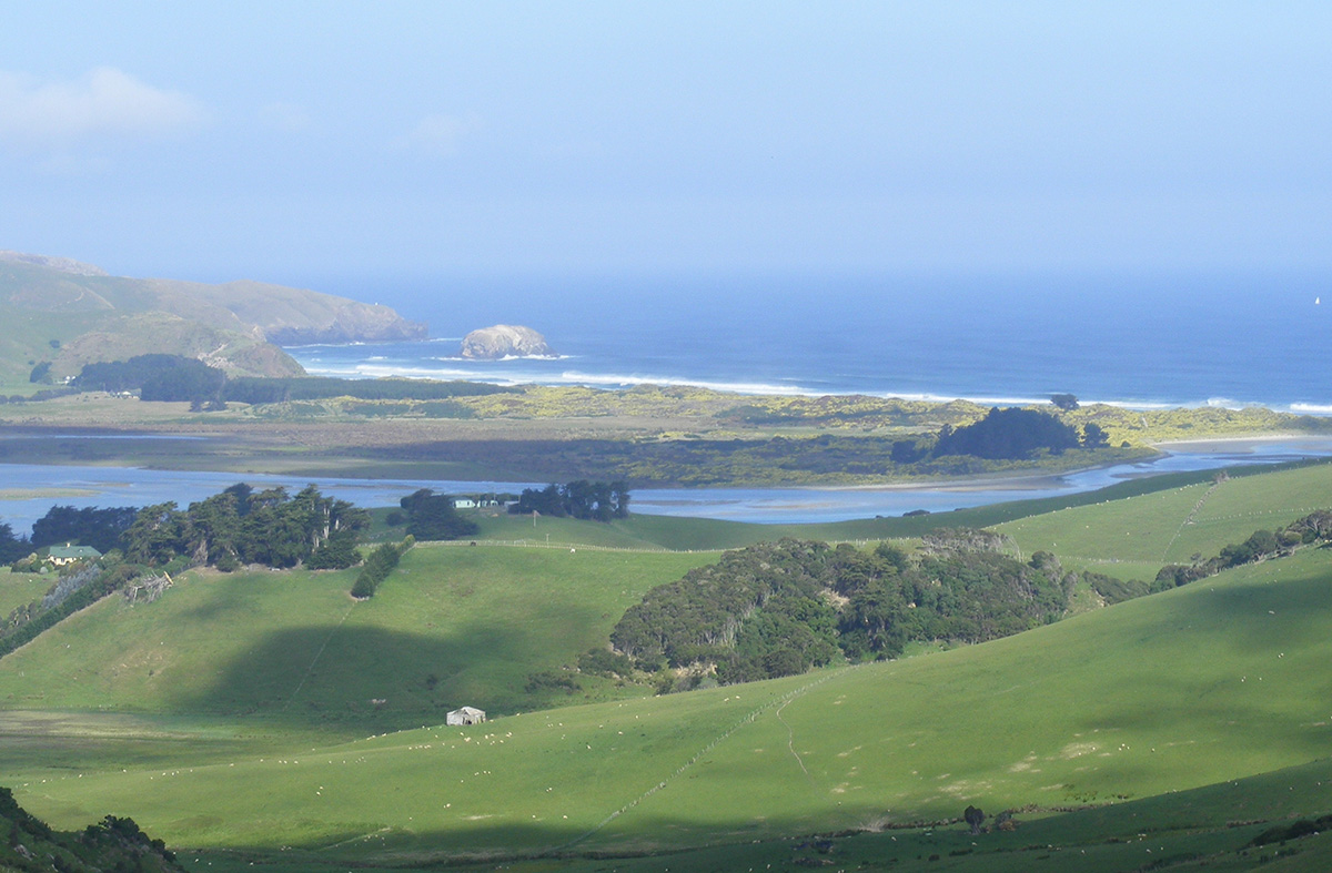
I chose to retrace my steps to Smiths Creek. The views on this section are outstanding and justify the detour. With Harbour Cone straight ahead, I could see Aramoana and the mouth of Otago Harbour to the left, and Hoopers Inlet and the peninsula’s seaward beaches to the right.
As I dropped down towards the junction, a paradise duck tried the old broken wing decoy trick on me. I looked the other way, hoping to spy the nest but without success.
Twenty years ago, veteran recreational activist Bruce Mason led a cunning campaign that pushed the Dunedin City Council to mark walking routes on nearly 20 unformed legal roads. The reaction of some farmers, who’d been using the roads, gratis, for years, was somewhat overcooked. Others were more conciliatory, and so in some cases access was negotiated that suited both walkers and farmers better; in the majority, we walk the road line.
These hidden treasures now form a really useful network, but as I turned into the track that is an extension of Bacon St I was reminded that the old surveyors had no respect for topography. From near sea level, I now had to climb 160m at a gradient approaching Baldwin Street’s. While there’s no getting away from having to gain height, the new routes do offer some gentler alternatives.
Crossing Highcliff Rd, I took a newly marked route that leads directly to the summit of Harbour Cone. If Bacon St Track has exhausted you, it’s possible to walk along the road for a bit over a kilometre to the car, although a better option is to rejoin the tracks at a sign nearly halfway there and take the short climb to a ridge top with great views on the coastal side.
For years, Harbour Cone, a landmark featured in paintings by Grahame Sydney and Robin White amongst others, has been off limits to walkers. The summit boulder fields and the shape are reminders of its origins as a volcanic cone, an offshoot of the volcano that formed the peninsula and harbour. Lanarch Castle was now clearly visible behind its protecting trees, while out towards the coast, Mt Charles, the peninsula’s highest point, was swathed in easterly fog.
Descending off the cone, I came to another steep legal road track that descends to Hoopers Inlet. It’s got a fixed rope at one point, and its only redeeming feature is that it used to provide the only public access between a couple of nice spots. The council’s purchase means that an alternative and more pleasant route now arcs around the side of a gully.
But that could wait for another day. Ten minutes in the other direction brought me back to my car.
Note: Closed for lambing September 1 – November 1