After a leisurely (2¼hr) drive from Nelson we arrived at Marfells Beach, which lies at the southernmost extremity of the Cook Strait. It is here, near Lake Grassmere, that the Government was looking to relocate the ferry terminal from Picton but has only recently decided to ditch the controversial proposal, much to the relief of many.
Earlier this year local residents were terrified by a 6.6 magnitude earthquake followed by large aftershocks which hit the nearby townships of Ward and Seddon very hard. Evidence of this could be seen at Marfells Beach where the access road had been closed for several weeks due to large chunks of siltstone that had broken away from the cliffs and blocked the road. Services were also damaged. A nearby farmer said the shake knocked him off his feet and he was suddenly on all fours. There was no warning – ‘boom!’ and it was here. His house was shaken like a rag doll. The aftershocks appeared to be over by the time we visited, so we were spared any such dramas.
So, on an outgoing tide, seven of us left the camp ground at 8.30am to follow an unmarked route along the coastline to the first point of interest at Mussel Point, where the London Hills fault enters Cook Strait. We carried on along the foot of the cliffs but, from here, Cape Campbell is visible about 5km away.
The going is straightforward once the tide has receded; being on a mixture of soft sand and small stones, with some curious siltstone outcrops providing added interest.
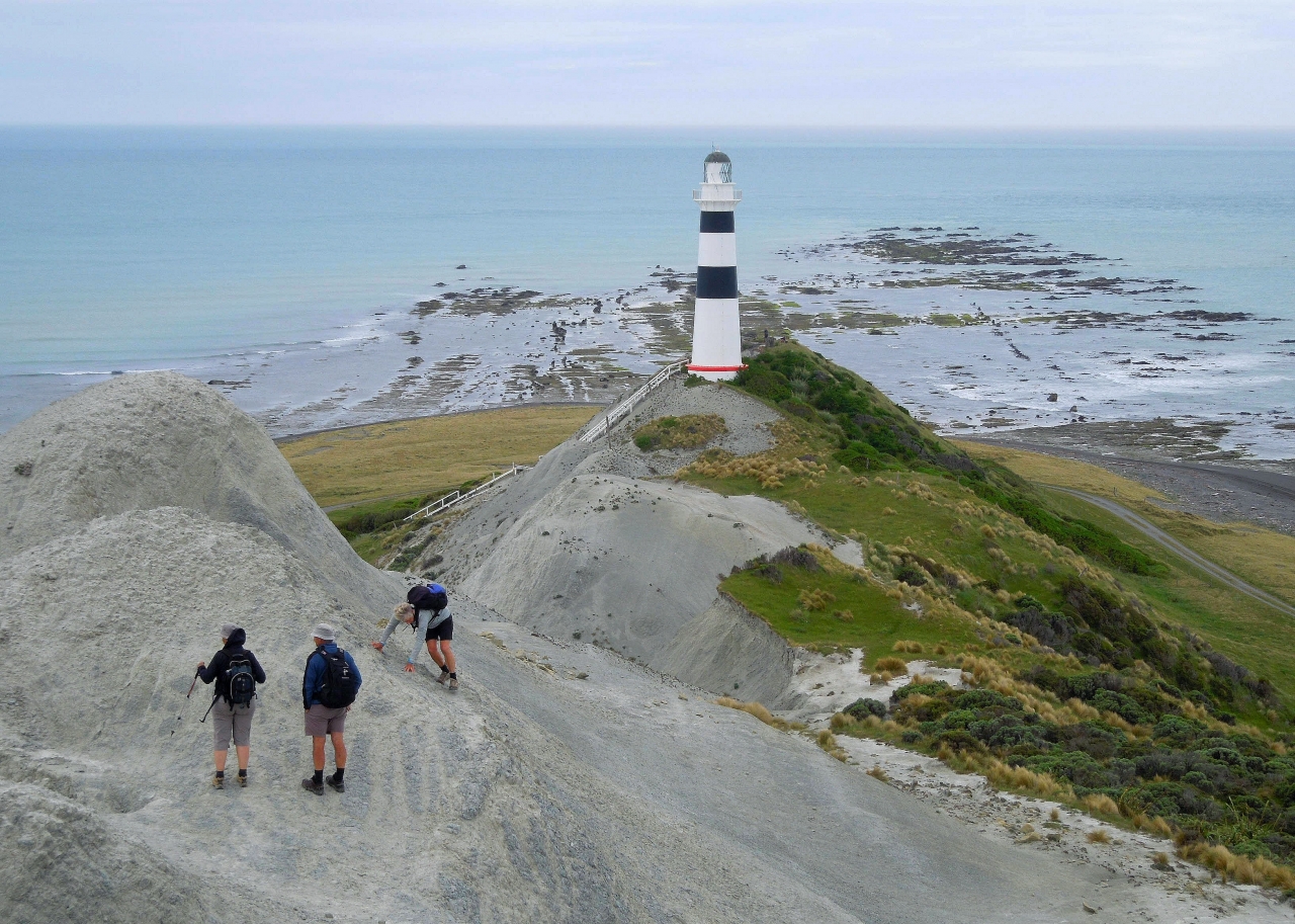
By 10am we had reached the cottages below the lighthouse where we stopped for morning tea and a general fossick. The historic lighthouse is the main feature of the cape with its wide black bands making it more visible against the white cliffs behind. The present 22m cast iron tower replaced an earlier wooden one whose light first shone in 1870. In 1986 it was automated and de-manned and is now controlled from Wellington. Following the big earthquake it was reported that the ground under it had shifted 18cm further west but we could see no sign of that.
We scrambled up the narrow siltstone ridge above the lighthouse going as far as a radio transmission mast and passing on the way several noticeable longitudinal earthquake-induced cracks. Also close at hand were marker posts for the privately owned Cape Campbell Walkway, which is a four-day homestay trip starting in Ward.
There are great views from the ridge where you can easily see the southern shore of the North Island just across the water, while down below are extensive reefs visited regularly by crayfishermen on their quad bikes. Strong winds on the ridge are a regular occurrence.
Although the lighthouse can be reached by a private 4WD road on the southern side of the cape, the coastal walk from Marfells Beach to the north offers plenty of interest with its fascinating geology and the prospect of seeing some seals and dolphins. It is best done on a low midday tide as high spring tides can block access around the foot of bluffs.
-David Blunt

34 years of inspiring New Zealanders to explore the outdoors. Don’t miss out — subscribe today.

Questions? Contact us