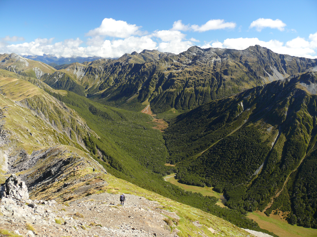
Zampa Tops, Lewis Pass National Reserve
Surrounded by the mellow valleys of the St James Walkway, Mt Zampa (1710m) sits right on the Main Divide. In a basin on its eastern slopes is Zampa Tarn, an idyllic place to camp.
There are various ways to get to the Zampa tops. Henry Saddle from a side creek off the Maruia River Right Branch is a favourite. But there are other approaches, such as climbing up and following the Main Divide from Ada Pass, enjoying the ramble over classic tussock tops.
One of the surprises up here is the spacious views. From Pt1681m, the Ada Valley looks like an idyllic parkland with the Spenser Mountains as a backdrop. From a little further south, the Henry River stands out similarly on the other side of the Divide with the rocky skyline of Philosophers Knob giving it an edge. Across the Maruia, sharp runnels scratch their way off the ridge and through the beech forest. Even from the tarn there are views. What a place to be.
Access From the Lewis Pass Road follow the Saint James Walkway to the swingbridge over the Maruia River right Branch
Time Allow a day to the tops and tarn and a day out
Map BT23
Garden of Eden Ice Plateau, Adams Wilderness Area

Imagine a set of large glacial névés and easy mountains sitting right in the middle of one of New Zealand’s wilderness areas. Still not tempted? Consider the names: Garden of Eden, Garden of Allah, Beezelbub Glacier, Angel Col, Satans Saddle. Admit it, this is an irresistible trip.
The tramping isn’t easy, though. Starting from the dun grasslands of Mid Canterbury high country you’ll need your gravel bashing boots on, and your river crossing instincts tuned in as you head up the barren Clyde Valley aiming for the snowy ramparts ahead of you.
When you finally pop over the last slope above Perth Col and the white blanket of the Garden of Eden runs for kilometres ahead of you you’ll feel like letting out a whoop or two. Adams Col is a legendary place. Mt Cook in one direction and the Tasman Sea in another. If you’re lucky, the weather will be kind and you can sleep out on the sun-warmed rocks.
There’s no easy option to complete your crossing, but one of the easier ones would be to tackle the Perth. You’ll learn about fortitude amongst the big boulders and thick bush of the Upper Perth. It isn’t fast travel, but it makes Scone Hut and the track all the way out to the road that much more enjoyable.
There are a lot of possible routes onto and off the Gardens, so grab a guidebook and get exploring.
Access Clyde River can be accessed from the end of Hakatere Potts Rd
Time 7-8 days
Map BX18, BW18, BW17, BW16
Lake Sylvester, Kahurangi National Park

Lake Sylvester, perched in the rolling tussock tops of Kahurangi National Park, is in a world of its own. Easily accessible from the Cobb Reservoir up a well-marked track, the lake is one of several in the area, all with their own appeal. It is never hard to find a quiet isolated corner to enjoy, and in December and January the area is renowned for its alpine flowers with whole fields of showy yellow bulbinellas waving in the breeze.
The track leads through open beech forest, where kaka and kea are often heard, and on the tops it may even be possible to see the odd rock wren bobbing on the boulders, particularly near Iron Hill.
The 12 bunk Sylvester Hut is sited at the bushline and provides a great base to explore from.
Lake Sylvester is one of several lakes and tarns in the Cobb Catchment that once had controlled outlets. Today, the water levels manage themselves, and you have to look for signs of that history. Beyond Lake Sylvester lies Iron Lake, and higher again, the blocky bluffs of Iron Hill rear up as a backdrop, a fantastic Cobb viewpoint and a place where iron-stained rocks are scattered with seams of pure white quartz.
The whole area is accessible, magical and full of nature discoveries. You just have to go there.
Access Drive to Cobb Reservoir dam from Upper Takaka. A track leads to the Sylvester tops
Time Allow 2hr to the lake
Map BP24
Dasler Pinnacles, Ruataniwha Conservation Park

Dasler Pinnacles are an incredible view from the base of the Hopkins Valley. Sheer-sided cliffs lead up to narrow twin summits. The North Ridge, the easiest way up the mountain, looks like it falls away at a steep angle. It’s an impressive and quite intimidating sight, especially if you’ve come to climb it for the first time.
In the Barron Saddle -Mt Brewster guide book, author Ross Cullen describes the Dasler Pinnacles as being ‘among the most striking features’ in the Hopkins Valley, and the North Ridge a ‘popular introductory climb’.
From the valley floor the ridge looks anything but introductory. But don’t worry about that, just focus on the steep slog up through the bush to the cosy Dasler Bivouac, set right at the top of the bushline and two hours from the start of the climb.
Appearances can be deceiving, and it is certainly the case with the North Ridge. Given an alpine grade of 2-, the rocky ridge can be easily scrambled direct to the 2315m summit. A head for heights is required but climbing gear isn’t, although a pair of crampons and an ice axe may come in handy if snow is frozen on slopes leading up to the start of the ridge.
A great weekend trip.
Access From the end of Lake Ohau Rd
Time 2-3 days
Map BY14
Cascade Saddle, Mt Aspiring National Park
If you’re fit and experienced, this is a must-do trip. The mountain grandeur here is dramatic, the valleys are huge, the huts historic, and if you’re seeking solitude or saving money, a smattering of rock bivouacs and a plethora of riverside campsites are on offer.
From Aspiring Hut, the treacherously vertical Cullers Route takes a minimum of three hours to reach a pylon, where you crest the alpine world of Cascade Basin. Nearby is a sheer drop where a small stream plummets down to the valley floor, 1000m below.
Those intrepid souls who have camped here will warn you of the resident kea population which are territorial rascals, ripping tent fabric and stealing camping gear. DOC has positioned a toilet here, but this is a very fragile ecosystem better suited to day-trippers.
To the north, some 15km distant, is the perfect pyramid of Mt Aspiring.
For those walking the Rees-Dart circuit, a side-trip to Cascade Saddle is mandatory, and takes about four hours from Dart Hut. Boulder-hop two steep, rocky side-streams, then trudge up the desolate Dart Valley. Two hours following monumentally large cairns, then the ground trail drops onto the level pan of moraine gravel. The terminus of the glacier is silty black where the rotten ice crumbles into the river, glacial green.
A solitary orange marker pole signals the slow slog to Cascade Saddle, some 400m above. A sudden crack of thunder may turn your head. It will be a snow avalanche falling off Mt Edward.
The full crossing from Dart Hut to Aspiring Hut takes about ten hours, and requires good visibility and much care.
Access: Short route: From Raspberry Flat car park at the end of Wanaka Mt Aspiring Road. Long route: From the end of Rees Valley Road
Time Two days from Rees Valley Road-end; 7hr from raspberry flat car park
Map CB10, CA10
Motu River, Raukumara Forest Park, Bay of Plenty

The Motu River begins life on farmland near the Gisborne-Opotiki Highway, but soon pours into dense forest, cutting angles through all points of the compass as it winds sinuously through some of the North Island’s most torturous country – the Raukumara Ranges. During its long course, the Motu drifts through high-walled canyons, swirls in deep pools, and plunges over cataracts and staircases.
This is one bucket list trip you’ll get wet on. Although the rapids are no harder than grade 4, the river’s remoteness and inaccessibility ensure it is suitable only for experienced paddlers or those on a 3-4 day guided trip.
In the Upper Gorge, the river narrows to plunge through Bullivants Cascade, the first grade 4 encountered. Soon after is The Slot, a maw of white water where the Motu slews sideways over a narrow drop. At the end of the Upper Gorge the river exits a high-walled ravine onto the flats of Otipi. The second gorge, Te Paku, is less boisterous but has more appealing scenery with verdant forest. Lower down, the occasional nikau palm signals the river’s descent into lower climes.
Finally, after gathering all of its tributaries together, the Motu forgets the exuberance of youth, and embraces old age. Its midriff expands; the rapids are fewer and subdued. By the time the Motu passes under the SH35 bridge, the grand old river has lost its urgency – but earned your respect.
Five Passes Tramp, Mt Aspiring National Park
In many ways, this trip is summer tramping perfection. Rusting mountains, broad tussock valleys, alpine lakes, schist gorges and five passes are just some of its diverse features. The Five Passes tramp offers a somewhat gentle introduction to wilderness: grand country where you camp at will and probably meet no one else.
Beginning from the Routeburn Track, the 5-7 day tramp crosses the first pass, Sugarloaf, into the Rock Burn, where the formed tracks end and a lightly-trampled route begins. At the head of the Rock Burn is pass two, Park Pass, an idyllic place to camp during fine weather, with views of the Darran Mountains and Hidden Falls Creek. After a descent into the creek, follow it into the headwaters at Cow Saddle, where the first of the ultramafic rock bands lend the country a rusty appearance. Fiery Col, the fourth pass, takes its name from this characteristic hue. High in metals such as magnesium and iron, the red ultramafic rock stunts plant growth, too.
Now deep in the heart of the wild country, trampers will feel a sense of remoteness as they tramp over the alpine wetlands of the Olivine Ledge, along to the stream draining the Fohn Lakes. A climb to the lakes leads to another fine campsite, before the final pass, Fohn Saddle, leads into Beans Burn. As with all the other valleys, there are no huts here, but a good rock biv exists near the headwaters. A track at the lower end of Beans Burn leads to the Dart Valley and the trip’s end.
Access From Routeburn Rd, at the start of the Routeburn Track
Time 5-7 days
Map CB09, CA09, CB10
Stafford Bay, West Coast

West of Jackson Bay the road stops and nature takes over. It wasn’t originally meant to be that way. In 1875 grand plans were laid and 12 families moved to the Smoothwater River to break the land in. But it broke them and two years later they had all left. During this time, a benched track was built into the Smoothwater Valley and the track to Stafford Bay now follows this for some of the way. A very easy hour sees you into the Smoothwater. No big climbs, just lush forest, gorgeous creeks and birdlife with you all the way.
From here there is a loop in along the track to Stafford Hut (6 bunks) and out along the coast, but you need to get the tides and sea conditions right to make it practical.
The crossing over to the Stafford from the Smoothwater is on a less developed route, bolstered by sections in the rivers and streams along the way. You can smell and hear the coast on the last kilometre to Stafford Hut. It feels like reaching the end of the earth. This is a place with mood and attitude, saturated in the sea. Rich forest, and clear fresh water in a river that runs out of energy and simply floats its way the last stretch to the ocean. Driftwood, fine shingle beaches and kiekie. This is southern paradise.
Access South from Haast near Jackson Bay, where a DOC sign indicates the start of the track to Stafford Bay
Time 4hr along the track; 5hr around the coast
Map BY10

34 years of inspiring New Zealanders to explore the outdoors. Don’t miss out — subscribe today.

Questions? Contact us


