Known in my youth as the place to go to play at kayak surfing and to today’s youth as ‘the’ place to go for New Year’s Eve, Whangamata suited our end of winter purposes admirably. The camping ground would be uncrowded, the showers hot and the kayaking options were favourable with two ocean beaches, islands, a safe harbour to the north and another estuary at the south end to explore.
As the weekend approached, however, south west winds up to 30 knots developed; hmmm, not so good, but it was a long weekend and everyone wanted to clear out of the city. Plan B bad weather alternatives were plentiful: we could always go for a bush walk, or visit the district’s gold mining museums.
Meeting up for nibbles and drinks on Friday evening we called for an 8am start, to try and beat the wind for a morning on the ocean. Launching from the north end of town in the harbour meant a wee carry of the boats as the tide was low, but meant we avoided the surf break. Cruising past the moored boats and nosing out with the early morning fishermen, the sun shone – there was not a ripple to be seen. The Harbourmaster came alongside to check on our intentions and to ensure we knew the weather forecast. Another group of paddlers, a hardy lot from Taranaki, headed out to Slipper Island, planning on an overnighter there before heading up to Hot Water Beach. We wished them luck, but thought them foolish to even contemplate the 18km run in open sea with the wind due to build.
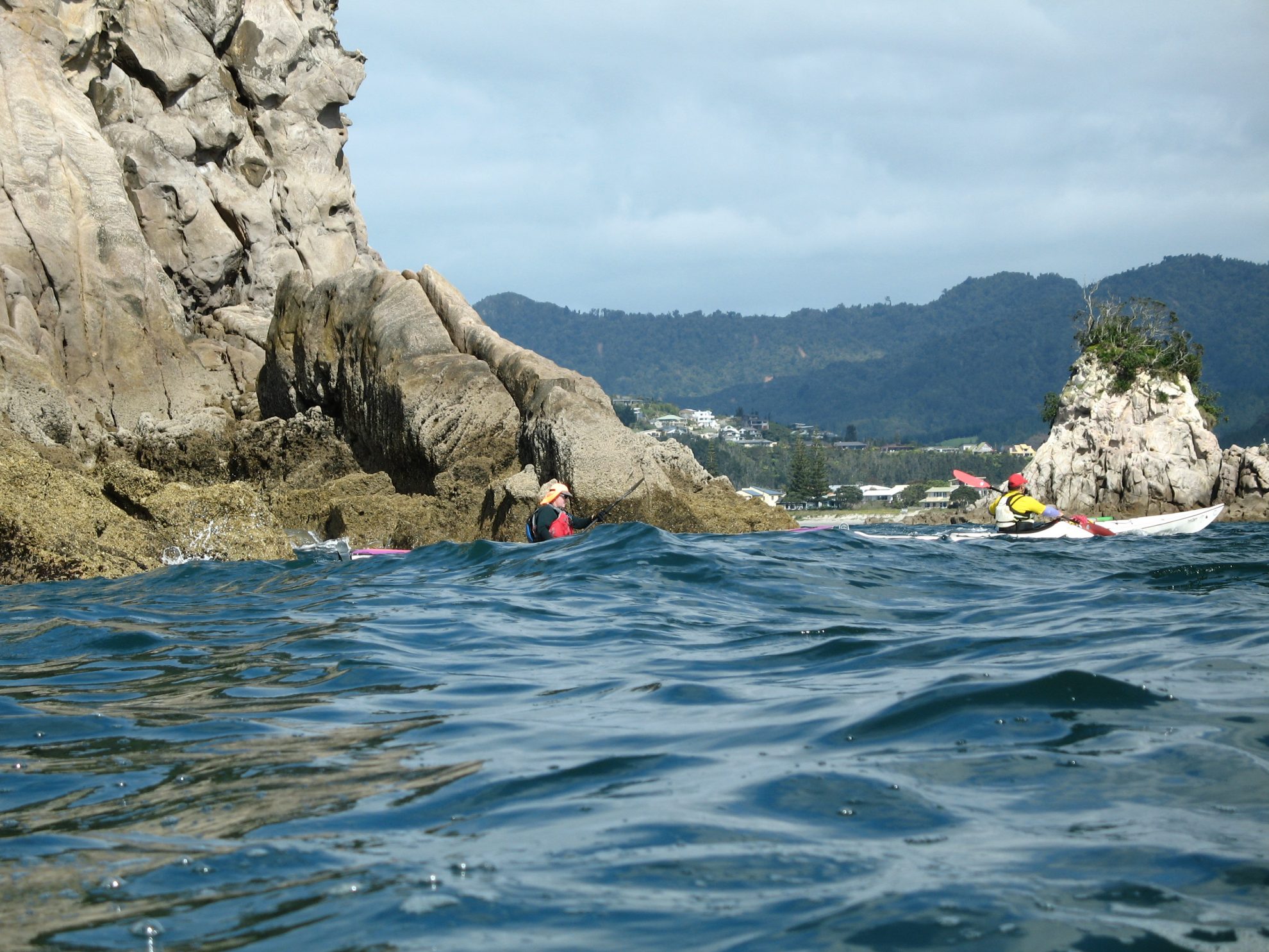
Out on the ocean, Hauturu or Clark Island (accessible by wading at low tide) and Whenuakura Island lured our pod out; a helpful fisherman had told us about a spectacular cave on the island big enough to drive a tinny into. The rise and fall of the swell and the swish of the tide put me off for a bit, but Guy offered his services as escort, and soon we were through the black tunnel and into the light that came through an opening where a large blow hole had collapsed and formed a tiny sandy beach. Trees were growing all around, leaving a circular view of the sky. Magic!
With a headwind building, we turned to shore, hugging Otahu Beach as we travelled south towards Whiritoa. Paddling close to cliffs is always belittling and inspiring. These were no different. By 11am the wind was whistling and it was time to retreat to the safety of the harbour. Enroute some of the boys decided to do a spot of surfing practise, while we sussed out a lunch spot.
To cap off the day we did a leisurely two hour circuit of the northern harbour. Originally Whangamata was settled by kauri loggers. Prospectors and squatters chasing gold followed, but the town was not officially gazetted until 1873. The early part of the 20th century saw an effort at farming, tough in the wet climate and with limited access. In 1929, forestry was proposed and experimental plantings carried out. In the same year the first sections for beach dwellings were sold.
The forestry experiment was successful and Pinus radiata provided the backdrop and mangroves filtered the mud at the harbour head. Holiday homes have replaced most of the original bachs and our cruise took us past many opulent houses with expansive gardens right down to the water’s edge. As we pulled into the launching site the clouds skittered across the sky, and the wind whipped up another notch. That night’s 50-knot winds tested many tents and one party packed up at 4am. The stalwarts stayed on for a bacon and egg breakfast before turning to Plan B.
We later heard that the fellows whom we considered foolhardy went from their Plan B all the way to Plan E which was a fizz boat ride from Slipper Island to Tairua.
– Ruth Henderson

34 years of inspiring New Zealanders to explore the outdoors. Don’t miss out — subscribe today.

Questions? Contact us


