


- GPX File
- Roys Peak (gpx, yo 12 KB)
- Your device does not support GPX files. Please try a different device.
Roys Peak, The Stack Conservation Area, Otago / Moderate
Think of day walks near Wanaka and Rob Roy Glacier Track immediately comes to mind with its hanging ice and waterfalls, as do Mt Iron and Diamond Lake with their lovely vistas over the region. But the most staggering views of all must come from Roys Peak. It’s more of a grunt than its day-walk competitors and the climb is mostly up a 4WD track, but each time you stop for an intake of air the view gets better and better.
I climbed with my friend Roger and neither of us were feeling our fittest. I was stiff after a four-day tramping trip and Roger had barely recovered from an unpleasant illness which caused his digestive system to ‘up the tempo’.
The track zigzagged countless times; first through farmland and then through a fence that marks the start of The Stack Conservation Area.
Soon after, we passed a young woman who looked like she was really struggling. She was panting heavily, taking slow strides, while her walking partner was waiting 50m ahead. Roger and I looked up at the looming summit, which appeared no nearer than when we’d started, and shared a glance that said: “she’s not going to make it”.
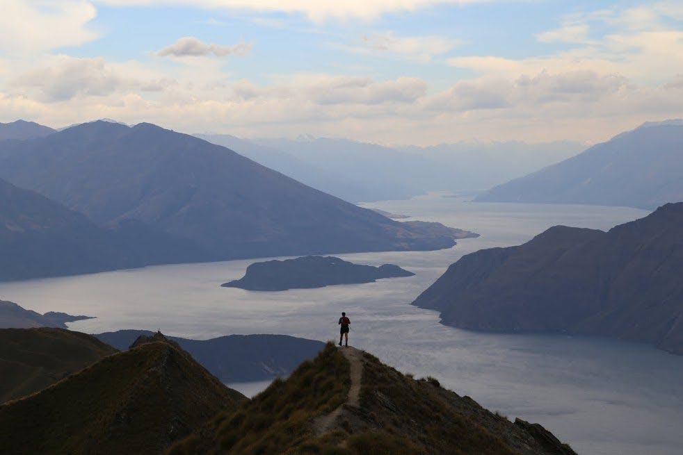
The zigzags continued and I was keeping my eye open for the spot Wilderness photographer Dennis Radermacher found for the cover of the November 2014 issue. When the track brushed the ridge for the first time I spotted it. It’s a spectacular sight with an undulating ridge in the foreground and the northern arm of Lake Wanaka stretching into the distance behind, looking rather like one of the sounds in Marlborough. Our pictures weren’t as good as Dennis’ but we were pleased to have found it.
The track returned to the north-east face again before hitting the ridge once more. It then heads around the back of the hill, but we’d lost patience by now and decided heading straight up the ridge was more fun.
Before long we were standing on the summit marvelling at the sight of Wanaka township with its namesake lake spreading in all directions. Lake Hawea was peeking out in the distance and, though most Mt Aspiring National Park summits were under cloud, we could just about make out Mt Aspiring itself sitting proudly behind the Matukituki Valley. Looking south was a very enticing ridge-line heading towards Mt Alpha – a trip for another day.
It’s a view that, on a calm day, you could watch for hours, especially when the cloud formations are forever changing. But today’s powerful wind meant we couldn’t hang around on the summit for long. We began descending via the main track and were amazed to turn a corner and see the struggling young woman from earlier.
“Almost there,” Roger said cheerily as we passed her.
A little further down we peered over the ridge at the track repeatedly snaking its way left and right to the car park 1000m below. “I’m going straight down,” declared Roger and he slid down the fine scree on his bum. I took a few more photos and met him a couple of hundred metres down. Then we both shortcut it back among the scrub and speargrass until we reached the fence line.
We followed the track after that towards the toilet sitting next to the car park; Roger in more of a hurry than me.
– Matthew Pike
Wild file:
Access: Roys Peak car park, 6km west of Wanaka on Wanaka Mt Aspiring Rd
Grade: Moderate
Time: 5-6hr
Distance: 14.18km
Map: CB12
