Pat Barrett chooses his three best peaks to scramble up
Scrambles, so called because they require both hands and feet to enable progress, and perhaps a few basic rock climbing moves, are not always without some risk. Though not technically described as climbing, they require sound judgement, excellent fitness, and a good eye for the route and any weather conditions which may threaten a safe return.
There are numerous routes for trampers to scramble up, here are three of the best.
Mt Ngauruhoe, Tongariro National Park
Located on the Central Plateau of the North Island, Ngauruhoe (2287m) inspires all-comers to climb it as a diversion from the Tongariro Alpine Crossing. The scramble to the summit is, as might be expected, a full-on hands and feet total immersion in a battle with steeply angled scoria taking between 90 minutes and three hours or more to reach the crater rim.
As well, there is the red-band to contend with – a moderately steep section of fractured red rock about two thirds of the way up. This section will be snow or ice-covered in winter and at such times will require extra care, a slip here or anywhere else on the steep slopes when under snow could mean a long and dangerous slide. The summit view is of course sublime and takes in the full gamut of the Central Plateau landscape.
Gloriana Peak, St James Conservation Area
When viewed from the south at the summit of the Lewis Pass, Gloriana Peak (2218m) presents as a thin rock spire mounted above great bluffs which seem to fall all the way to the upper Ada River.
Although the mountain looks fearsome, there is a relatively easy scramble available to reach the summit which is accessed from either Camera Gully or the upper true left branch of the Maruia River. Whichever route you choose, be prepared for a challenge – it’s a long way from valley floor to summit. A rope is not required in summer conditions and with careful route selection a relatively easy approach can be made, especially via the north-west slopes.
The summit view encompasses a huge tract of terrain from Nelson Lakes to Lake Sumner and westward as well. This is a two to three day trip.
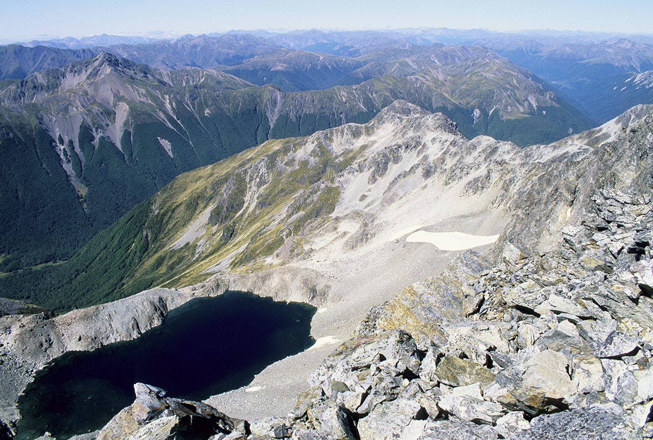
Mt Pfiefer, Arthur’s Pass National Park
Secreted in the foothill summits of western Arthur’s Pass National Park, Mt Pfiefer (1704m) is not so often climbed but is an excellent scramble from its beautifully sited high bivvy, in a basin on the mountain’s northern side.
It’s not only the peak itself that is the objective for trips here but the bivvy and the route in and out which is untracked and unmarked and requires moderate route-finding skills. The summit can be reached in about one hour from the bivvy in good conditions and commands a great view over Arthur’s Pass National Park and the mid reaches of the Taramakau River. It is an easy scramble and the summit is readily traversed to reach the eastern end of bush-clad Lake Kauarapataka.
In essence this two to three day trip is a semi-wilderness experience.