Image of the August 2015 Wilderness Magazine Cover Read more from the
August 2015 Issue
Home / Articles / Wild Trips

The volcano that wasn’t

An aerial view of Pukeiti. Photo: Rob Tucker
Distance
8km
Time
3-4hr
Grade
Easy
Access
Take Carrington Street then Carrington Road from New Plymouth.  Pukeiti Gatehouse is 23km from the city
Map
BH29, or maps of the tracks are available at the gatehouse

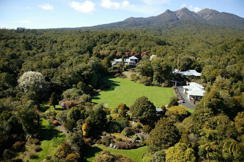
Pukeiti Gardens, Taranaki

Pukeiti has always been a favourite outing for the New Plymouth Tramping Club. Recently we met at the Pukeiti Gatehouse on Carrington Road where I had arranged for the garden manager, Andrew Brooker, to lead us on an informative trail walk.

Brooker explained that in 1951 the Pukeiti Hill block had been bought by enthusiasts who later formed the Pukeiti Rhododendron Trust, as the area, with its acidic soil, 400m altitude, 3500mm annual rainfall and shelter provided by native bush, was ideal for growing the plant.

The garden, covering around 26ha, was successfully established but money was always tight and in 2010 the Taranaki Regional Council assumed ownership and responsibility for the whole 360ha property. Since then, the council has begun major development of Pukeiti, aiming to make it a significant community facility.

The first part of the tramp was through the garden and we soon passed one of the new tree huts, always a popular attraction when families visit. Next we came to a giant rata. Festooned with creepers, this ancient but still healthy tree towered above the forest. We then followed the White Walk to the swingbridge over the Puketewhiti Stream, and entered the rainforest proper. A notice mentions that ‘trampers only’ should pass this point.

At the top of the rise, the Hauler Station sign indicates that the area was logged in the 1920s. Rimu trees were felled and hauled by a winch so they could be loaded on to a bush tramline. The next part of our walk followed this line until we veered to the right on the Pukeiti Summit Track. This is a reasonable climb and we took our time before coming to the Summit Road, which services the telecommunications tower on the hill. From there it was a short walk to the lookout at the top of the 490m hill, where we enjoyed the wide views over north Taranaki towards Kawhia and Raglan.

The name Pukeiti means ‘little hill’ but an earlier Maori name, Piro ngiha, which means ‘burning stink’, gives us a hint of its volcanic origin. Massey University volcanologist, Dr V E Neall, has told us that the hill is a ‘cumulo dome formed by magma pushing up to the surface’. If it had pushed a bit harder we might have had another volcano.

From the summit we followed the road to the Jubilee Track, named for Pukeiti Rhododendron Trust’s 50th jubilee in 2001. This took us down to the tramline again where we took a loop track to the ‘Paint Mines’.

These ochre deposits were mined from 1918, after the First World War, when imported ochre, used to make paint, was not available. At first the material was taken out by horse, but from 1926 the bush tramline was used. Mining ceased in 1931 when the tramline was dismantled. We picked up the Jubilee Track again and the benching and cuttings of the old tramline were quite evident.

Soon we came to the junction of the Jubilee and Kaitake tracks where there is a small shelter and a way-finding notice. The Kaitake Track is more open and as we followed it in a westerly direction we could look up to the top of Pukeiti Hill on our left. It seemed hard to believe that not long before, we were on the top of the hill.

As we headed back to the main part of Pukeiti we passed the end of Te Iringa Track, which would take us to the Hauler Station, but instead we carried on, the Kaitake Track becoming the Patuha Track.

On our right we saw one of the few original rimu left on the property. A splendid tree, it would have been too big for the 1920s axes and saws and so remains today. We then descended to the Puketewhiti Stream, crossing this time by a concrete ford. Soon we found ourselves back in the garden area, taking the Richardson Walk back to the main lawn and the Gatehouse.

– David Harrop