Studying a map of an upcoming trip before leaving home will give you a good idea of the trip’s terrain and difficulty.
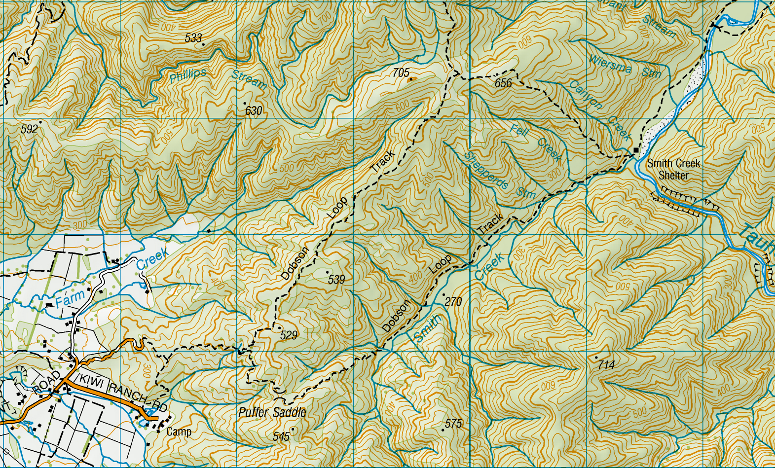
If you were planning a walk to Smith Creek Shelter via the lower Dobson Loop Track from Kiwi Ranch Road, you could glean a lot of information from the map before starting out. This information could help you determine whether you were up to the walk or not. Here are some of the clues we can gather from studying the map pictured.
Contour lines: The brown contour lines on a map give us an idea of how much ascent and descent a tramp will have. Each line represents a difference in height of 20m – the more densely-packed contour lines are, the steeper the terrain. Widely-spaced lines suggest flatter terrain.
Looking at the Dobson Loop Track, it begins near a creek and crosses 11 contour lines to reach Puffer Saddle. We know the track is gaining height because water flows downhill and the creek originates near Puffer Saddle. This means there is a height gain of about 220m from the trailhead to the saddle.
From the saddle, the track crosses eight contour lines to reach Smith Creek, meaning the trail descends 160m. The remainder of the track to the shelter continues on roughly the same contour line, with one final descent as the track crosses two contour lines prior to the hut.
Gridlines: With the distance between each vertical or horizontal gridline being 1km, we can guestimate the distance of a tramp. It looks like the distance to Smith Creek Shelter is approximately 5km.
Creeks: All waterways are potential hazards and we can see from the map that none of the creek crossings in Smith Creek are bridged (though not all bridges are shown on maps). If rain is forecast for your trip, such creeks may become dangerous. Unbridged creeks also suggest there will be some climbing into and out of each creek to get across them. Because contour lines are 20m apart, climbs of up to 19m may not show on the map, so these ups and downs may be considerable over the length of the track. There are eight creek crossings in total, though sometimes there will be creeks that are not shown on the map and some creeks shown on the map may be dry creek beds.
Should you walk?: If you’ve looked at the map before going on this trip, you may decide you’re not keen on the trip because of the climb to Puffer Saddle or you are concerned about the multiple creek crossings. If rain is forecast, you might decide it is safer to use the upper track. But if you do continue, you will be mentally prepared for the challenge. So, enjoy your time outdoors and check your next trip on the map before heading out.
– Heather Grady is an instructor with Outdoor Training New Zealand