If you know your location on the track, you will know how far you have walked and how far it is to your destination.
As you travel, take note of what is happening around you and compare that to the map to help you identify your location. This will help you determine how far you are from your destination.
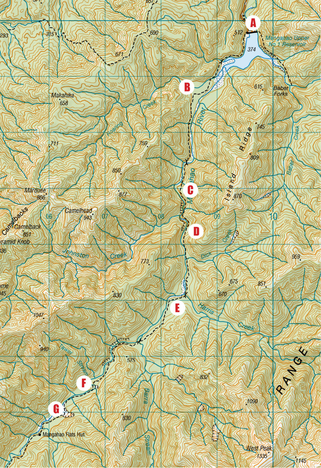
Consider a trip to Mangahao Flats Hut in Tararua Forest Park. The map allows you to imagine what you will see as you travel along the track. While you are walking the track, match the picture of what you see to the features you see on the map.
The trip would go something like this:

1. Arrive at the road end and park under the wall of the dam, Point A. You note a building shown by a square and the track is on the right of the dam.
2. You notice the reservoir on your left and a hill on your right. You cross a bridged creek and then there is another hill on your right. At some point, you notice the water on your left is replaced by a stony dry reservoir bed. You cross another creek then notice you pass through flat land on either side. After turning away from the river the track heads toward hills on the right, Point B.
3. The track skirts the base of the hill toward the river, then crosses another creek. Through the trees, you may notice some pools in the river or the stony river bed. You may hear the river on your left even if you can’t see it. You notice a bend in the river before the bridge comes into view. Once over the bridge, you will see, or hear, the river on your right and the hills will be on your left. You cross a creek and then become aware that you can no longer see or hear the river. You reach a high point at Point C.
4. The track comes close to the river which is in a gorge now. You cross another creek and may notice a short break in the gorge before a second gorge. Shortly, you notice it is flat for a bit on the left with the hills not so close to the track, Point D. You are approximately halfway there.

5. The hills are close on your left and then open up on the side again. Not long after, you cross the much bigger Dick Creek. The hills are close to the track again before opening up again. At this point, you will notice the river bed has wide stony edges again. You cross the bridge over Harris Creek and notice the hills are much further away on your left. Point E is at a bend in the river.
6. As the track approaches the hills on the left, it gets further from the river and you don’t see or hear it on your right. You come back toward the river before you cross the bridged Barra Stream. Shortly after, the hills close
in and the river moves through a gorge. You may see cliffs on the far side through the trees. Then it opens up on the far bank before the river bends away from the track. The track crosses the river and back again to avoid a slip, Point F.
7. Soon after a creek crossing, the track comes onto the river bed at
the base of a big slip, Point G. You are nearly at the hut now.
8. The track returns to the bush and it is open on your left. You notice the river has a stony bed. There is a final creek crossing before the hut. Time to take your boots off and make a brew.
– Heather Grady is an instructor with Outdoor Training New Zealand