Three places to tramp amongst limestone landscapes
Of all the non-biological elements that make up the natural world, rock seems the least dynamic, the least life-like. Water and weather have a dynamism that often lends them living qualities, but – on a human scale at least – rocks seem to be the very embodiment of an unchanging world.
Limestone, however, occupies a curious position in the geological world: it’s made from the shells of marine animals, laid down on ancient sea floors over hundred of thousands or millions of years until compression and compaction change them into rock. Subsequent uplift exposes the limestone.
Its composition lends limestone unusual characteristics: compared with other rocks, it’s highly soluble because its major component, calcium carbonate, is also highly susceptible to chemical weathering. Dissolved carbon dioxide gives water a slightly acidic edge, enough to dissolve limestone. The resulting landscapes are often called ‘karst’, a German word meaning rock or stone.
Caves are the most obvious result, but water can sculpt limestone into other forms – fluting, crevasses, ripples – that seem almost artistic.
Although karst landscapes are not always necessarily comprised of limestone, few other rock types have the requisite characteristics to create karst. And not all limestones form karst landscapes – for example, Oamaru limestone is too porous.
Karst landscapes are still relatively prevalent in New Zealand, but during the Oligocene Epoch, some 34-26 million years ago, limestone occurred to a much greater extent. Since then, erosive processes stripped the land largely bare of this rock type. But where limestone remains, the resulting landscapes are some of our most intriguing.
The Waitomo Caves, the West Coast’s Pancake Rocks and the tors of Castle Hill in Canterbury are among our best-known and accessible limestone landscapes. Others occur in Northland, Auckland, Port Waikato, the Wairarapa, Hawke’s Bay, East Coast, Kaikoura and Te Anau.
Mts Arthur and Owen, Kahurangi National Park, Nelson
In Kahurangi National Park, New Zealand’s largest limestone mountains reach heights of over 1700m. Mt Arthur, a landmark visible from Nelson, is formed from marble – a type of limestone compacted and recrystallised as a result of great pressure and heat. Under Mt Arthur lies New Zealand’s deepest caves, Nettlebed at 889m and one beneath the nearby Ellis Basin, discovered in April 2010, is 1026m. Mt Arthur is easily accessed from Flora car park, near Motueka, with a stay at Mt Arthur Hut en route.
Further south lies Mt Owen, one of the two most glaciated limestone areas (known as glacio-karst) in the southern hemisphere. During past Ice Ages, Mt Owen’s summit supported a small ice cap from which glaciers radiated; sink holes have since formed where – in rocks other than marble – cirques would have resulted. With its confusion of crevices, sink-holes and marble outcrops, Mt Owen offers a surreal tramping experience, especially in mist. Under it lies New Zealand’s longest cave, the Bulmer System, with about 66km of passages. Granity Pass Hut offers a base to explore the area.
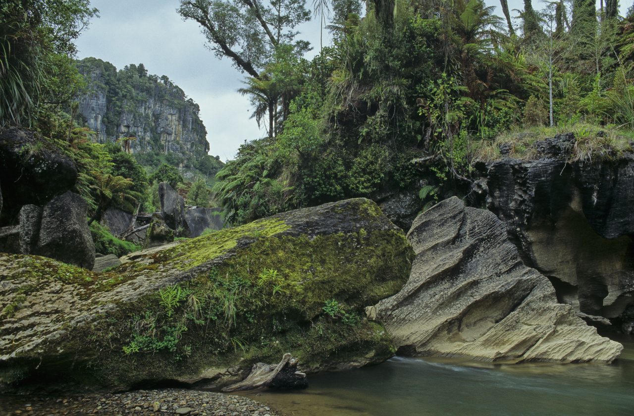
Fox and Pororari Rivers, Paparoa National Park, West Coast
Thousands of tourists visit Punakaiki’s Pancake Rocks knowing nothing of the exquisite gorges just inland. A band of limestone some 10km wide forms the western edge of Paparoa National Park, with some of the finest, least-modified lowland karst landscape in the country. Within are caves, giant sinkholes, layered cliffs and sculptured boulders. The Fox and Pororari Rivers snake between limestone bluffs, linked by the Inland Pack Track which passes a vast limestone overhang, the Ballroom, en route.
Tawarau River, Tawarau Forest, King Country
Less known karst landscapes exist in the King Country’s Tawarau Forest, west of Te Kuiti. With striking bluffs of layered limestone, Tawarau is the North Island’s answer to the Fox River. The 3.5-4 hour Gorge Track, beginning at Mangaohae, follows an old coach trail through the most spectacular part of the Mangaohae Stream gorge.