
1. Brod Bay
From the Control Gates at the outlet of Lake Te Anau, the Kepler Track skirts the shoreline of Dock Bay, passing through beech trees sporting a colourful array of lichens, mosses and other small plants. Easy travel leads to the campsite and shelter at Brod Bay. The serious climbing begins beyond, through the forest and onto the slopes of Mt Luxmore.
2. Luxmore Hut, Luxmore caves and Mt Luxmore
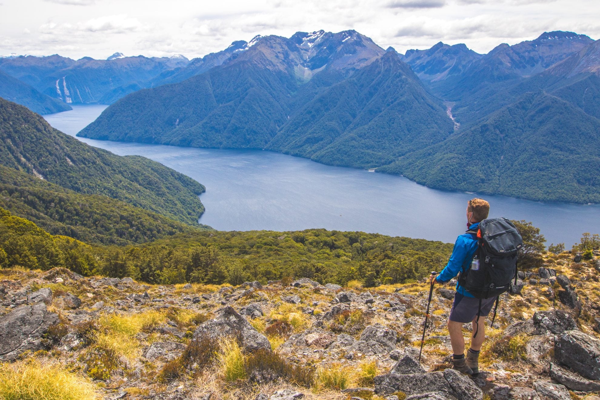
Zigzags help ease the gradient, but it’s still a steady climb, passing limestone bluffs at one point before finally emerging onto the tawny tussock tops. Luxmore Hut is just 30 minutes away, perched on poles with a commanding view over the South Fiord, and the Murchison Mountains. If the weather remains good, it’s probably worth scrambling up Mt Luxmore (1472m), or visiting the nearby caves (take a torch).
3. Forest Burn Shelter
The track sidles neatly around the side of Mt Luxmore, with a short side-trip to the summit, so you get a second crack at the highest point on the route. Beyond, the ridge narrows, with views of Forward Peak, before reaching Forest Burn Shelter, one of two shelters on this tops section.
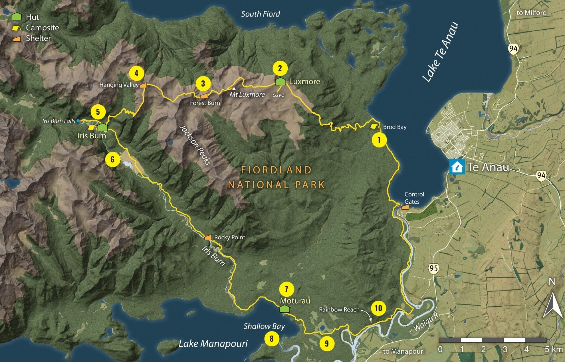
4. Hanging Valley Shelter
The sense of going deeper into the mountains strengthens as you head west, with the sinuous South Fiord probing into the heart of Fiordland’s central mountains. The track alternates between sidling around knolls, and following the ridge directly, and Hanging Valley Shelter makes a convenient place for a break before the descent into the Iris Burn.
5. Iris Burn Hut and waterfall
The steepest descent of the track leads down into the Iris Burn, which drains the heart of the Kepler Mountains. ‘Burn’ is the Scottish word for stream, commonly used in Southland and Otago, which was settled by Scots. It seems to suit the landscape here. Iris Burn Hut occupies a clearing in the beech forest, with a view of Mt Tinsley, named after New Zealand scientist Beatrice Tinsley. From the hut, a worthwhile 20-minute walk leads to the Iris Burn Falls.
6. Big Slip
From the hut, the track follows the true left of the Iris Burn down a glacier-carved valley. At one point, there’s a view of a landslide that occurred in 1986, leaving a huge scar known as the Big Slip. The track follows the burn all the way to the shores of Lake Manapouri, which it skirts to reach Moturau Hut.
7. Moturau Hut
Moturau Hut has a pleasant outlook over the myriad islands of Lake Manapouri, some shaped like beehives. On a calm day, it’s a place of tranquillity and birdsong.
8. Shallow Bay
An enjoyable side-trip from the main track leads to the six-bunk Shallow Bay Hut, one of the park’s older and smaller huts, near the mouth of the Waiau River. This river links Lake Te Anau with Lake Manapouri, and the remainder of the Kepler Track more or less follows its upstream course back to the Control Gates.
9. Wetland
The track passes a sizeable wetland, where a boardwalk and viewing platform offer views of the Jackson Peaks and the extensive stands of forest on the surrounding flats. After crossing the Forest Burn, the track reaches a large footbridge spanning the Waiau. This offers the option of finishing the track at Rainbow Reach.
10. Rainbow Reach
Trampers wanting to complete the whole Kepler circuit continue on for another 2-3 hours on a well-benched, easy section of track that follows the true right of the river.
When to walk
Driest period: July-September (less than 82mm of rain)
Wettest period: January and October (more than 133mm of rain)
Warmest month: January (9.5-20°C)
Coldest month: July (1.1-8.4°C)
Quietest period: November and April have less than half the number of trampers as December to March, when the walk is at capacity.
Best time: April
April is the quietest month of the season – just 544 walkers were on the track compared with 1325 in March, when the
track is fully-booked. April is also one of the driest months and has an average high of 15°C in Te Anau. Expect some frosty starts and perhaps the odd snow flurry on the alpine sections.
Temperature and rainfall figures are monthly averages from the Te Anau weather station. Temperatures on the alpine section are likely to be colder. Tramper numbers from DOCdata from the 2016/17 season.


