
Every year at least a couple of hundred trampers get into strife while exploring the great outdoors. Most pull through with nothing more than an interesting tale to tell, but some well and truly come a cropper.
Wouldn’t it be nice to know the spots where people most often get into trouble? Wilderness rang search and rescue volunteers and local tramping club members in high incident areas to get the low down on what goes wrong and where.
What follows aren’t necessarily the most dangerous places in the country, but they are the places locals say often prove dangerous, even for the best of us.
Many uber-experienced trampers will snigger disdainfully at the suggestion tracks in Tongariro National Park are even remotely dangerous.
‘Highways’ like the Tongariro Alpine Crossing (TAC) and the Northern Circuit are so well graded and marked it seems impossible anything could go wrong. But the fact is, many people – usually tourists – do get into trouble on these seemingly pedestrian tracks.
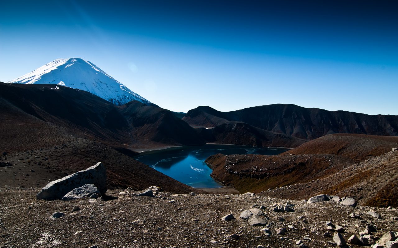
Local SAR volunteer Terry Blumhardt runs Walking Places, a guided tramping business, in the area. He says there are a number of danger points on the TAC, such as the track between Lower and Upper Tama lakes and track between South Crater and Summit Ridge.
Taupo Tramping Club President Colin Mcleod says his club has never had any problems on the TAC, but members have often turned back because weather conditions made it too dangerous to continue. And when it comes to effort and risk, McLeod reckons Mt Ngauruhoe is a nine out of 10. “It’s not so bad going up, but coming down you have to be very careful because if you miss your footing you won’t stop falling until you hit the bottom,” he says.
Blumhardt agrees descending the mountain can be dangerous. “People have become lost because in bad visibility they couldn’t see where South Crater was,” he says. “Because Ngauruhoe is largely featureless, you can be easily affected by things like the wind direction. You think you’re descending straight down but the wind can make people corkscrew down the mountain.”
To the east of Tongariro and across the Desert Rd lie the Kaimanawa Mountains. Mcleod says this area of the Central Plateau is another zone that can catch out even experienced trampers.
Specifically, Umukarikari, Urchin and Ngapuketarua tracks can be problematic. Below the bush line, fallen trees, overgrown track sections and missing track poles can lead trampers astray and above the bush, steep bluffs, slippery rocks and fast changing weather can conspire against them.
Bad trips
In April this year a man was helicoptered from the slopes of Mt Ngauruhoe after a falling boulder fractured his leg. In January a teenager fell 50m down the mountain and was hit by falling rocks that followed him. He was flown to hospital coughing up blood. In May, a couple was rescued from the Red Crater on Mt Tongariro after losing their way in low visibility. In the same month, a woman got lost on the TAC and was lucky to be found alive at 1am in zero degrees on Tongariro.
Survival Tips
Mt Taranaki has a reputation for being a killer. Rumour has it that it’s responsible for the highest number of annual fatalities of any mountain in New Zealand.
Because of heavy rainfall, the mountain, and its tracks, get seriously eroded. Local LandSAR chairman Mike Johns says erosion is worst on the western side of the mountain from Holly Hut around to Lake Dive and particularly along Stony River Track.
Johns explains erosion is “cutting out” gullies down many of the streams which means track markers have had to be moved over and over again. “Some of these streams that tracks go across are now 50m wide whereas a couple of years ago they were little streams five metres wide,” he says.
Johns says many trampers have difficulty finding markers after crossing a stream bed and make rushed decisions to head in the wrong direction.
“I hear it through DOC circles that people have been getting lost in those areas but managing to find their own way out,” he says.
Another danger zone on Mt Taranaki is the summit track where a number of people have died or been injured over the years.
Taranaki Alpine Club member Bryan Krijger says people often get into difficulty coming down from the summit rather than at the top.
He says one trouble spot is the end of the Lizard at about 2120m where the track veers right onto the North Ridge. “They keep going straight down past the point they should turn right,” says Krijger. “There’s nothing to say you’ve hit the bottom of the ridge and you can keep going for a while before realising.”
Bad trips
Krijger says a man died this way on the mountain a few years ago. He can’t remember the man’s name, but says he missed the turn at the bottom of the Lizard and walked down too far. He waited for help, but was dead from exposure by the time searchers found him. In October 2008, after heavy rainfall conservationist Diane Campbell-Hunt drowned when she tried to cross the Kaupokonui Stream on the south side of the mountain.
Survival tips

Tararua Forest Park is the largest DOC park in the North Island and is renowned for its ruggedness as well as the wind and rain thrown on it.
In May this year, Palmerston North search and rescue leader Sergeant Andy Brooke became lost in the park and told the New Zealand Herald he would have died if it wasn’t for his personal locator beacon.
The fact Brooke had experience and all the gear – maps, compass, GPS – and still got lost, demonstrates how careful trampers need to be in the park.
Wellington Tramping and Mountaineering Club President Megan Banks says because the park is close to major urban areas and is easily accessible, attracting a large number of people with limited experience who underestimate the terrain and weather conditions.
“The Tararuas are particularly prone to variable weather conditions,” Banks says. “High winds and mist on the tops are common. This, combined with a wide diversity of tracks and rivers, means basic skills and ‘real life’ experience is almost a necessity.
“Club members have met people at Powell Hut in inappropriate gear [like jeans and T-shirts] and with no map, attempting to carry on to Mt Holdsworth (1470m) in high winds and low visibility.”
Banks says there are lots of lookalike ridges in the Tararuas that lead trampers astray. “If you are not getting the map out regularly to check which knob you are on, it is easy to under or over estimate where the turn off is,” she says.
Knife-edge ridges, such as the Broken Axe Pinnacles, and river crossings also need careful decision making. Wires running across rivers indicate a safe place to cross, but Banks says sometimes this is not always the case.
“For example, near Smith Creek Shelter, where there is potential to be swept straight into the Tauherinikau, it’s actually better to bush bash 20 minutes upstream to a less hazardous spot,” says Banks.
Murray Johnston of Wairarapa Search and Rescue says Totara Flats is another area where people come to grief.
“The main problem in the area is none of the side creeks are bridged and at least a couple of times a year people get stuck at Totara Flats Hut or in-between various creeks,” he says.
Bad trips
In 2009, the bodies of Te Papa boss and experienced tramper Seddon Bennington and his friend Marcella Jackson were found just a kilometre from Kime Hut, which would have given them shelter from a storm. Walking at 1400m in 80km/h southerly winds and snow, the pair lost the track and eventually died of hypothermia.
“If people have been to Field or Kime hut in good conditions they may get complacent, but the weather can change very quickly and it can be very exposed up there,” says Megan Banks.
Survival tips
The Nelson-Tasman region has no shortage of wilderness for trampers to go wrong in. “There’s probably no place I can think of that someone hasn’t come to grief in one way or another,” says Sergeant Mike Fitzsimmons, of Nelson Search and Rescue.
In June, Fitzsimmons coordinated the rescue of a man from the Inland Track in Abel-Tasman National Park after he set off his locator beacon. Motueka Search and Rescue President Gerry Tonkin was also involved and has other grim tales to tell about the country’s smallest national park.
“People think the Abel Tasman is a softy, but the Inland Track can be very rugged,” he says. “The Coastal Track is wheel chair standard; you could do it in your Crocs if you want. On the Inland Track you’ve got to have all the gear.”
Tonkin says trampers get into difficulty around Awapoto Hut and Moa Park Hut.
“It looks like you could walk down to the coast in a couple of hours [from Awapoto Hut], but we’ve had people take three days,” he says.
Another danger zone in the Nelson-Tasman region is Mt Arthur in Kahurangi National Park. Tonkin says easy access from Flora Saddle car park means people take it too casually and get caught out when the weather turns bad.
“They get out of their car in their jandals and their stubbies and start walking up to the bushline (1300m) and all of a sudden the weather changes,” he says. “It’s very deceptive.”
DOC Nelson Lakes programme manager John Wotherspoon says the Angelas Hut section on the Travers-Sabine Circuit is another high risk tramp in the region that many people underestimate. He says people who’ve done the Great Walks think the track will be the same quality. “But it’s far more of a tramping track particularly on Robert Ridge through to Angelas [where] you’re exposed for a long time,” says Wotherspoon,
Avalanche risk also adds to the dangers on the Travers-Sabine Circuit. DOC closed Hopeless Hut, on the south side of Angelas Ridge, because it sat on an avalanche path. “You can get any number of avalanche paths over the Travers-Sabine Circuit that can be active up to mid November, particularly after a snowy winter,” says Wotherspoon. “No one has been hit yet and we do put up signs that warn people [where] not to stop.”
Bad trips
Tonkin says in the early 1990s a tramper tried to follow the Awapoto River to the coast and drowned. “We eventually found about six inches of his pack frame and about three inches of one of his thigh bones,” says Tonkin.
Karl Ezra Sorenson went missing in the Mt Arthur area in 2001 and wasn’t found until three years later. Search and rescuers found a note he’d left saying he’d gone north when tragically he’d actually walked south.
Earlier this year English tourist James Esbester descended the wrong side of Mt Luna and was lost for six days without food, shelter, warmth or even his glasses or replacement contact lenses.
Survival Tips

Other than mischievous kea prying the rubber off your car, there are a number of more serious and deceptive threats in Arthur’s Pass National Park.
In fact, deception is the name of the game when it comes to the Mingha-Deception Route, which runs from the confluence of the Bealey, Mingha and Edwards rivers adjacent to SH73 along the Mingha River through to Deception River until it reaches SH73 again just past Otira.
DOC Arthur’s Pass visitor service ranger and local search and rescue chairman Graeme Kate says the route is in Lonely Planet as a ‘must hike’, but the book fails to warn people about the many dangerous river crossings.
“There’s no track down the river so you’re basically crisscrossing all the time,” says Kate. “The Deception has 31 compulsory river crossings that are quite bouldery and swift.
“It’s a beautiful tramp and has some nice side trips off it, but it lives up to its name.”
Over the years Kate has seen some sad river drownings on the route because people were too eager to cross swollen rivers to reach their car or to make a travel commitment.
There have been 26 river drowning fatalities in the park since 1926, but the number one cause of death is falls with 48 fatalities. In June this year, Kate says three experienced climbers suffered injuries from falling accidents.
Kate says Avalanche Peak is another deceptive area of the park because it’s easily accessible from the road but just as exposed to the weather as other mountains in the park.
“It’s one of the best day walks you can do in New Zealand, but people don’t understand they’re on a real mountain,” says Kate. “Because we had multiple fatalities up there in the early days the coroner got us to put in a picket fence of track markers, but amazingly people still get lost.”
Of the two tracks that go up Avalanche Peak, Kate says Avalanche Peak Track is more problematic than Scott Track.
“On the Avalanche Peak Track people tend to be committed because it doesn’t have good views until the summit, so they feel they must keep going.
“When there’s ice and snow up there we normally point people to Scotts Track because it gives them the best views and they can choose when they turn around.”
Bad trips
Two Kiwi trampers nearly drowned in the Mingha River in October last year when they tried to cross it in very high flow. Upon entering, both women were swept off their feet with one managing to get out on one side and the other swept 1km downstream until she was able to scramble out on the opposite side. They found each other, but couldn’t hear one another above the roaring river.
Fortunately one of them returned to Goat Pass Hut where she radioed for help.
Survival Tips
Sometimes places that seem the least dangerous are the most dangerous and so it is with Queenstown’s Ben Lomond-Moonlight Track loop.
“A lot of people seem to go haywire on that one,” says Senior Sergeant John Fookes, leader of Whakitipu police search and rescue. “In the tussock land above the bush line the track is marked but you’ve got to keep your wits about you to stay on it. Every year we have a few go missing there up there.”
Starting with a quick ride on the Skyline Gondola up to the chalet, the track quickly rises to 800m before zigzagging to the summit of Ben Lomond (1748m). “People think because they can still see
Queenstown from up there that it’s still part of civilisation,” says Fookes. “But you go from being in a relatively balmy environment in Queenstown to the exposed tops and they’ve got themselves into a potentially hostile environment.”
Fookes says around 2000 people do the five hour trip every year and some make the “weirdest possible mistakes in areas you wouldn’t think possible”. Many people don’t give themselves enough time to complete the loop before night falls. Without a torch or a decent map, they find themselves in the dark following false tracks going in the wrong direction. Last month, Fookes says someone got lost and was eventually found at Moke Lake, in the complete opposite direction to the loop track.
“When you’ve got ease of access people sometimes drop their guard a bit,” says Fookes.
Cautionary tale:
In September last year, Christchurch Tramping Club member Silvia Horniakova got completely lost just after the Ben Lomond Saddle (1316m). It began to snow, and in fading light she lost sight of the orange route markers. She got cold and wet crossing the wrong river and realised she needed to find shelter. Fortunately she found a wood shed in which she was able to start a fire.
Whakitipu search and rescue volunteer Ed Halson said the weather was so bad Horniakova was lucky to be found alive.
Survival tips:


