


New Zealand’s 10 Great Walks are superb tramping trails for good reason: they pass through some of the country’s finest landscapes. Roving editor Shaun Barnett selects his favourite views.
Most Great Walks offer an appealing diversity of scenery; forests, mountains, river valleys, beaches. Picking a highlight from each is subjective, but having walked (or paddled) them all, these are the sights that have stuck in my memory.
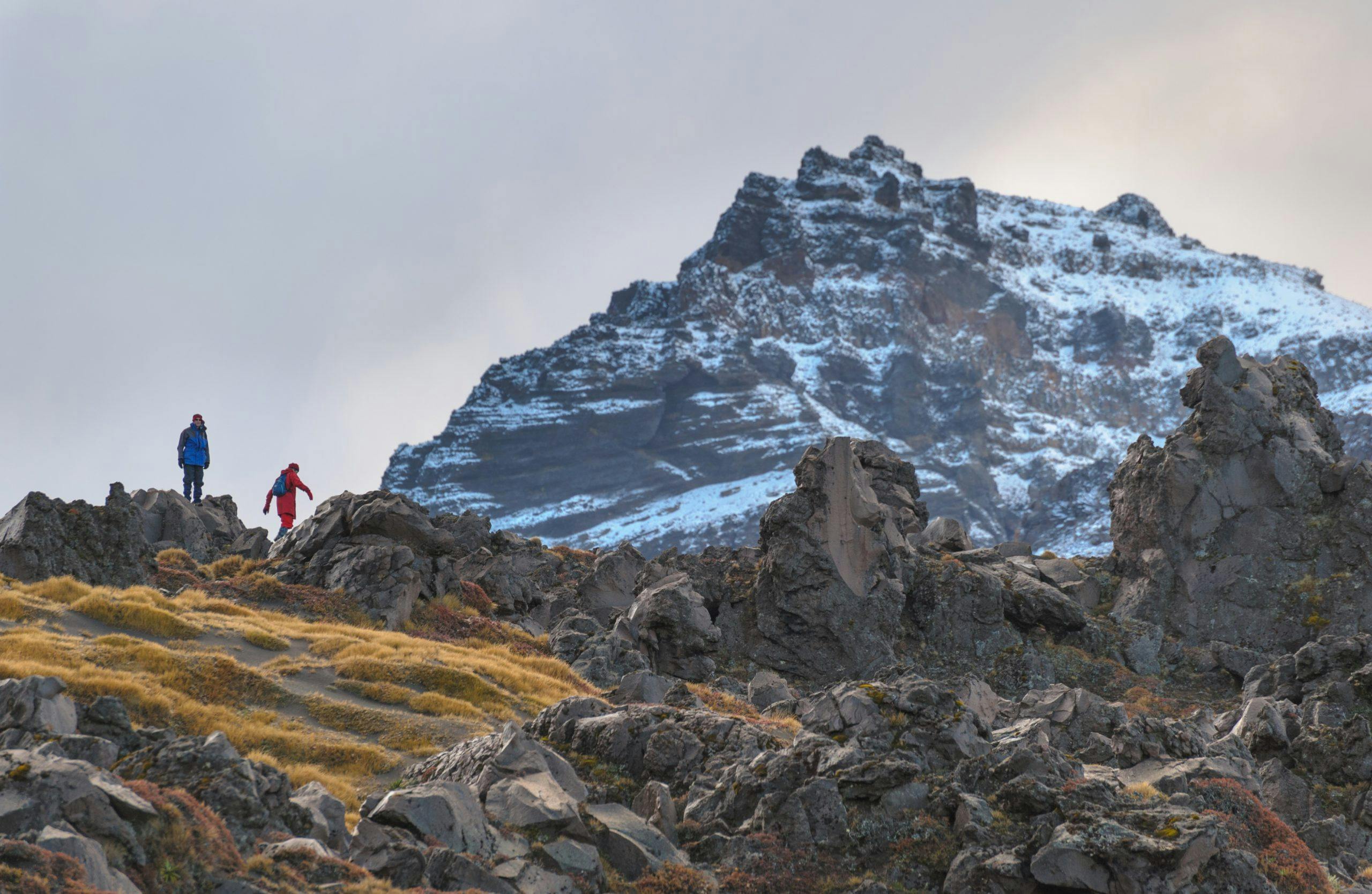
Tongariro Northern Circuit
Volcanoes, desert-like landscapes, old explosion craters, dazzlingly colourful lakes; there’s a great deal to appreciate about the Tongariro Northern Circuit. However, one of my favourite sections is the more understated Ōturere Valley. With its numerous lava formations of all curious shapes and sizes, it has an eerie quality in misty weather, and even under the cover of snow, these formations seem like otherworldly sentinels.
Lake Waikaremoana
If you’re tramping the Lake Waikaremoana Circuit anti-clockwise, beginning from Ōnepoto, there’s a steady climb through beech forest, which becomes progressively more stunted the higher you go. At first, there are no views, but higher up the track brushes the edge of Panekiri Bluffs, and there are several viewpoints. The land drops precipitously to the sea of rippled waters, and beyond are the crumpled, bush-covered ridges of the vast Te Urewera.
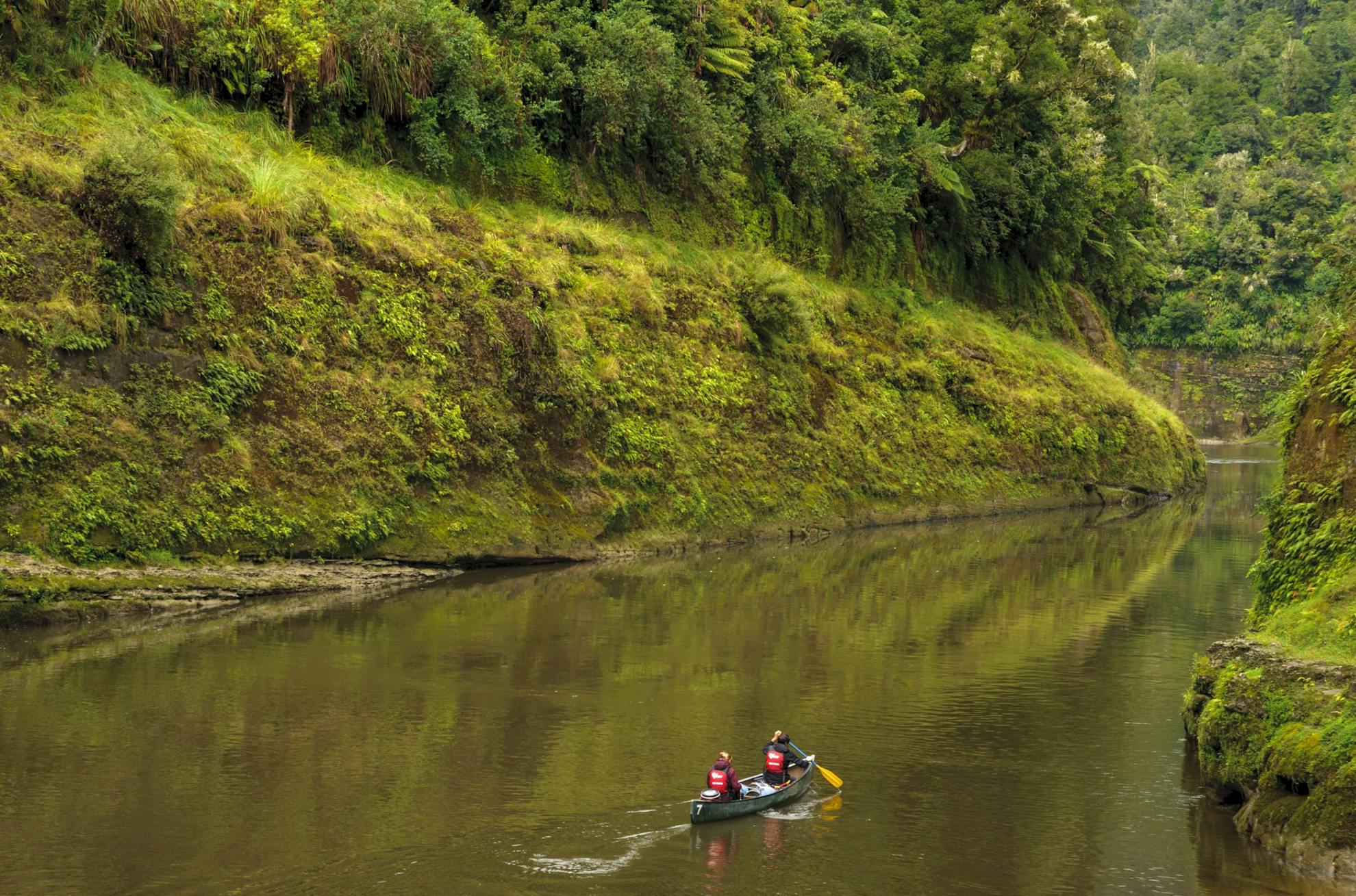
Whanganui River Journey
No other New Zealand river offers such a navigable length as the Whanganui, and it has been used for centuries as a passage from the coast through to the interior of the North Island. In a kayak or canoe, it’s easy to feel insignificant in this sinuous green canyon and yet the journey is within the ability of anyone with moderate paddling experience. Arguably the finest part of the Whanganui Journey is located just downstream of Mangawhiti Campsite where paddlers float through a high-sided canyon, festooned with verdant vegetation and sometimes offering superb reflections.
Abel Tasman Coast Track
Granite dominates the coastline of Abel Tasman National Park; it forms the headlands over which the Abel Tasman Coast Track climbs, it is the origin of the area’s famously coarse, golden sands, and in places the sea has whittled marvellous sculptures from it. Perhaps none better than those of Anapai Bay, an hour north of Tōtaranui.
Heaphy Track
Picking just one highlight from the diverse Heaphy Track was too hard, so I’ve chosen two. Firstly, where the Heaphy River disgorges into the ocean, watch the rolling waves from the Tasman Sea crash into the limestone of Heaphy Bluff. Then from Perry Saddle Hut, at the track’s eastern end, scramble up the route to Mt Perry for extensive views over the Gouland and Mackay downs as far as the sea. The serrated skyline of the Dragons Teeth is in the other direction.
Paparoa Track
Before the development of the Paparoa Track, few trampers had seen the arresting sight of what is now called The Escarpment. First viewed from above Moonlight Hut, this block of exposed rock seams is tilted at an imposing angle, leaving eroding and formidable bluffs on the western side. The first thought is: where does the track go? However, the eastern side of the Escarpment is gently angled and the trail contours around the slopes, with occasional giddy viewpoints over the western bluffs.
Routeburn Track
The beauty of the Routeburn’s landscapes are internationally renowned: the turquoise waters of the Route Burn itself, the extensive flats which rise to sheer peaks, the glacier-carved Lake Harris, and the exquisite Lake Mackenzie with the anvil-like Emily Peak at its head. But for a sheer powerful vista, it’s hard to beat the dramatic view over the Darran Mountains from the Hollyford Faces. Mount Tutoko and Mt Madeline – Fiordland’s highest peaks – are visible as well as the great sweep of the Hollyford Valley.

Milford Track
I’m going out on a limb and not picking Mackinnon Pass, but instead opting for Sutherland Falls. Plunging 580m in three great leaps from Lake Quill, these falls have long been famed for being New Zealand’s highest (although that claim has been blunted by recent discoveries of higher falls in other parts of Fiordland). The base of the falls is reached on a side-trip from the main track in the Arthur Valley. I first witnessed them after heavy rain. So much water sprayed off in great sheets that the falls seemed almost like their own weather system.
Kepler Track
Lake Manapōuri has been called New Zealand’s most beautiful lake, and then there are the majestic beech forests of the Waiau Valley, or the Iris Burn falls. But on a fine day, the Kepler’s best view is over Lake Te Anau’s South Fiord from the Luxmore tops, with the vastness of Fiordland’s mountains stretching beyond the curvature of the Earth. In fact, the whole day’s tramp along the tops between Luxmore and Iris Burn huts is pretty much one extended highlight.
Rakiura Track
There’s the twisted, flaking bark of the mānuka forests, the quiet lapping sea at Port William, the foam-flecked waters around the intricate shoreline of Paterson Inlet/Whaka ā te Wera, and the chance to hear or even see a Rakiura tokoeka/kiwi. All are worthy highlights of this most southerly Great Walk. Instead, I’ve picked a place that reflects the area’s surprising amount of past human endeavour. Several successions of small Māori communities lived at Māori Bay before saw-millers established a home there early in the 20th century. The rimu didn’t last, and by 1931 the area was abandoned; leaving relics such as a rusting boiler. It’s comforting to know that, despite sustained human activity, nature has reigned in the end.
