
As a Māori, there are several ways I go about anchoring myself with and within the natural world, no matter the tramp: walking with whakapapa, connecting with my Māori cosmos, and making the mythology matter.
In my case, walking with whakapapa on the Rakiura Track involved researching the name ‘Rakiura’ to know more about its Māori meaning and origins. Rakiura’s original Māori name was ‘Te Puka o Te Waka a Māui’ – the anchor stone of Māui’s canoe. While Māui worked with all his might over days and nights to reel-in his wild and thrashing fish ‘Te Ika’ (the North Island), Te Puka kept everything stable.
A chain-link at Lee Bay memorializes Māui’s battle, physically joining Rakiura and Motu-pōhue (Bluff). Passing beneath this symbol of Rakiura’s whakapapa gave me goosebumps, Māui’s magical story suddenly present and accessible.
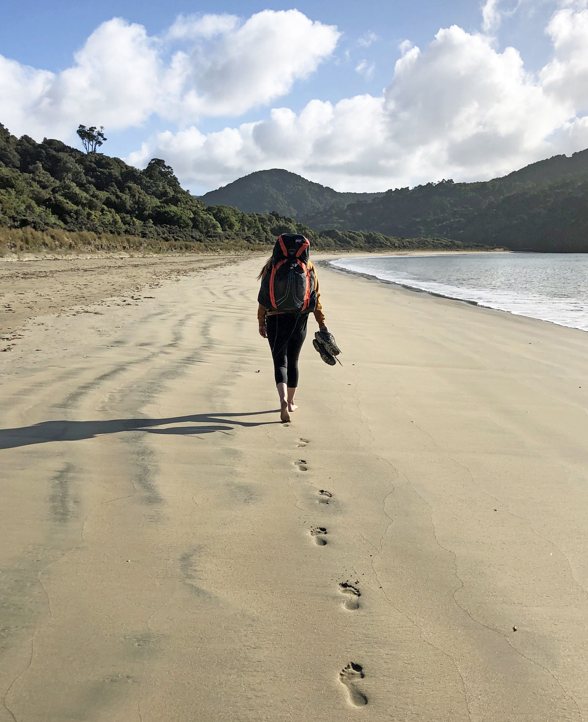
Connecting with my Māori cosmos on the Rakiura Track was easy. In Māori mythology, Ranginui is Sky Father and Papatūānuku (Papa) Earth Mother. On the Rakiura Track, Papa was the earth and its different qualities beneath my feet: the wind-blown sand brushing my face as I walked along Māori Beach with oystercatchers; the grandparent granite boulders – kaumātua (elders) – I saw peeking out of fern and frond between North Arm and Oban; and oh was she mud, calf-deep in parts and an honest test of my Cactus Instigaiters and their resilience (bomb-proof, basically).
Clinging to my creation story in this way anchors me in time and space within my entire Māori whakapapa and strengthens its connections. On Rakiura, Papa took this a step further, similarly clinging to me (and my gear) as if to say: ‘Nau mai – welcome. Prepare to really know me.’
Making the mythology matter means reading into the local narratives of the area, like the remarkable success of kiwi on the Island. Rakiura’s tokoeka kiwi number about 20,000 – spectacular compared to its permanent human population (around 408).
Māori legend initially places kiwi in the sky alongside the God of Sky-dwelling Birds Tāne-hokahoka, among trees that were dying out due to too many soil-based bugs and no ground based birds to counterbalance. In response, kiwi heroically gave up a beautiful technicoloured plumage, dedicating themselves and their descendants to a future on the ground with Tāne-hokahoka’s brother, Tāne-mahuta. Kiwi grew thick strong legs for walking through bush debris; a nose more suited to foraging on the forest floor; and an unremarkable brown feather cloak, coloured for camouflaging with Papa.
On the Rakiura Track, I found tokoeka to be extremely loud and elusive. Dramatic screeches echoed across Potirepo-Port William and North Arm campsites, both nights. And armed with my kiwi-spotting kit, red cellophane covering the white beam of my headlamp, I searched enthusiastically for them but without luck. But tokoeka’s physical absence wasn’t the be-all and end-all. Though it wasn’t the encounter I’d hoped for, my awareness of everything that kiwi had sacrificed to become tokoeka kept me invested – anchored – in the possibility, the maybe.
It still does. Firmly tethered to the Rakiura Track through Māori whakapapa, cosmos, and myth, I feel destined to go back.
– Tānia is a teacher with a background in kaupapa Māori early childhood education, specialising in nature-based exploration.
Meet the warden: Wayne King
Wayne King was warden at North Arm Hut in the 2019/20 season.
Best wildlife encounter: Finally being able to identify the local southern tokoeka (kiwi) pairs around the hut and knowing which pair was which by the time of night that they call.
What’s something you recommend walkers do? To keep an eye out for southern tokoeka and to use the red light on their torches to spot them. I could point walkers to the areas where they are most likely to see the birds. It’s nice just to sit outside the hut where you can be visited by ruru/morepork and stare at the amazing night sky.
What’s in tramper’s packs: It’s not so much what’s in their pack as what’s not on their feet. I’m always surprised when I see people tramping barefoot. These people tend to also carry a day pack with lots of shopping bags tied to the outside. I’ve also noticed people packing self-heating food systems, which seem to do a good job and negate the need to carry a cooker or a pot.
Best time to walk Rakiura: Expect mud at any time, though it’s probably driest in January.
In the neighbourhood
Alternative track: Fly to Mason Bay, and walk back to Oban via Freshwater and North Arm huts.
Since you’re already here: Check out the wildlife sanctuary of Ulva Island.
Just got a weekend? Forget the huts, and spend a night camping at Māori Beach, located on the Rakiura Track.
Where to stay: There is a range of accommodation options in Oban.
Where to stock up: Outdoor Adventure Shop and supermarkets in Oban.
Walking Rakiura Track
Two gorgeous coastal sections form the highlight of the southernmost Great Walk.
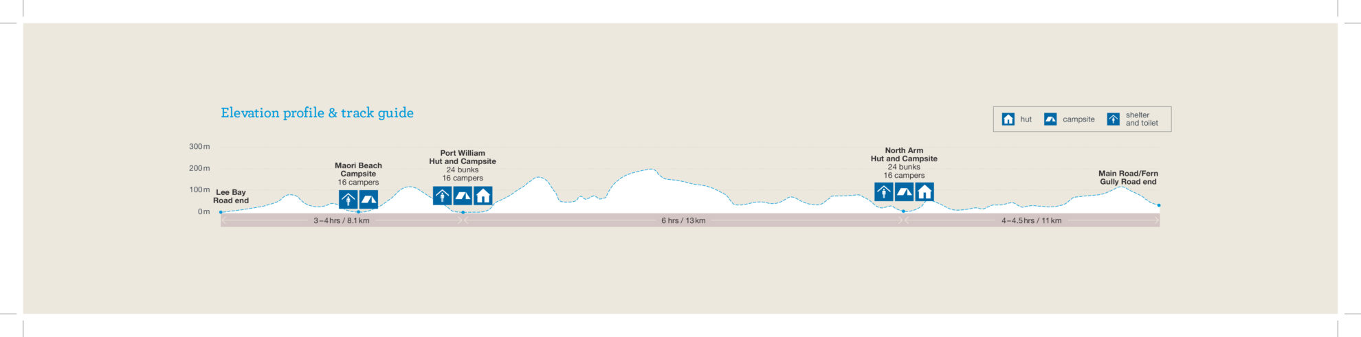
Lee Bay to Port William Hut
8km, 3-4hr
Starting from the large chain sculpture symbolising the anchor stone of Maui’s canoe, the track sidles above the bay to Peters Point and around to Wooding Bay and Māori Beach. At the northern end of the beach, a bridge spans a tidal estuary and then the track climbs to a junction. Head right and descend to Port William, where the 24-bunk hut is set in a sheltered bay surrounded by large gum trees which date to a short-lived settlement populated by Shetland Islanders in the 1870s.
Port William Hut to North Arm Hut
13km, 6hr
Retrace your steps to the track junction to begin the forest section of the walk, which follows the route of a tramline. The bush is not particularly spectacular because much of it was milled in the early 1900s and with a lack of views, the main points of interest are the milling relics found alongside the track. North Arm Hut (24-bunks) is worth the forest toil, though – its deck and windows provide unrestricted views of the bay. Keep an ear out for kiwi calling at night.
North Arm Hut to Fern Gully Car Park
11km, 4.5hr
The track sidles around the headland from North Arm to Sawdust Bay, passing a sawmill site which was operated between 1914 and 1918. The mill was an ecological disaster – so much sawdust entered the bay it killed all marine life. The track continues inland through a forest dominated by rimu and kamahi and emerges at Kidney Fern Arm where there is a historic dam. At Kapipi Bay, where there were once two sawmills, the track follows the former Kaipipi Road – at one time the busiest road on the island – to the walk’s end. It’s a 2km hike along Main Road back to Oban, but there is an alternative route back to town along the coastal Ryans Creek Track.
34 years of inspiring New Zealanders to explore the outdoors. Don’t miss out — subscribe today.

Questions? Contact us


