Handrails
A handrail is an identifiable linear feature that helps guide where you intend to go.
For example, if a track is meant to stay on one side of a river, the river becomes a handrail. You may lose the track, but you are not lost as you have your handrail to guide you.
Here are two examples where you might use a handrail:

1. On track
The track from Mitre Flats Hut shows the track on the true right (the right side when looking downstream) of the Waingawa River. The river makes a useful handrail if you find yourself off the track. Keep the river on the true right and you’ll be heading in the general direction you wish to go.
You may find yourself on something that looks like the track, possibly made by animals or people. If this ‘track’ crosses over the river, it’s a big clue that you’re not on the correct track.

2. Off track
A handrail is particularly useful when travelling off track. In this example on a proposed off-track route from Jumbo Hut to Atiwhakatu Stream, you can use two creeks as handrails and to form a containing boundary. You may not be sure precisely where you are between the two creeks, but as long as you remain between them, you are not lost.
Catching features
A catching feature is an identifiable feature that you expect to find if you overshoot another feature you are looking for. For example, a bend in the track may be just past a track junction. If you come to the bend in the track, you know you have missed the track junction. This is a particularly useful tool for ensuring that you don’t overshoot junctions or huts.
Here are two examples where you might use a catching feature:

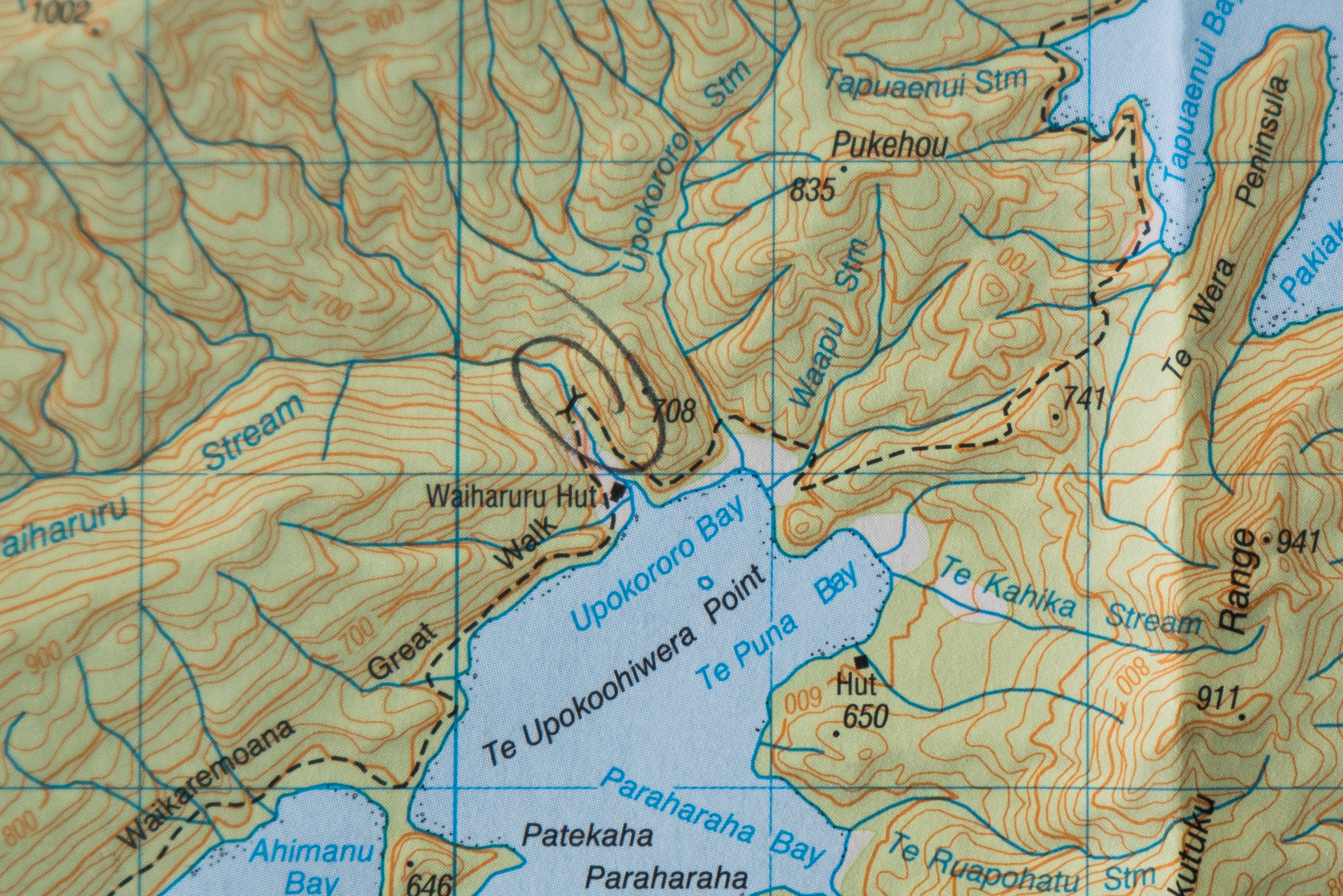
1. To catch a hut
Waiharuru Hut sits on the shore of Lake Waikaremoana. But if you miss the turn-off you can overshoot it. The bridge just past the hut forms a catching feature if you inadvertently pass the hut, If you reach the bridge, you’ve gone too far and need to turn back.

2. To catch a turn-off
When travelling in the bush, changes in contour are often the most obvious identifiable features. Is the track going up or down? Is it steep or a gentle grade? Good navigation involves using these features along with time travelled to help identify where you are on the map. A change in contour may be used as a catching feature.
In this example, a tramper is walking Gentle Annie Track to Mountain House Shelter. At a junction, the Totara Creek Track branches south and descends while the Gentle Annie Track continues to climb for 100m before a short descent and then levels off. If you start to go down steeply, you know you have made a wrong turn at the track junction and should turn around.
– Heather Grady is an instructor with Outdoor Training New Zealand