
January: River tubing, Tararua Forest Park
Imagine a fine, warm day, the sun glinting off the rapids, the walls of a bush-clad gorge rising above, and your feet pointed downstream, hanging over the edge of a tractor inner tube. The current calls the tune, pulling you down the valley, and the scenery flows by like a slow-motion sequence in a documentary. Emerald green pools beckon, and when you’ve had enough of the water, the sun-warmed rocks offer a place to pull up and devour a well-earned lunch. This is Tararua river tubing.
There’s a long tradition of river trips in the Tararua Range, for good reason. A curious, and unique feature of the range is that all of its major rivers are gorged, yet are still navigable by suitably waterproof trampers. Naturally, summer is the only time to traverse gorges. In January and February, water temperatures peak, although a long, dry summer might mean tubing trips are still possible in March and early April. You’ll need a good three-quarter length wetsuit, a truck or tractor inner tube, pump, repair kit, helmet and all your gear stowed in watertight bags within your pack. Avoid heavy leather boots, but make sure your footwear is suitable for walking, as most gorges require at least some foot-slogging.
Beginners might like to test themselves first with a day-trip down the lower Waiohine River between Totara Flats and the Waiohine Gorge Road. Another relatively simple trip is the lower Tauherenikau, ending near Featherston. The lower Ruamahanga makes an easy tubing trip too, with pleasant pools and several not-so-serious rapids. Longer and more serious is the Otaki River downstream of Waitewaewae Hut, or the Hutt River Gorge beginning at Pakuratahi Forks. And for the adventurous and experienced river rat, the ultimate Tararua river trip is the full length of the Waiohine River – the most heavily gorged watercourse in the park. The highlight? Probably a section upstream of Mid Waiohine Hut where the gorge narrows so much that the trees on either bank have their branches intermingling.
While river tubing should not be underestimated, given the right weather, companions, experience and equipment, it offers an exhilarating variation on the tramping experience.
It goes without saying that you should only tackle rivers on a good forecast, and when water levels are normal, with clear visibility. Solo tubing is to be avoided at all costs; a group offers not only safety but companionship.
Tararua tubing trips
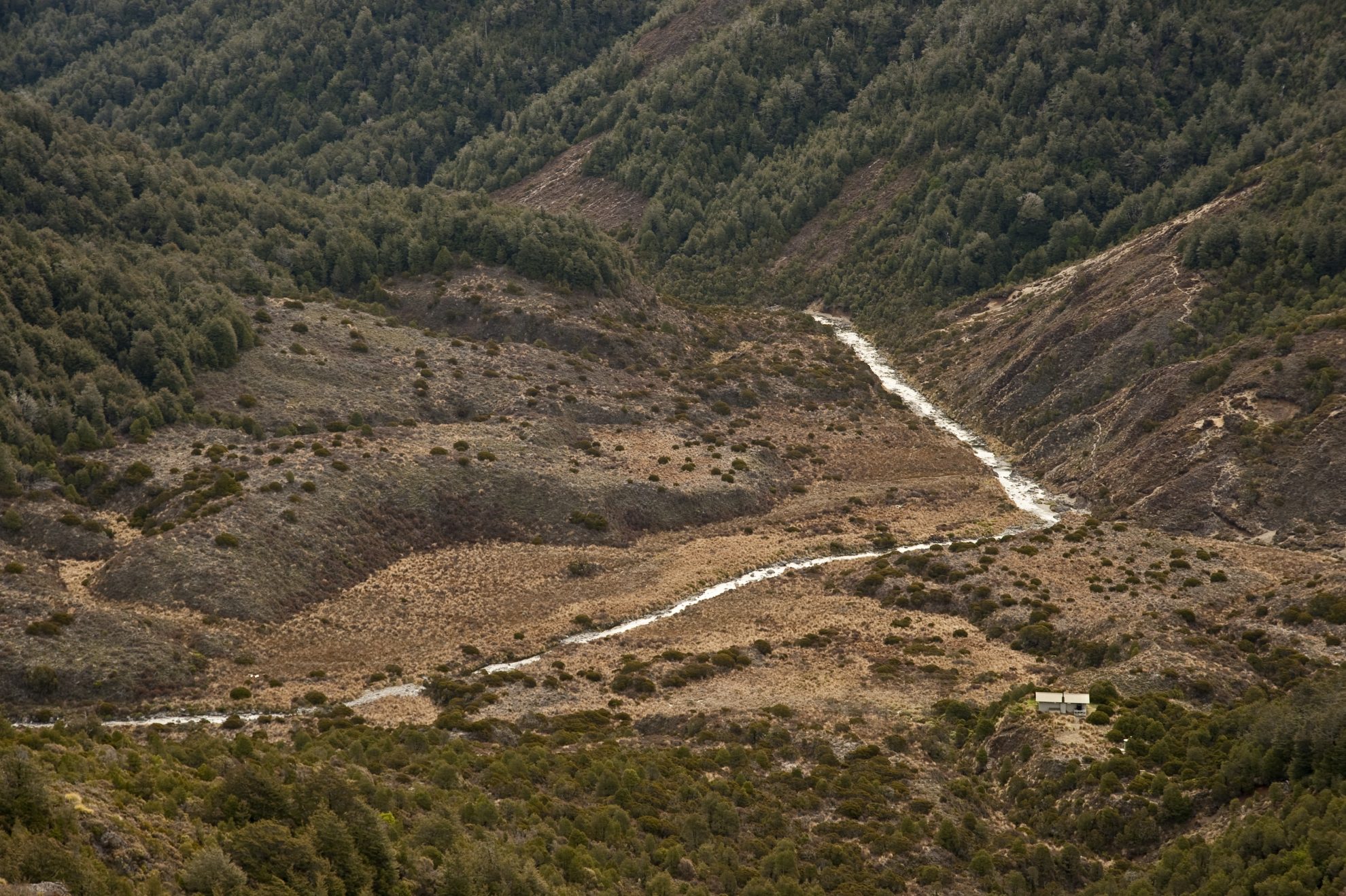
February: Waipakihi Hut loop, Kaimanawa Forest Park
This classic tops trip quickly takes you above the bushline for stunning volcano views – without the traffic found at neighbouring Tongariro National Park.
The wide open spaces enable you to enjoy the freedom of the hills. However, this is big, deer-stalking country that demands respect. The alpine ridges are exposed to severe and changeable weather. During any season, visibility can deteriorate to zero.
The long, dry days of summer are most suitable for this expedition, before hunters arrive for The Roar (March – May), and before waist-deep snow drifts impede progress. In winter, the beautiful valley becomes a veritable freezer.
A spur track provides a steady grunt to the bushline, then poles lead past Sharp Cone (1481m) then up over Umukarikari (1591m) for panoramic views of Lake Taupo. A sharp descent into the Waipakihi River basin loses much of the altitude, as you cross the headwaters and scramble to the 12-bunk Waipakihi Hut squatting on a low tussock shelf and set back from the river.
Splashing ankle-deep down the Waipakihi River is truly a delight on a hot summer day. The valley exudes a wilderness vibe similar to many in the South Island. The meandering river has chiselled its way through layers of pumice and ash from the Lake Taupo eruption.
In the mid-reaches of the valley, look for the exit track which abruptly climbs onto the rolling Umukarikari tops. Here, the trig of Urchin, 1392m, provides a spectacular vantage across to the volcanoes. A short bush track descends to a different car park, where a road walk of around 60 minutes completes the circuit.
Wild file
Access 15km south of Turangi, turn off SH1 on Kaimanawa Rd.
Grade Easy-moderate
Time Two days. Car park to Waipakihi Hut, 5hr; To car park via Urchin, 7hr
– Raymond Salisbury
March: Tara Tama, Westland
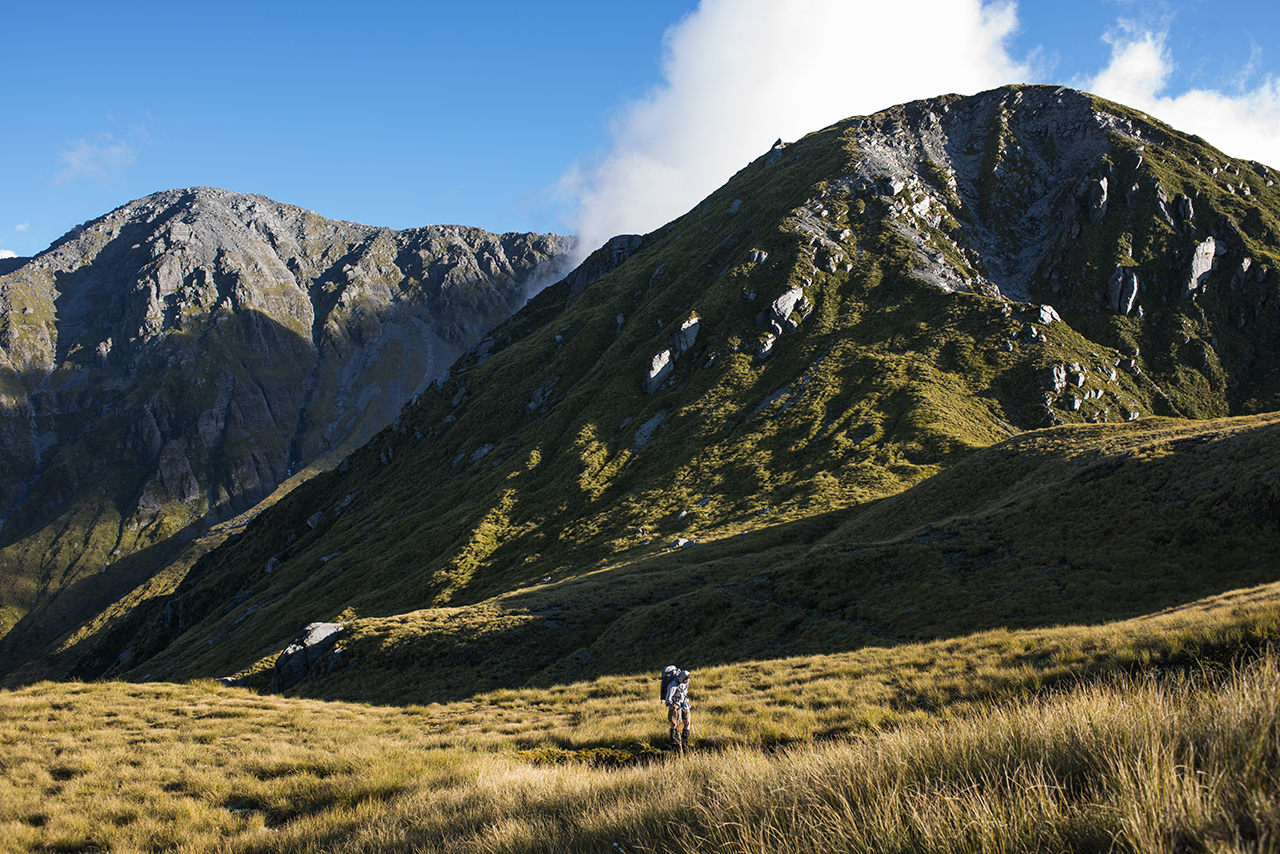
At 1854m, Tara Tama is not high by Southern Alps standards, but with over 1600m of vertical ascent along a tortuous ridge, you may see why this remote outlier of the Main Divide is seldom climbed. For all that, March provides a period when rivers are low, the weather is more settled and a little cooler for high, open tops travel.
From SH73, the easy track follows the Taipo River until just before Dillons Homestead Hut, where the river must be forded – a challenge that can end the trip before it has even started. The Taipo drains a massive area of Arthur’s Pass National Park and often carries a substantial volume of water. However, in low to moderate flows, a good ford can usually be found just downstream of Seven Mile Creek.
Once across, an old, roughly-marked and difficult-to-find track climbs a spur to the bushline at 1000m. Here begins six kilometres of meandering skyline traverse, all the way to Scottys Saddle.
Cloud often hugs the high ridges here for days at a time, making progress difficult and sometimes dangerous. A tiny two-bunk bivvy is sited 200m below the ridge-crest in the head of Scottys Creek. This section and the summit push itself are the most spectacular and rewarding parts of the trip. As the ridge heads south-west, a sheer scarp to the north allows unobstructed views over northern Westland and toward the
Tasman Sea, a truly breathtaking sight which broadens in spectacle as the long summit ridge is gained.
Care is required as ridge rents and teetering, house-sized boulders line the route and sometimes require small diversions. The summit is broad and flat with a view of the Alps and foothills that is unrivalled in this part of the Divide – enjoy it.
There are options for a round trip, but all require care and sound navigation skills. One is to descend into the head of Dunn Creek near Dunn Saddle, which requires returning along the summit ridge to Pt1751, or descending from Pt1612, east of Tara Tama, directly south into a creek running into Dunns Creek about 500m west of Dunns Creek Hut.
However you cut it, Tara Tama is a big mountain offering a demanding ascent through fantastic terrain.
Wild file
Access From SH73 west of Jacksons Tavern
Grade Moderate-difficult
Time 2-3 days. Taipo Valley flats to Seven Mile Creek, 2hr; To Scottys Bivouac, 6-7hr; To Tara Tama 2-4hr; To Duns Creek Hut via Pt1612, 4hr; To Seven Mile Creek 4-5hr
– Pat Barrett
April: Gillespie Pass Circuit, Mt Aspiring National Park
It’s best to walk the 58km Gillespie Pass Circuit during the shoulder season, between the busy summer season and the quiet, dark winter when avalanches make the crossing of the pass dangerous.
This perennial classic can be walked in either direction, starting from the settlement at Makarora. To avoid a tedious slog along the Wilkin Valley Track, cruise up the Wilkin River on a jet boat, disembarking opposite Kerin Forks Hut. From here, the track is well-built, gradually gaining the grassy flats of Siberia Valley where Siberia Hut sits in prime position.
Timing is critical, as you need reasonable weather to cross Gillespie Pass (1600m). If you have to wait, enjoy a refreshing dip in the triple-tiered waterfall nearby. Or take a day trip to Crucible Lake, which involves a steep climb to a hanging valley. The teal-blue melt-water of the lake is cluttered with icebergs.
The route over Gillespie Pass is a punishing 1000m climb, gradually zigzagging up a forested spur before topping out into open tussock. The final push for the pass may require kicking steps in snow, then hopping along weathered schist slabs to reach the flat ridge-top. Mt Awful (2192m) dominates the basin. Keep your eyes peeled for tiny rock wren searching for insects amongst the nooks and crannies.
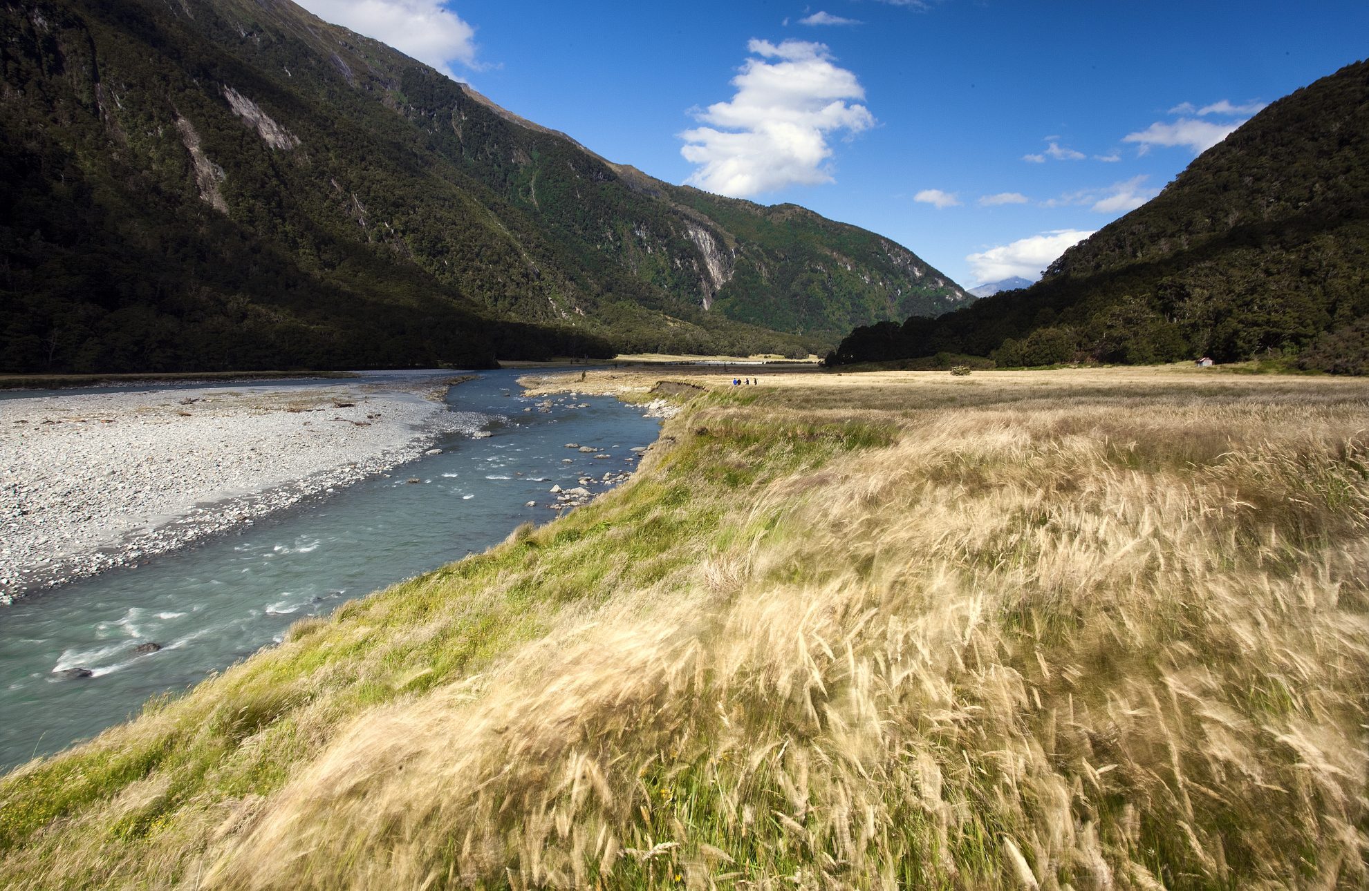
The steep, knee-jarring descent down snowgrass into the Young Valley is mercifully short. Boulder-hopping and route-finding are straight-forward alongside the roiling Young River. The track now plummets into the forest to reach the Young Hut.
On the final stretch, a large cooking shelter makes for a good lunch stop. Eventually, the track spits you out at the river mouth.
Scout for a suitable crossing of the Makarora to gain SH6, where you can hitch-hike back to your car.
Wild file
Access Trackhead and jet boats at Makarora
Grade Moderate-difficult
Time 3-4 days. Jet Boat to Kerin Forks, 1hr; To Siberia Hut, 2hr; To Crucible Lake, 4hr; To Young Hut, 6-8hr; To SH6, 5-7hr
– RS
May: Turtons Saddle to Redcliffe Saddle,Hakatere Conservation Park
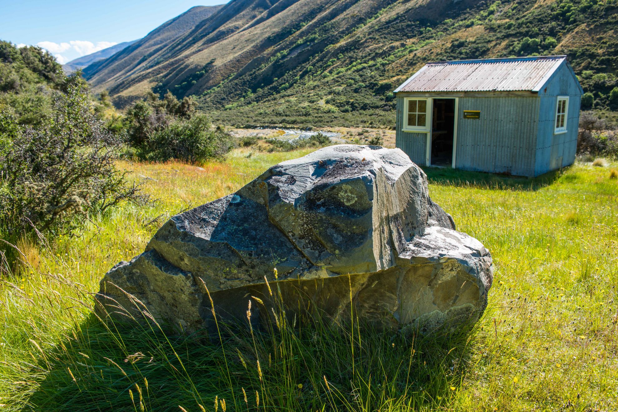
The Canterbury high country is best in autumn when the red tones add to the space, beauty and grandeur of the Alps and foothills. With a good forecast, cold, clear nights, vast starry skies and crisp days make for ideal tramping conditions. With low, albeit cold, river levels, it’s also the perfect time to walk the meandering river circuit between Redcliffe and Turtons saddles.
Being able to negotiate the tight gorge sections along the southern-most part of the unmarked route is only possible in low river flows. This, in fact, is the allure of the tramp – a great, bare, treeless landscape, dominated by peaks up to 2000m through which the tortuous river-route winds – sometimes on tracks and 4WD trails, other times in and out of the river, forging your own way through. Adding to the charm and yesteryear feel, each night is spent in a restored musterers hut.
Beginning on the south bank of the Rakaia River, a marked easement heads into Glenrock Stream where a poled route (part of the Te Araroa Trail) leads to the summit of Turtons Saddle, 1100m. This high point of the journey is worth the steady uphill grind as it has a grand view and a spacious location among tussock-covered ridges. The landscape is unrelentingly empty; a good point to keep in mind should you come during windy or cold conditions as other than the huts, there is no shelter.
Below the saddle is A Frame Hut and later Comyns Hut, a larger shelter with a grand outlook onto the mountains. South of Comyns, the TA trail heads west while the unmarked route travels into the small gorges of the Ashburton River North Branch where the river is constricted. This section is slow and exciting with a few short wades and the occasional scramble until Cookies Point is gained and the Swift River junction.
Travel is then again in the riverbed, but now much easier, up to Tribulation Hut and finally over Redcliffe Saddle track to the road.
Wild file
Access Glenrock Stream or Redcliffe Stream on Double Hill Run Road
Grade Easy-moderate
Time Three days. Road to A Frame Hut, 4.5hr; To Comyns Hut, 2hr; To Cookies Point, 4-6hr; To Tribulation Hut, 2-3hr; To road via Redcliffe Saddle, 3hr
– PB
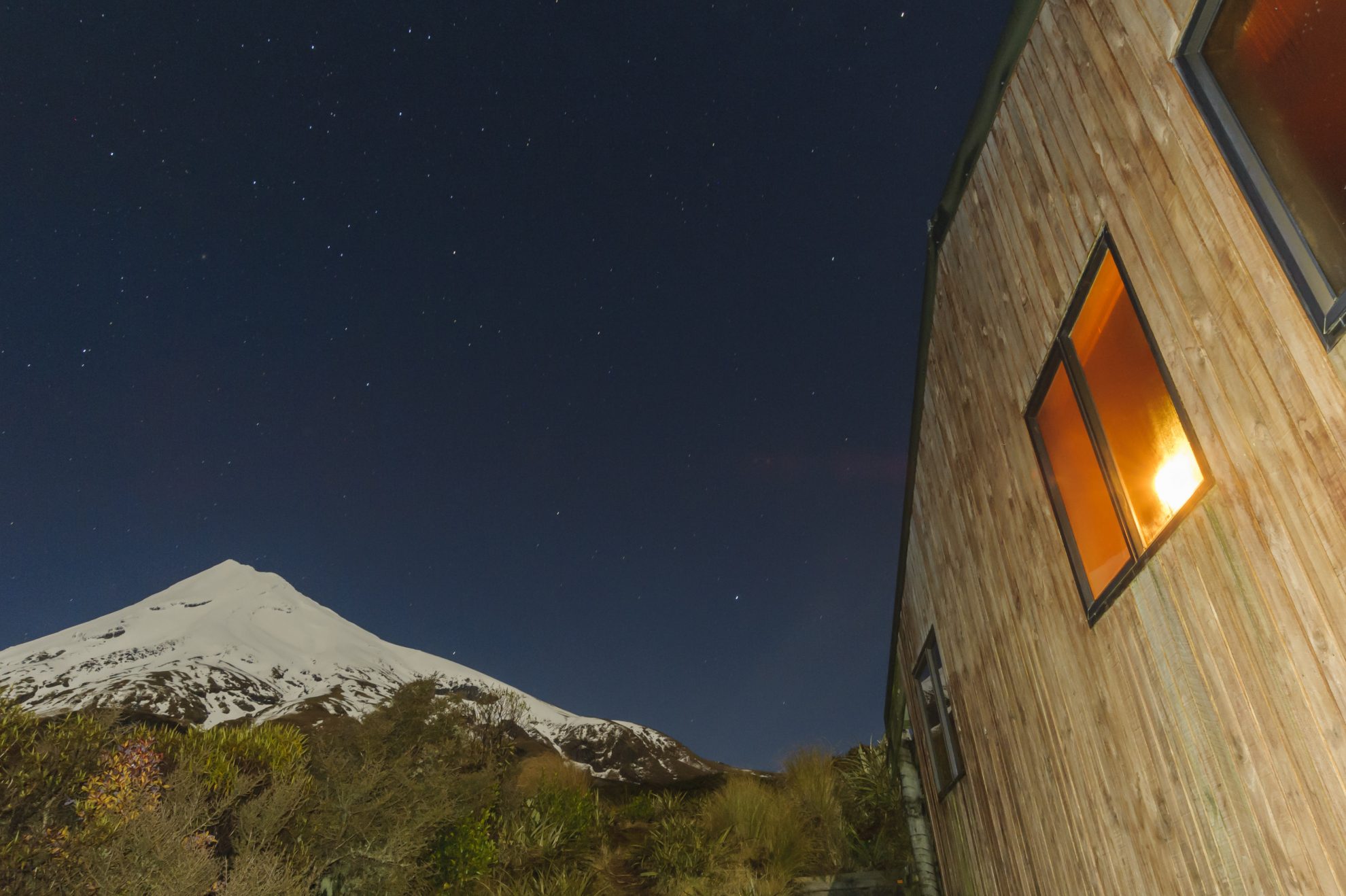
June: Maketawa and Waingongoro huts, Egmont National Park
Where to head in winter where you can rely on a comfortable and warm hut, and views of a snow-capped volcano? These two huts make an excellent choice because of their easy all-weather access. Both are reached after a short tramp, with a minimum of effort and without problematic river crossings en route. And both face superb aspects of Taranaki, perhaps the quintessential New Zealand volcano.
Trampers headed for a night at Maketawa Hut have a choice of routes, best decided after consulting the forecast. In good weather, take the Translator Road Track, which is also the main route to the summit. After crossing a footbridge over one of many incised streams, the route climbs steadily to a junction with The Puffer. From here, it’s an easy downhill stroll through subalpine shrubs to Maketawa Hut, set at the lofty altitude of 1000m.
A highlight will be watching the snow gleam under a sprinkling of stars, or the dawn sun paint its eastern faces. To complete the circuit, take the Maketawa Track to North Egmont.
By staying in the forest, this track provides a sheltered, all-weather option during inclement weather. At this altitude, the vegetation is famed for its distinctive ‘goblin forest’ appearance: mossy and stunted totara and pahautea intertwined with broadleaf species.
The tramp to Waingongoro Hut also features goblin forest. Before setting off, it’s worth making a side trip to Dawson Falls, a 16m horsetail that spills over a volcanic bluff. Then, with packs cinched, head up the Wilkies Pools Track – a picturesque series of cascades, scalloped out of the volcanic rock – paying close attention to the signposts at each of the many track junctions. From the pools, take the Ridge Loop Track until its junction with the Waingongoro Track. It’s then a steady downhill plod to the hut. En route, detour onto the swingbridge over the Waingongoro River, which offers a disarming view of the defile more than 20m below your feet.
Like Maketawa Hut, Waingongoro occupies an excellent position with views of the eastern slopes of Taranaki rising to Sharks Tooth.
Wild file
Access Maketawa Hut is reached from North Egmont. Waingongoro Hut is reached from Dawson Falls or East Egmont.
Grade Easy
Time To Maketawa Hut, 1.5-2hr; To Waingongoro Hut 1.5-2hr
– SB
34 years of inspiring New Zealanders to explore the outdoors. Don’t miss out — subscribe today.

Questions? Contact us


