Bell Rock Track, Boundary Stream Mainland Island Reserve

April 2018

Read more from

April 2018

Standing beside the aptly-named Bell Rock. Photo: Heather Whelan
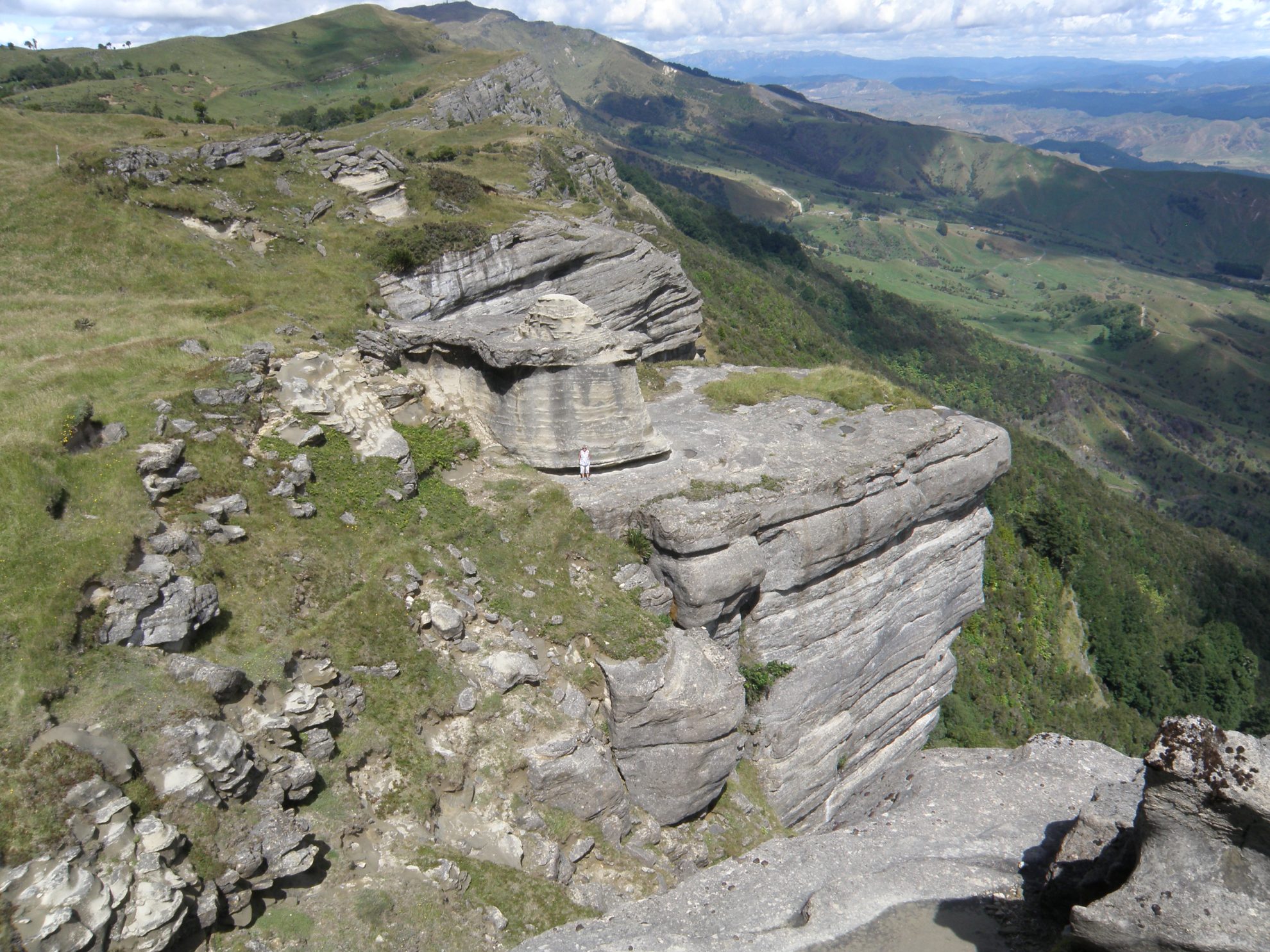
A track to make your head ring

Pick a sunny day to walk the Bell Rock Track to be rewarded with spectacular views of the Hawke’s Bay countryside.

The Boundary Stream Mainland Island is protected by a predator-proof fence, providing a safe haven for at least 24 species of reintroduced native birds. They appear to be flourishing – among our tally were kaka, tui and bellbird.

From the roadside parking area, the track immediately enters beech and podocarp forest and leads gently upward for about 30-40 minutes. As elsewhere in the reserve, this area of bush has numerous traps for stoats and rats, and bait stations are laid out. It also has wooden weta houses attached to trees.

The path abruptly emerges into open grassland where a stile and DOC posts mark the route uphill. About 50m further on is a track junction marked by a sign showing Bell Rock Track to the left, a 30 minute uphill walk.

This section of the track crosses retired farmland, a marked contrast to the shady, green forest, but we were given wide views in all directions.

Just when we thought we were at the highest point, the track unexpectedly dips into a wide, grassy gully, but the marker poles could be seen going up the other side. A little further on, there is another stile and, finally, the most breathtaking views of the tramp. Ahead is a sheer drop into the valley, edged by weathered and sculptured limestone formations. Bell Rock is obviously named for its resemblance to a huge bell, the sort that hang in church belfries. Scrambling down to it, we could see the fossilised remains of shellfish embedded in the limestone, a look into New Zealand’s turbulent geological past.

After some exploring, we found a place on the ledge around Bell Rock to eat lunch and admire the view, which extends from Mahia Peninsula to Cape Kidnappers in one direction and the inland ranges stretching towards the Central Plateau in the other.

We then retraced our steps to the DOC sign, which indicates that a loop track would take us to Pohokura Road.

– Heather Whelan

Distance
4.4km
Total Ascent
277m
Grade
Easy
Time
3hr return
Access
From Napier, drive 43km on SH2. Turn at Tutira onto Matahorua Road, then left on to Pohokura Road. The track begins 16km down this road
Map
BH39

GPX File

Bell Rock (gpx, 97 KB)

GPX File

Your device does not support GPX files. Please try a different device.
Alistair Hall

About the author

Alistair Hall

More From Trips

Related Topics

Similar Articles

New tramping scholarship for aspiring writers and photojournalists announced

Nobody wants to ban kids from reading Wilderness

Pigeon Post, January/February 2026

North Whetu Bivouac, Kaweka Forest Park

The best trip on Topo50 map BL36 – Norsewood

Mangatainoka Campsite, Kaweka Forest Park

Trending Now

Walk1200km‭ ‬in 2026

Apply for the Shaun Barnett Memorial Scholarship

Upgrading to ultralight without replacing everything

50 great walks for kids

From peaks to beaks

Subscribe!
Each issue of Wilderness celebrates Aotearoa’s great outdoors — written and photographed with care, not algorithms.Subscribe and help keep our wild stories alive.

Join Wilderness. You'll see more, do more and live more.

Already a subscriber?  to keep reading. Or…

34 years of inspiring New Zealanders to explore the outdoors. Don’t miss out — subscribe today.

Your subscriber-only benefits:

All this for as little as $6.75/month.

1

free articles left this month.

Already a subscriber? Login Now