
A few minutes further on lay Lake Diana. Then, at a junction, we dropped our packs to lope up to Lucidus Lake. At 828m it’s impressive, and more than 1.5km long, with Mt Pollux soaring 1760m above and a large moraine wall to the east. The turquoise waters were irresistible in the midday heat and provided the first of many swims.
From the junction, a trail leads up through dense scrub beside the Wilkin River North Branch. Where it emerged into a broad basin, I climbed the eastern side of the moraine to get a different perspective of Lucidus Lake. Just like the moraines in Aoraki / Mt Cook Nat-ional Park, the lakeside moraine wall was huge, steep and falling apart. At the northern end a hanging glacier perched precariously above the lake. In the heat, big chunks of ice were carving off and crashing into the water. Looking back the other way, beyond the basin, we could see a steeper route that picked its way through rocks to a narrow gut, from which Lake Castalia gushed, beginning its life as the Wilkin.
On our second evening, having retraced those steps, we camped on the true right of the Wilkin, just east of Jumboland. It was tranquil and a lovely evening, but now, down below 500m, we had company as thousands of sandflies gate-crashed our party.
We didn’t linger before setting off for the Siberia Valley the next morning, and a couple of hours, mostly through forest, found us at Kerin Forks Hut. Just across the Wilkin, passengers bound for the Siberia disembark from jetboats. By now we’d made countless river crossings and were used to wet feet, but this one proved the deepest. We ended up dog paddling, our packs providing floatation. Caro is smaller than me, so I came back for her pack so she could swim across. The cool water was no hardship.
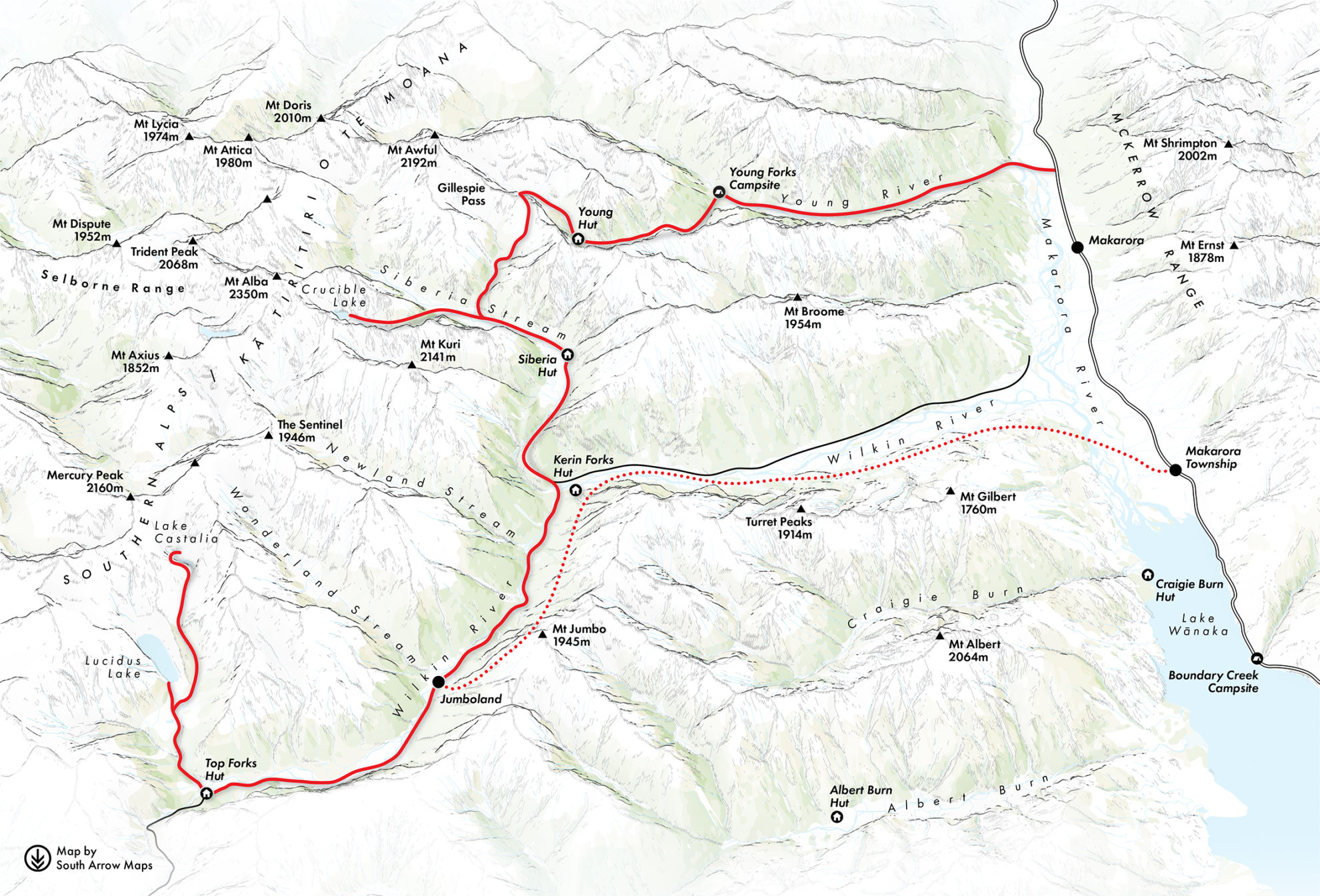
Only two hours was needed for the steady 500m climb to the Siberia Valley on an immaculate track. After another swim in a deep, gloriously clear pool, just upstream from a flock of paradise shelducks, we called in to Siberia Hut before forging on to find a campsite.
Our plan was to exit via Gillespie Pass into the Young, so it made sense to park up for the night at the base of Gillespie Stream. A well-used grassy pad and improvised seating suggested others had done the same. But there were sandflies. Many, many sandflies.
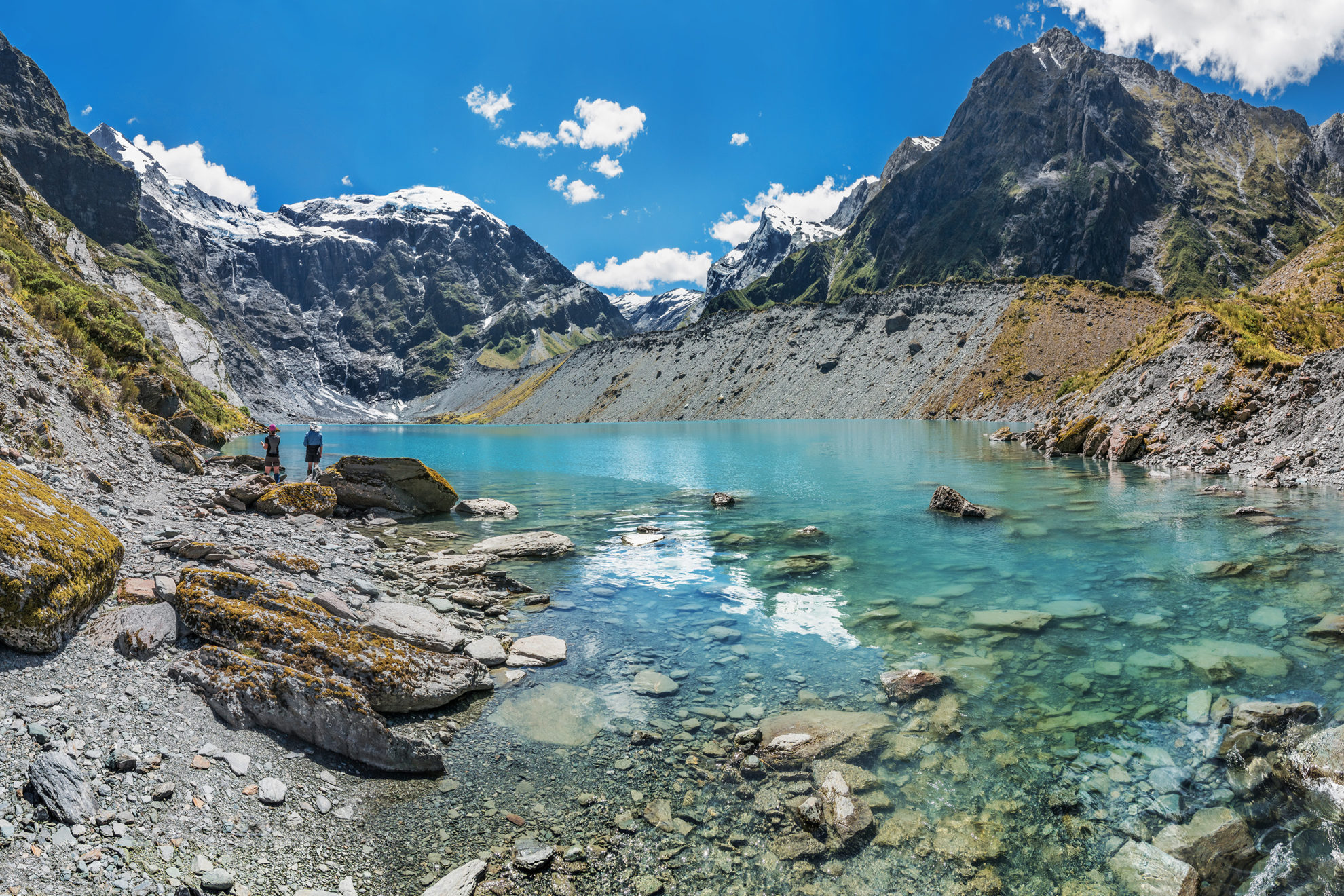
Before departing the Siberia, we had to visit Crucible Lake – it was, after all, our original objective. The lake is a popular day walk from Siberia Hut for good reason. From the valley floor, the trail climbs steeply over boot-worn, contorted and interlocked tree roots for 350m. Beyond the tree line is a huge cirque with an impressive lip concealing Crucible Lake. On three sides tower near-sheer cliffs, culminating in Mt Alba’s permanent snows at 2360m.
“I reckon that’s a route down that rib on the east side,” Simon hypothesised.
Simon’s route looked pretty bluffy on parts of Alba though. It was disappointing not to reach that lofty point. But standing safely on the crater-like rim surrounding the deep blue-green waters of Crucible Lake offered consolation. Small icebergs floated serenely, their perfect doubles mirrored on the glassy surface. Suddenly, all that serenity was destroyed by Simon’s bare rear as he plunged into the icy water. Caro and I remained above the water line, amused by the mildly shocked expression on Simon’s face before he quickly climbed back out.
Down in the valley once more, we retrieved our packs and made a beeline for open ground near the stream bed where we could have some lunch without becoming lunch ourselves. We still swatted a fair few tiny black marauders, but not the hordes of the evening before.
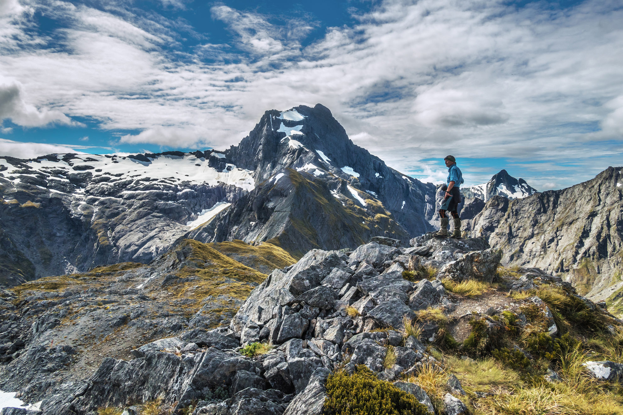
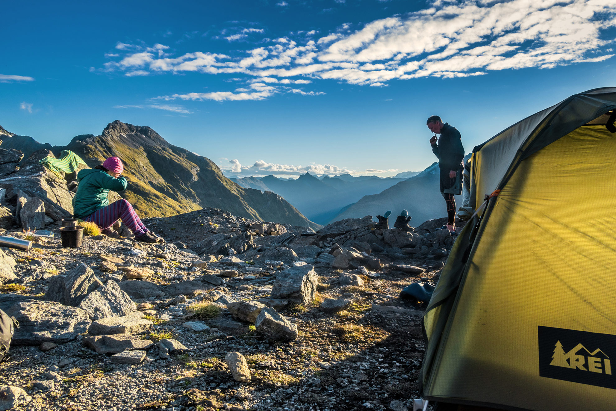
The first spits of rain fell just as we shouldered our packs. We hoped this would pass quickly. My knees slow me down when descending, but I usually go well ascending, so I left the others behind and made my way through beech forest, then steep tussock and on to rocky terrain. The climb to the high point of the Gillespie Pass Circuit is nearly 1000m on a well-defined trail. It doesn’t actually reach Gillespie Pass (which is lower and further north), but it does lead to a superb camping spot beside a convenient slab of snow that we could melt for water. It’s a small climb below Pt1629, the high point of the track. From it is a stunning 360-degree panorama, taking in Mt Alba to the west, Mt Awful to the north, plus many other unnamed peaks and the deeply cut Gillespie and Young valleys.
At the top now, the sky was beginning to clear, with sunbeams warming up the high, rarefied atmosphere. I was dripping with sweat, so I stripped to my undies and changed into jandals, leaving my clothes to dry and giving my feet a breather – a first for me on a mountaintop.
As Simon and Caro climbed the final section, I yelled out a greeting: “Welcome to the Gillespie Hilton, with air conditioning, a sandfly-free zone, where the cocktails are ice cold and the view is truly awful!”
I knew climbing a huge hill with a pack isn’t Caro’s favourite pastime, so I’d melted a Gillespie Hilton cocktail to perk her up. We soon set up camp and began to enjoy the ever-changing dusk views.
The pre-trip forecast had warned of deteriorating weather with significant rain by evening on our fifth day. At dawn, however, it was completely calm and clear. Nevertheless, that forecast provided an incentive to get moving. We had a solid 10-hour day ahead to get out before rain could swell the ford at the Makarora River, which flowed between us and the car.
With Mt Awful presiding, we began the relentless 600m drop into Young Basin.
Nourished by Mt Awful, the Young River South Branch begins life as a crystal-clear stream, meandering over open grassland that was a pleasure to pass through. The terrain steepens after a small bridge and the stream becomes more muscular and menacing, plunging over huge boulders and rock formations, surrounded by dense forest. About halfway down is the new Young Hut (750m), and an hour or so further on, a bridge crossing the tributary Stag Creek.
Not long before the Young River South Branch merges with the North Branch, a steep rocky section provides a sting in the tail on this track. Beyond that, the going is flat or undulating to the Makarora River, wide and shallow where we crossed to Sawmill Flat. The wide expanse of river gravel speaks of a much more formidable beast during heavy rainfall.
Thankfully, by the time it did begin to rain heavily, I was showered, had enjoyed a meal and was sitting, feet up, dry and relaxed, with vino in hand. All that sweat, sandflies and swimming was already taking on a post-trip glow.


