Older maps had blank areas where no one had been. Today, Google Earth will ‘take’ us there, but is this an advantage?
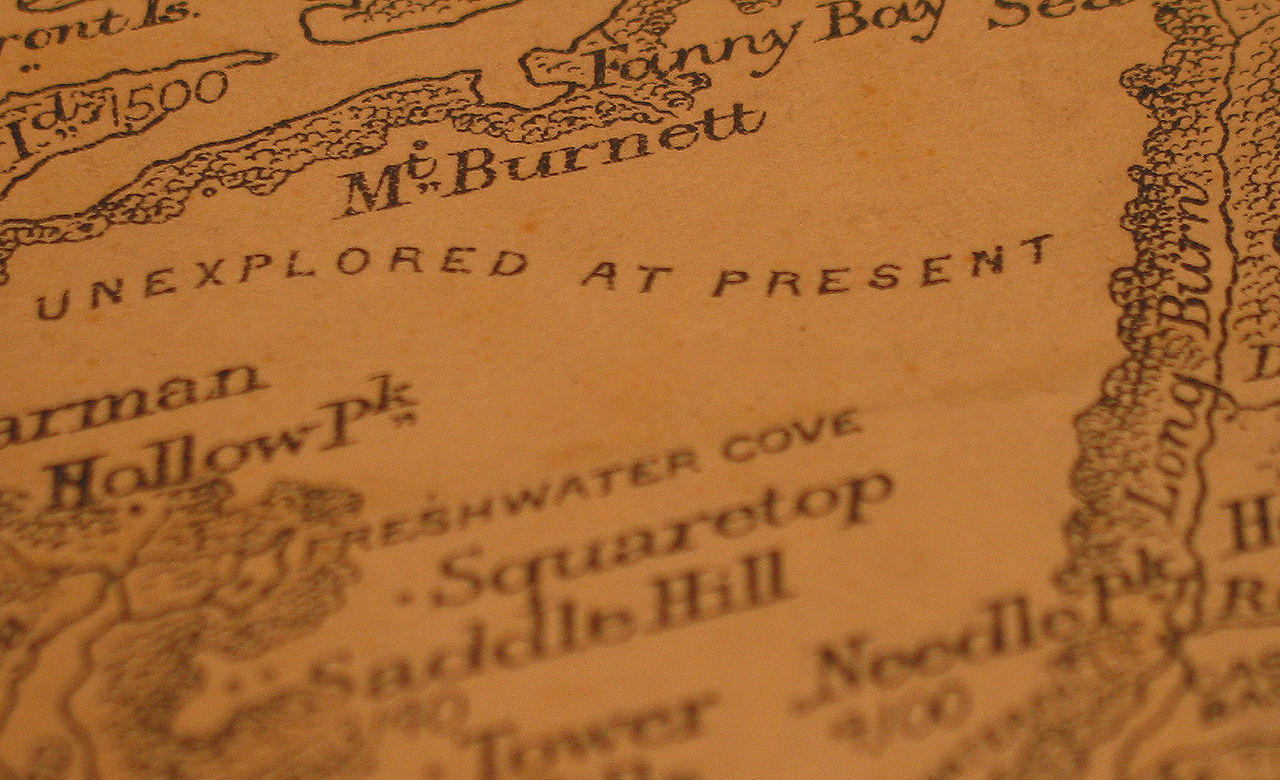
One of my favourite maps of this country accompanies the 1925 first edition of George Moir’s guidebook to the Southern Lakes. It’s beautifully drawn, with cross hatched lines indicating steep ranges, while more gentle terrain is shown as a series of undulating hummocks.
The map predates the all-knowing gaze of aerial photography. As a result rivers, while starting confidently at their known exits into lakes or ocean, drift unexplored and uncertainly back into the ranges, in increasingly approximate squiggles.
The names of the mountains tell you about the type of country to expect. Mount Inaccessible, The Stopper, Needle Peak and House Roof Hill won’t leave you in doubt as to the ruggedness and remoteness of the travel.
But to me the best part of the map, the part that has always drawn my eye, are the blank spaces, empty of all detail, and across which march the words ‘Unexplored at present’.
These show the most difficult spots to get access to, the parts the geologists and surveyors in their search for timber, minerals and sites for settlements hadn’t yet got to.
Moir’s map describes what was then known about the Fiordland area. But more than that, the map set the imagination going. It was an open invitation to go exploring. A map inviting action and the urge to find out what is there.
Flick through old Alpine Club Journals, and you’ll read of many adventures that take these blank areas as their starting point.
Marie Byles, in 1937, wrote of a journey west of the Hollyford, where ‘after lengthy consideration as to which was the whitest part of the map, we eventually decided on the Tutuko District, determined to the best of our ability to destroy its blankness. Some people euphemistically call this kind of thing “pioneering”, an attractive term implying a service to humanity. But, to be truthful, it is exactly the reverse. It is destroying the romance of untrodden lands, well knowing that by so doing you are depriving the rest of humanity of the same pleasure. So you realise that in writing this I am really making a boast of sin.’
Now, with the zoom and tilt functions of Google Earth we can surf any stretch of the world to see what’s there. Everywhere seems more accessible, less remote. Wilderness, rather than stretching away into the distance, appears contained – a sanctuary enveloped by development, rather than the other way around.
George Dasmann, writing in the United States, said ‘sometimes I wonder if our final act of wilderness destruction did not lie in designating formal wilderness areas for preservation. In defining the boundaries, writing the rules and publicising the results, did we not remove the last magic and make us realise that the remote and unknown was available to all.’
Perhaps in this country it’s easy to think along similar lines, where our wild areas are shrinking, with only pockets of bush remaining. But is this the case?
Just as Moir’s ‘unexplored’ areas reveal a bit of a brain fade about Maori knowledge and use of the area – as artefacts, middens and campsites since found there show – there can be a tendency to gloss over the staggering size, complexity and ecological diversity that our public conservation lands have. And how deeply significant they are for not just this country, but also the planet.
Imagine if we were to discover, hidden just out east in the Pacific, an archipelago of ancient islands that were by and large untouched, unspoilt, and the direct ecological descendants of the earth’s ecosystems as it was 80 million years ago.
Where on some islands giant snails live, elsewhere the largest of ferns, the cleverest of parrots, and the last of the dinosaurs. And which joined together was bigger in area than Ireland or Scotland, or Switzerland and Denmark combined.
Yet that is what this country’s public conservation lands are. A network of amazingly diverse places like Taranaki, Ruapehu, the Tararuas, Orongorongos and Matiu Somes. And which, if you head south, is one long unbroken chain of forests and mountains stretching from Kahurangi all the way to the Waitutu.
Nor are these 8,700,000ha an unchanging desert or snowy tundra. Rather they’re a spectacular tapestry of rainforest, mountainous ranges, wetlands and coast, populated with species not found anywhere else on the globe.
How would we act if such a discovery were made today? Given all we know about ecology and human impacts, what activities would we allow in these islands, and how would we look after them? Would it be more of the land clearances, milling and mining that came with the maps the surveyors and settlers made? Or would there be a different approach?
Nor is this a hypothetical question. Environmental debates across the country are heating up. DOC managed to block the Mokihinui dam project, but Conservation Minister Nick Smith has traded the Denniston Plateau for a $22 million boost to DOC’s work. More proposals for mines, dams, and roads on conservation land are likely. Just how we look after these lands while also allowing them – precious in global terms – to shape us, remains a work in progress.
In 1925, Moir’s map inspired people to get out and explore. It’s worth considering what a map of today’s conservation lands inspires us to get out and do.


A river rules my life