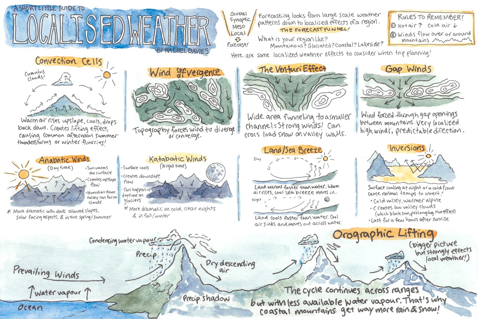
Global Synoptic → Meso → Local Forecast
Forecasting looks from large-scale weather patterns down to localised effects of a region.
The Forecast Funnel
What is your region like?
- Mountainous?
- Glaciated?
- Coastal?
- Lakeside?
Here are some localised weather effects to consider when trip planning!
Convection Cells
Cumulus clouds! Warm air rises upslope, cools, drops back down. Creates lifting effect, causing common afternoon summer thunderstorms or winter flurries!
Wind Divergence
Topography forces wind to diverge or converge.
The Venturi Effect
Wide area funneling to a smaller channel = strong winds! Can cross load snow on valley walls.
Gap Winds
Wind forced through gap openings between mountains. Very localised high winds, predictable direction.
Anabatic Winds (Daytime)
Sun warms the surface → Creates upslope flow → Humid air from valley can form clouds. More dramatic with dark coloured slopes, solar-facing aspects, & in the spring/summer.
Katabatic Winds (Nighttime)
Surface cools → Creates downslope flow → Can happen anytime on glaciers. More dramatic on cold, clear nights & in fall/winter.
Land/Sea Breeze
Day: Land warms faster than water. Warm air rises; cool sea breeze moves in.
Night: Land cools faster than water. Cool air sinks and moves out across water.
Inversions
Surface cooling at night or a cold front causes normal lapse rates to invert. Cold valley, warmer alpine → Creates low valley clouds (which block sun, prolonging the effect). Last for a few hours after sunrise.
Orographic Lifting
Bigger picture but strongly effects local weather!
Prevailing winds push water vapour up a slope → Water vapour condenses, creating precipitation → Precipitation shadow on the leeward side → Dry descending air. The cycle continues across ranges but with less available water vapour. That’s why coastal mountains get way more rain & snow!
Rules to Remember!
- Hot air ⬆️, Cold air ⬇️
- Winds flow over or around mountains


