
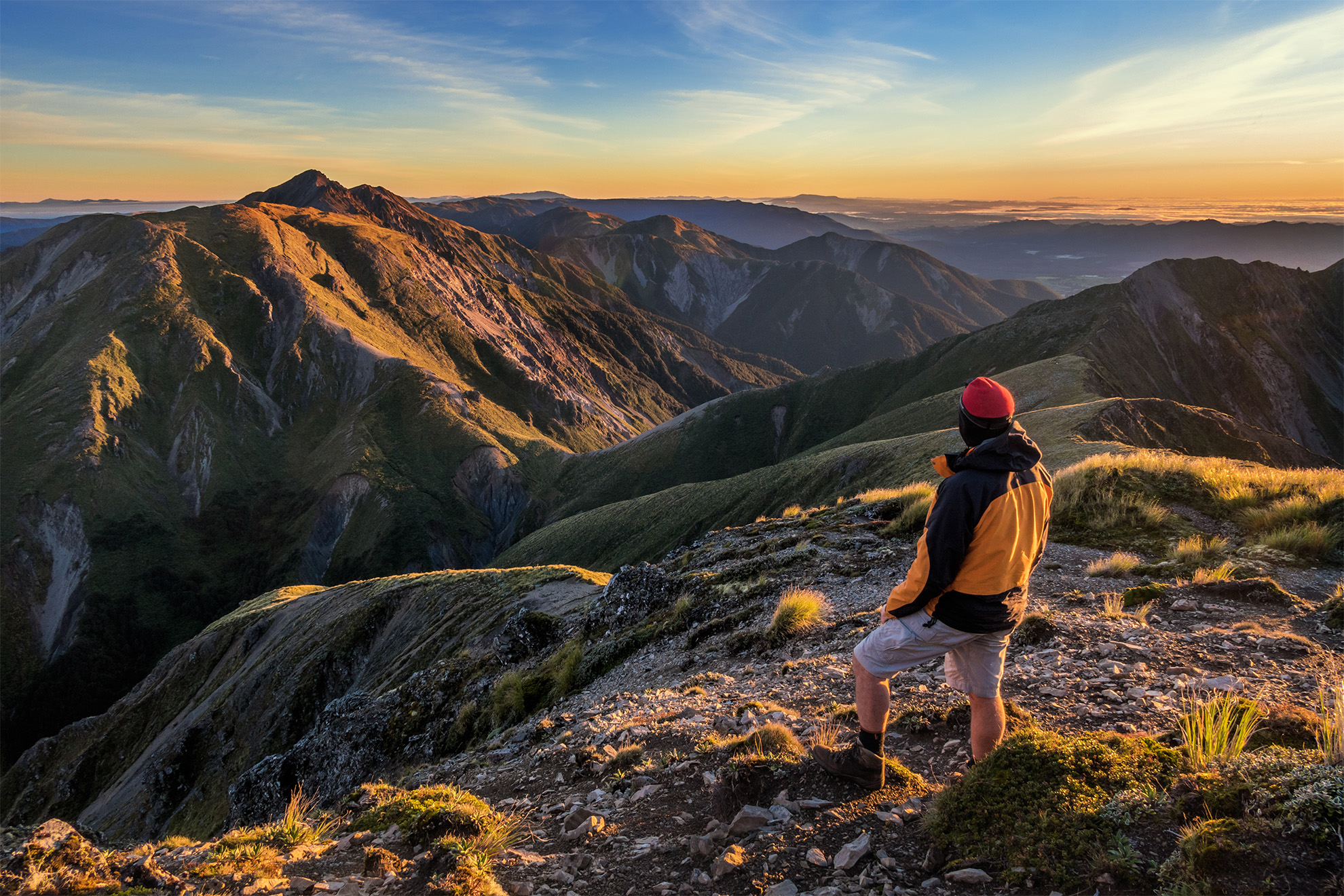
This trip, from Nina Valley swingbridge via Sylvia Tops and Devilskin Saddle is a true backcountry adventure with challenges and striking, beautiful, scenery.
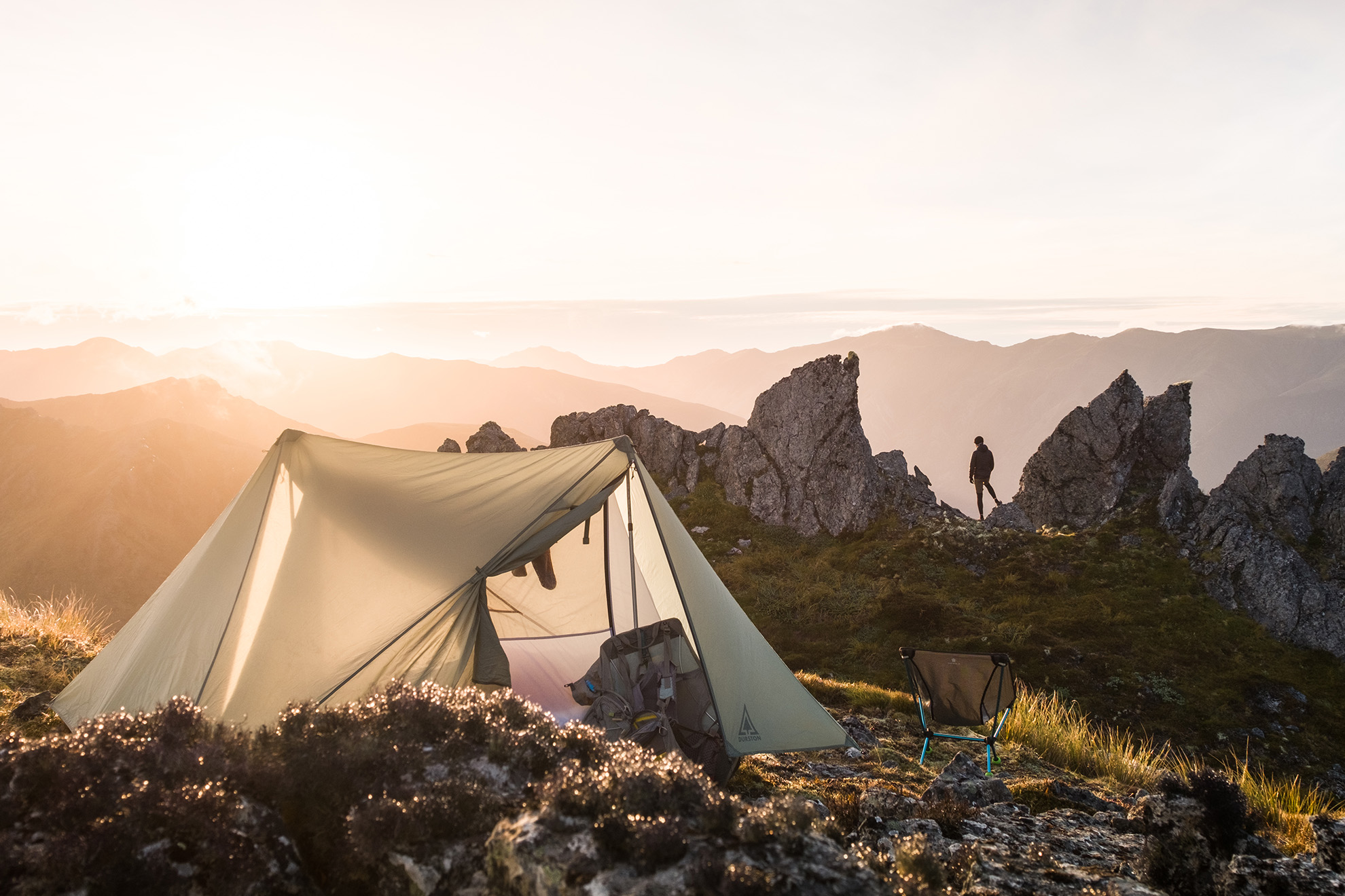
There’s an extraordinary campsite on the undulating ridgeline of Sylvia Tops tucked near a rock formation east of Pt1662. These towering rock spires are a rare sight in this part of the Southern Alps. The campsite has space for just a couple of tents, and small stagnant tarns provide a limited water supply.
Navigation is key on this tramp. About 2km from the swingbridge, trampers must locate the turn-off to Sylvia Tops Access Track, and finding a safe river crossing can be difficult. The trail to the tops can also be faint. However, once above the treeline, simply follow the ridgeline to Pt1662. The terrain’s shape encourages circumnavigating Pt1662 to the north. Instead, make sure to ascend Pt1662 from the east to reveal the spires.
A loop can be made by descending to Devilskin Saddle from where a track leads to the Nina Valley Track. With its rugged terrain and unusual rock formations, this is an ideal loop for those wanting the wilder side of the Southern Alps.
Access Palmer Lodge on SH7, Lewis Pass
Grade Moderate–difficult
Time 6hr to Pt1662; 12hr for the full loop
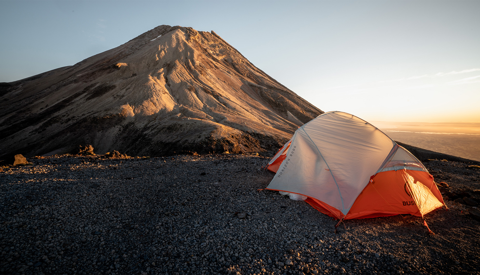
Fantham’s Peak Track is a challenging yet rewarding tramp, and it’s a must-do. There will be panoramic vistas stretching to Mt Ruapehu and, on a clear day, the South Island.
The 500m-wide flat top of Fanthams Peak (1966m) provides an excellent camping experience.
The journey starts at Dawson Falls Visitor Centre with a steady climb through beech forest. When the Kapuni Lodge turn-off is reached, the track becomes a steep scree slope with a 600m vertical ascent that makes up the majority of the climb.
Wind is a significant factor when camping on Taranaki Maunga and should not be underestimated. Syme Hut is only a few minutes away and offers a base for windy conditions.
Access Dawson Falls Visitor Centre, Pembroke Road end
Grade Moderate
Time 5–6hr return
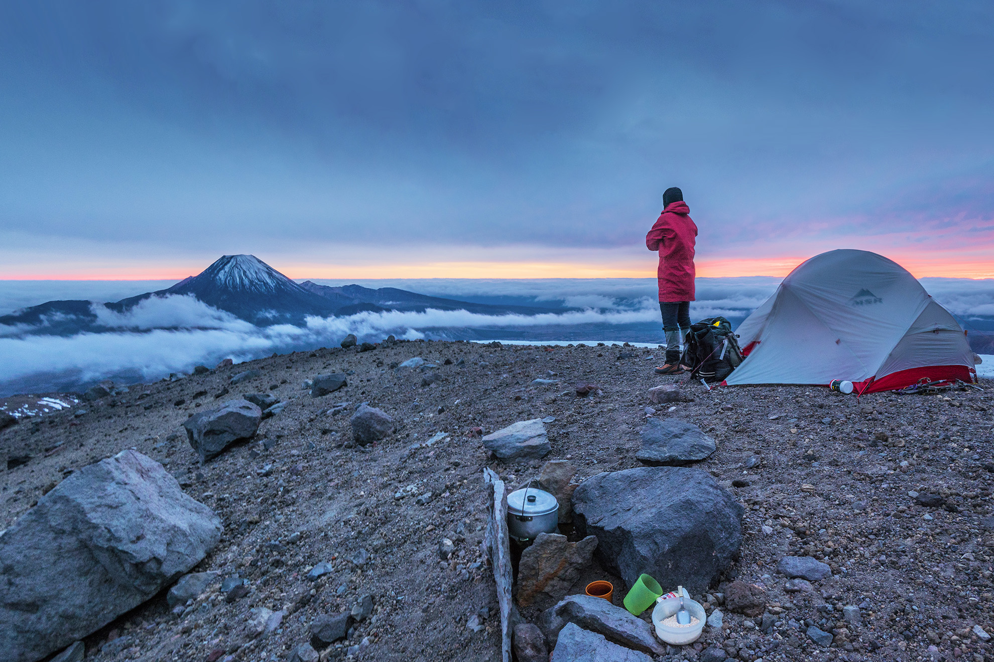
Waihohonu Ridge is a less-travelled way to the Summit Plateau of Mt Ruapehu via Te Heuheu. The broad ridge has plenty of good camping spots, especially around 2000m where there are unobstructed views north to Mt Ngāuruhoe.
Get there by driving a 4WD up the Tukino access road to the junction with the Round the Mountain Track. Then tramp north for just over 3km to the stream intersecting the track between Pt1337 and Pt1301 (grid reference 294 533). Head west up the stream for 2km to a point where there is a gap in the bluffs on the northern side of the stream. Climb out of the stream and follow the cliff edge up towards Waihohonu Ridge. The terrain is open and rolling, but bluffs present a real hazard if there is poor visibility. In clear conditions the landscape is a volcanic wonderland.
In winter there should be snow for water, but in summer the streams on either side of the ridge may be dry. The ridge, like most of the flanks of Mt Ruapehu, is exposed to the elements.
Access From Tukino Ski Field road
Grade Moderate
Time 4-6hr
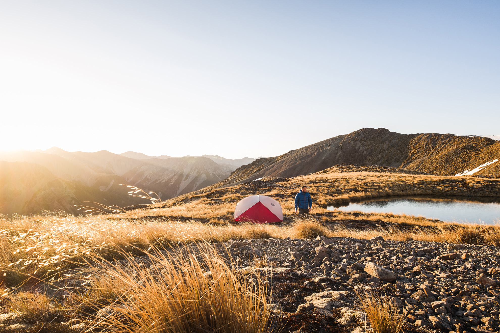
A walk to the tarns above Lagoon Saddle provides wide views across the Waimakariri River Valley and to the Southern Alps.
Starting on the Cass–Lagoon Track, the route ascends gently to Lagoon Saddle. From there, navigating the open tussock requires map-reading skills (a great opportunity for novices to hone their navigation).
When the Cass–Lagoon Track turns south towards the saddle, keep heading west, by-passing the lake near the saddle at its northern edge. From there it is a straightforward ascent to the tarns. Make sure to stick to high points near the saddle as lower areas are boggy.
After a steep but technically easy scramble, there are excellent camping spots among the group of tarns. With its relatively easy access and sweeping alpine views, this tramp is perfect for those seeking beauty and adventure.
Access The DOC car park on Cora Lynn Road, off SH73
Grade Easy–moderate
Time 7hr return
There are six high points over 1700m in Ruahine Forest Park that provide some of the North Island’s most spectacular alpine terrain and viewpoints. One spot for an overnight bivvy is beside a small tarn that lies between Rangioteatua (1704m) and its unimaginatively named companion, A6G4 (1715m).
The climb begins at the end of North Block Road and traces Waipawa River up to Waipawa Saddle at 1326m. The river is quite open to start, but expect to get wet feet. As the saddle is approached, the route becomes steeper and looser underfoot, and eventually joins a steep path through dense leatherwood. From Waipawa Saddle, head southeast up the scree slope towards Three Johns. Turn southwest at about 1500m to follow the main ridge to Pt1635, and then on to Rangioteatua. The terrain is open but unmarked; in case of low cloud, a map, navigational gear and the ability to use them are essential.
Access From North Block Road end
Grade Moderate
Time 6hr
Keen trampers who seek to bag the highest peak in every national or forest park could visit Mt Stokes (1203m), the loftiest hill in the Marlborough Sounds.
Gnarly silver and mountain beech preside over a rooty, muddy path up the spur to Ōkoha Saddle. Punch through leatherwood beyond the treeline, then cross a fence and traipse through tussock to the summit trig, adjacent to the radio repeater mast.
There is scant shelter from the wind and no water source, but on a bluebird day, there are spectacular 360-degree views. You’ll see the coastline of Wellington, the Cook Strait ferry slipping into Tory Channel; the sprawl of Picton’s outlying suburbs; and the stark profile of Tapuae-o-Uenuku dominating the southern horizon.
Access From Linkwater take Kenepuru and Titirangi roads
Grade Moderate
Time 3hr to summit
Mitre (1571m) is the highest point in Tararua Forest Park, yet the trail to it from Mitre Flats Hut, which requires a 1200m climb, is not particularly steep.
An undulating 3hr trudge along Barra Track ends at Mitre Flats Hut. Then, it’s another two to three hours to the summit. The tussock top is exposed, so watch the weather. There is no water or toilet, so be prepared.
Mitre sits to the east of the main range and offers great views north across Table Ridge to Arete and Bannister, and south to the Three Kings, the Broken Axe Pinnacles and McGregor. The lights of Masterton twinkle to the east at night.
Access From The Pines, at the end of Upper Waingawa Road
Grade Moderate
Time 6hr
This lonely 1386m mountain has become a popular alternative to climbing Roys Peak. It rises above The Neck, where lakes Wānaka and Hāwea almost join. From the remote summit, Tititea Mt Aspiring is visible among a plethora of peaks in the Southern Alps.
A public easement over private farmland allows access to the tops. Take the Isthmus Peak Track, which runs above the bush-clad slot canyon of Stewart Creek. This poled spur route skirts a deer fence and features sloping slabs of Otago schist. Sidle left for 1km to join a 4WD track that climbs through grassy slopes via switchbacks.
The gradient eases after a couple of hours at a long-drop, where a remarkable rock tor frames Lake Hāwea, 1000m below.
At the junction on the skyline ridge, turn north along tussock tops for 1km to the marker pole on Isthmus Peak.
Return to the junction and head south along the undulating ridgeline for 8km to the Matatiaho Conservation Area where camping is permitted (Pt1271 and further south).
Note: these tracks are closed for fawning between November 20 and December 20. There is no water on this exposed route, but there is cell phone reception.
Access SH6, 30min from Wānaka
Grade Moderate
Time 3–4hr to top; 5–7hr to conservation area
It’s one of the best wild camping spots in the country, but requires a demanding climb of Mt Fox (1021m).
Afternoon cloud can obscure the landscape on the West Coast, so wild camping provides more opportunities to enjoy clear morning views of Te Moeka o Tuawe Fox Glacier, Horokōau Mt Tasman and Aoraki Mt Cook.
Starting from a tiny car park near Fox Glacier township, you are immediately swallowed by the great green forest and will later face a series of vertical rock steps with good handholds. After about three hours on the marked track is a trig station above the scrubline. It’s another hour’s climb following blue and orange markers to a smattering of small tarns at the 1345m contour, which is a logical place to camp.
Access 3km from Fox Glacier village
Grade Moderate
Time 3–4hr to tarns


