


With the creation of the impressive 90km Motu Trails loop, Opotiki is finding a new lease on life as a mountain biking destination
Opotiki proudly faces north, collecting the first rays of the morning sun as it rises over the Bay of Plenty. Sandwiched between the Otara and Waioeka Rivers, the town has survived many floods and storms to rebuild and move on. It was once Eastland’s major port and populated centre, but this, along with other industries and services, drifted west to Whakatane and Auckland.
These days, the town is chocka over the summer with people flocking to its beautiful beaches, great fishing and now its incredible mountain bike tracks and trails.
The Motu Trails are three very different rides that can be enjoyed individually or ridden sequentially and clockwise to form an epic 90km loop back to Opotiki.
The three trails have their own distinct feel, scenery and soundtrack. They each require a different skill set and fitness, and reward mountain bikers in different ways.
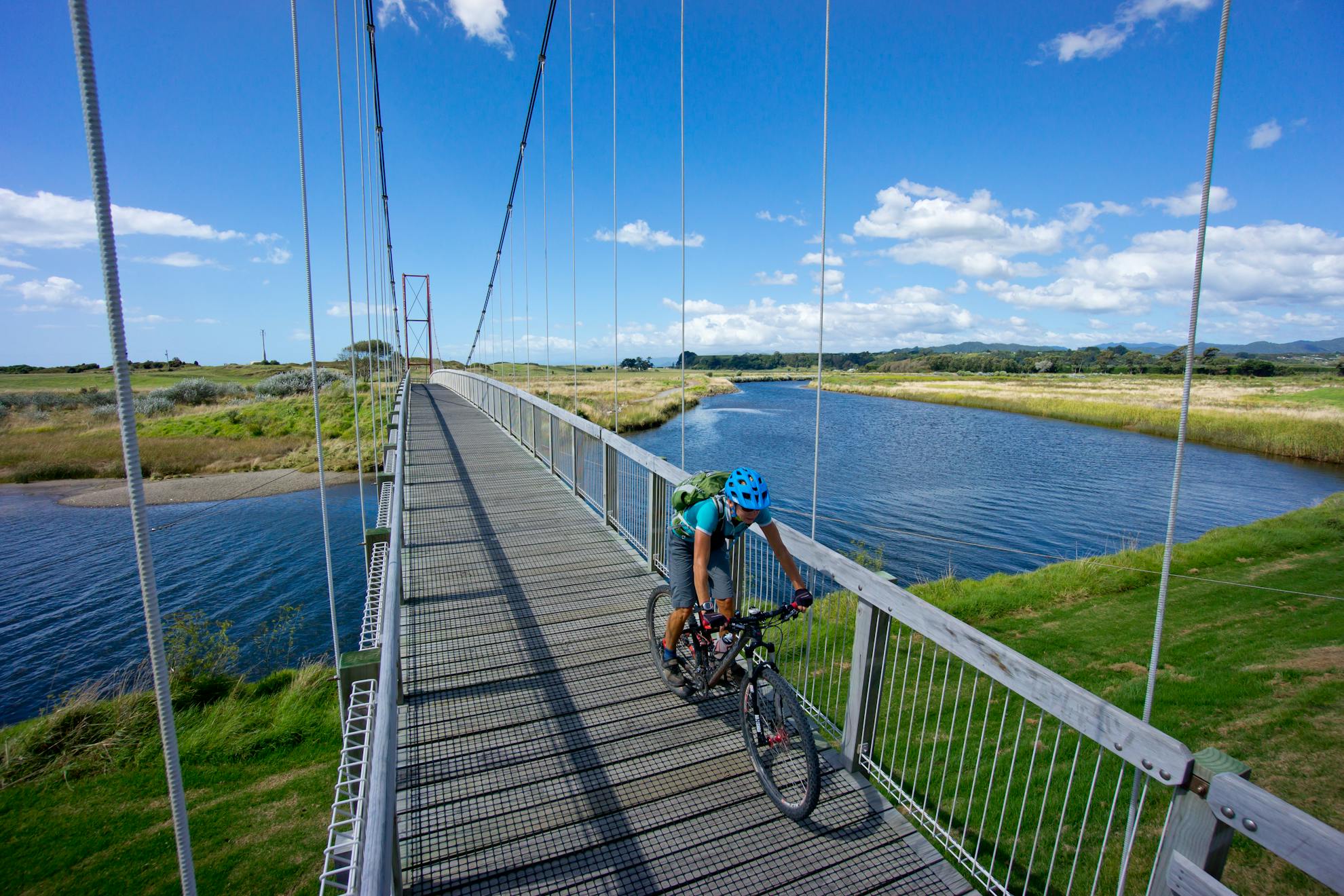
The Dunes Trail
From Opotiki to Waiaua, 10km, Grade 1-2
For absolute beginners, this beautiful section of coastline hosts a fabulous dune and beach trail. It begins by crossing a massive swingbridge that spans the Otara River before heading into the sand dunes on a ribbon of gravel through a healthy mix of coastal plant species. High dunes flow down to the wide flat sand of Hikuwai Beach and the sea. On a hot sunny day, the water is mighty inviting as the sound and smell of the surf fill the senses.
At Tirohanga, cross a small estuary where spectacular pohutukawa trees grow wildly on adjacent sea cliffs. After a sandy boardwalk section, the trail passes a very Kiwi bach settlement relaxing beside the sea.
The Dune Trail eventually ends when it joins SH35.
Motu Road Trail
Waiaua to Toatoa, 24km, Grade 2-3
From the end of the Dune Trail, take SH35 east and then turn right onto Jackson Road. This heads south for 500m, crossing the Waiaua River and onto the mythical Motu Road.
Continue south past the immaculate white Waiaua church and marae and around the base of Makeo hill and up through the last few remaining farm settlements. There, the Eastland jungle moves into remote mode.
The Motu Road is a substantial but steady climb on a single lane gravel track through some truly spectacular and rugged country. It tops out at 500m below the bush-clad Te Weraakauanga and overlooks fingers of cleared valley floor out to Toatoa settlement.
The downhill to Toatoa is short and fun but there are two more climbs before the sun goes down if you are aiming to complete the loop.
Toatoa to Pakihi Saddle, 12km, Grade 2-3
Continuing south on Motu Road, cross Papamoa Stream and climb into the Toatoa Scenic Reserve. The road ascends through a tunnel of bush to a 600m highpoint before descending into the even more remote farm settlement of Whitikau, surrounded by rolling hills and regenerating bush. At the road junction, continue uphill on Motu Road for one more kilometre to the start of the infamous Pakihi Track.
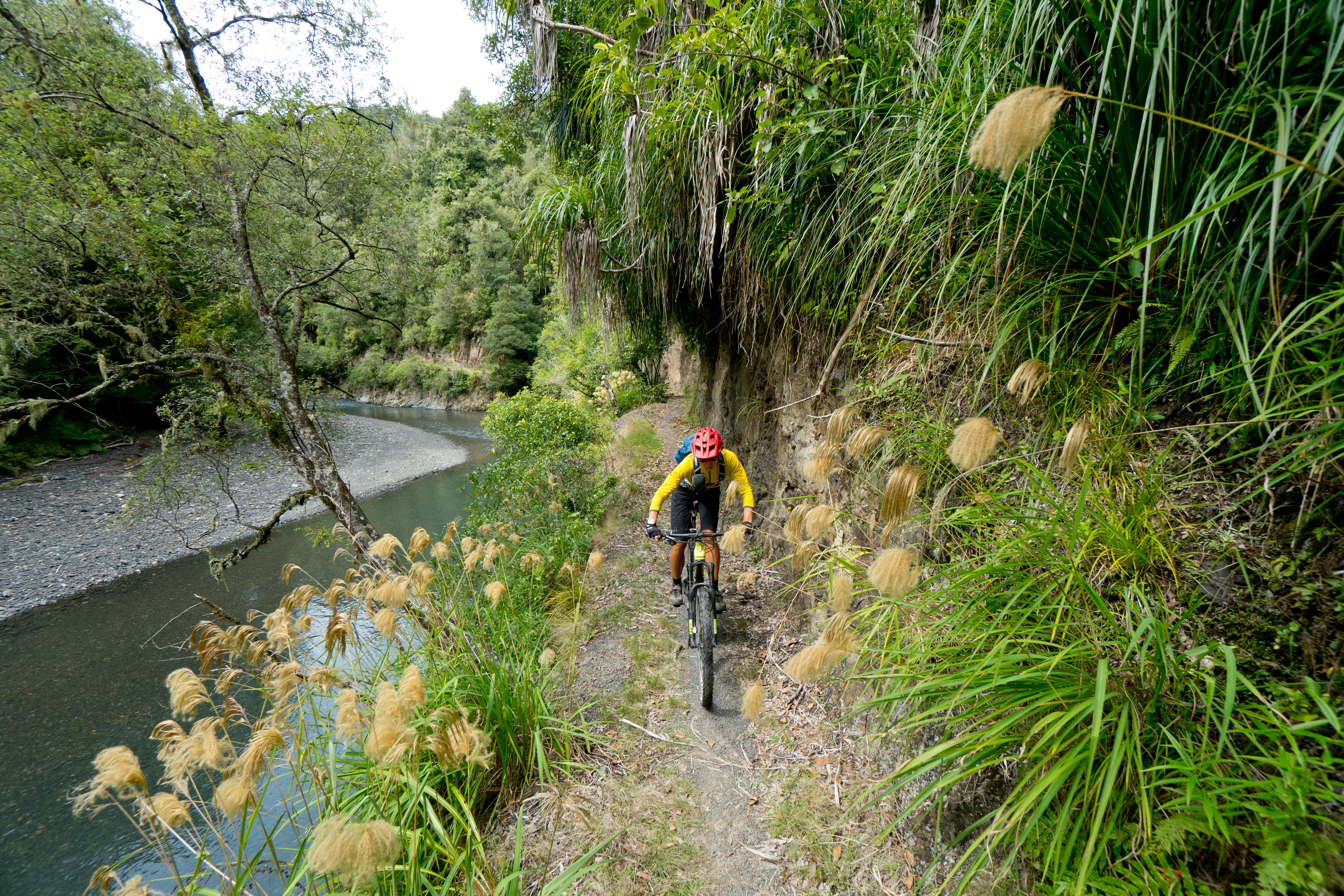
Pakihi Track
Pakihi Track to Pakihi Road end, 20km, Grade 3
The Pakihi Track is one way only – downhill – thus the required clockwise direction of the loop. The track was formed in the early 1900s to connect Motu with Opotiki but was never enlarged into a road as was hoped. The amount of dynamite used to blast the river balcony section is legendary and at the time was probably a lot of fun.
It earned its legendary status in the 1990s as an epic jungle ride, but since then a huge restoration project has added 25 bridges and the track has been re-benched. A thick forest of kamahi, beech, totara, rimu, tawa, supplejack and ferns do their best, along with the thriving undergrowth, to blot out as much light as botanically possible.
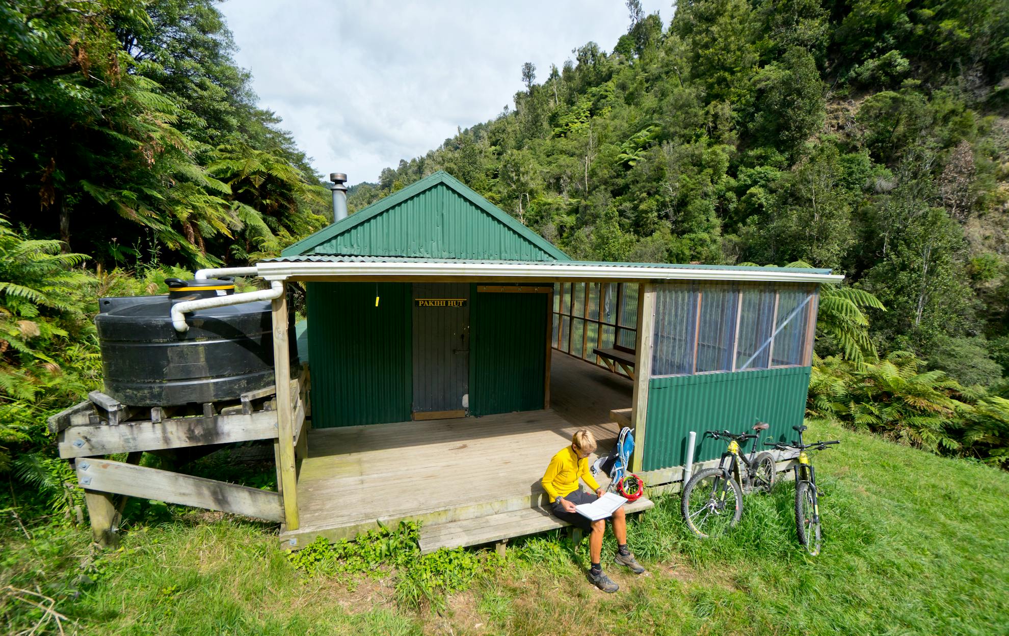
It’s a gradual descent that follows the contours in and out of every stream gully with a predominantly south facing aspect all the way to Pakihi Hut, which stands on a lone terrace high above the Pakihi River and provides great views and a spot to refuel. Below the hut, a new swingbridge makes crossing the deceptive stream a doddle.
From the hut, follow the true left of Pakihi Stream along the famous balcony section. This winds its way high above the water with steep drops and commanding views along tight gorges between Meremere Hill Scenic Reserve and Urutawa Conservation Area. Be careful here as slips and rock fall can arrive unannounced and narrow the track further.
The valley eventually opens out and the road end arrives at the confluence of Orukutia and Pakihi streams. There is a good picnic area with toilets here.
Pakihi Road end to Opotiki, 23km, Grade 1-2
A gravel road winds its way beside the Otara River and a number of farm settlements out of the Pakihi Valley, home of the legendary bushman turned author Barry Crump. At Otara, a sealed road heads back to Opotiki. Remnants of kahikatea are everywhere and would have made up a massive forest across what is now low lying farmland. At the Factory Road junction on the outskirts of town, go straight ahead on Te Rere Marae Road and hook onto the river trail that eventually delivers you back at your starting point.
- Grade
- Moderate
- Time
- 8-12hr (stay at Pakihi Hut to make it a more leisurely overnighter)
- Accom.
- Opotiki boasts numerous accommodation options and a shuttle service to get you to and from whichever sections of the track you want to ride. The six-bunk Pakihi Hut is $5/night and turns the ride into an overnighter
- Access
- From Opotiki, the whole trail is well marked from the sports fields and reserve at the north end of town.
- Map
- BE41, BF41
GPX File
- Motu Trails (gpx, )
GPX File
- Your device does not support GPX files. Please try a different device.
