


Deep in the interior of Westland/Tai Poutini National Park, in the shadow of the Main Divide, stands The Gladiator. Erik Nilsson felt it beckoning
In a state of sandfly-induced madness, we stumbled around the car park trying as quickly as possible to work out last minute logistics. What should go where and who would carry what. Recklessly throwing pieces of equipment into our backpacks, manically waving our arms and cursing loudly, we worked fast, before the winged devils could completely drain the blood from us.
It was drizzling as we started out along the southern banks of the wide and gently meandering Karangarua River. We were on the West Coast, and it was apparent.
My hiking companion, Chris, had attempted this tramp a few years prior. But two days into the trip he’d been turned back by a series of high bluffs. After days spent pouring over topo-maps, consulting weather forecasts and gaining route information from DOC, we were finally on our way.
My boots felt heavier than usual, maybe because of the mud sucking my feet back down with every step, but also the weight of six days worth of food strapped to my back. Whatever the cause, I had settled into a dark, moody silence. Despite my friend’s chipper attempts at small talk, I was beginning to have doubts about this trip.
As much as I’d like to fancy myself an avid bushman, it’s sometimes hard not to dwell on the comforts left behind. A warm, cosy apartment, a soft, comfortable down duvet and a delicious pizza at the local pub. These luxuries paraded back and forth in my mind, whilst I experienced the cold wet, slowly seeping into my boots. Not to mention the sandflies. Why was I here?
A few kilometres into the valley, at the first river confluence, the Copland Valley and its track to Welcome Flat Hut veers north while the Karangarua bears south. Despite originating in almost the same place, these two walks are completely different in nature. The Copland, being one of DOC’s flagship hikes for the Westland region, sees a high level of maintenance. Tracks and huts are maintained to a high standard. The Karangarua Valley Route, however, is rougher around the edges; the trail is often teeming with windfall and unbridged creek crossings are the norm.
By the second hour of walking, we had settled into a steady pace. The clouds had begun to part and the sun occasionally peered through an otherwise overcast sky. I was slowly realising the beauty of the region, and although I had hardly broken my morbid silence all morning, I already felt lighter of heart, the worries of day-to-day life slipping behind one after the other.
Upon reaching the Copland River confluence, the track delves into the lush rainforest. We easily crossed several small tributaries and then encountered a swollen McTaggert Creek, where, waist deep, rushing white water made for a tricky crossing. Safely on the far bank, our victory over the creek had us both laughing and, just like that, I was in the zone. Talking, joking and laughing, we made our way deeper into the valley.
Still wet and with dusk approaching, Cassel Flat Hut was a welcome sight. The hunters we found inside generously offered us freshly-cooked venison stew, which we gratefully wolfed down.
Our plan for the week was to make our way up Regina Creek on the Douglas Valley Route, cross over to the Douglas Valley and sidle the high, tussocked benches north of the river to gain access to Horace Walker Hut. From the large lake beyond Horace Walker Hut, we would mount our attack upon The Gladiator and then descend back into the Karangarua River Valley via Mt Howitt.
Immediately after flying across a roaring Karangarua River in the exhilarating cable car, we were met by a different type of track. The trail along Regina Creek is doubtlessly in less use than the fairly popular track leading to Cassel Flat. It clearly hadn’t been blazed in a few years and a steady downpour wasn’t making the going any easier.
We had opted for a late start, hoping the weather would clear before we made the climb up and over into the Douglas Valley. Arriving at the point on the trail just before the steep climb out of Regina Creek, we set up our tent beneath a half-toppled tree – the only flat-enough spot we could find. With branches and vines pressing up against the tent, it didn’t take long for water to start seeping through. It was a damp night.
We woke at the crack of dawn to a bluebird sky. The climb out of the bush, to the point just east of Conical Hill, started off relentlessly and remained so all the way to the top. The route, unnervingly, crosses active slips several times. Higher up, a metal ladder has been bolted to the rock wall, aiding what otherwise would have been a four-metre near-vertical climb with great exposure. Around this time, we broke out of the treeline and were greeted by amazing views in all directions.
Not far ahead lay one of the bigger obstacles of the trip, and one that had Chris apprehensive. We were approaching the point where his last attempt had been thwarted. The band of bluffs sits directly atop an exposed ridgeline.
Passing the bluffs involves switching from one side of the ridge to the other, multiple times. However, since Chris’ previous visit, DOC had made substantial improvements. Markers had been set up, and bush that previously had made crossing difficult had been cut and we managed to pick our way through and over the cliffs with relative ease.
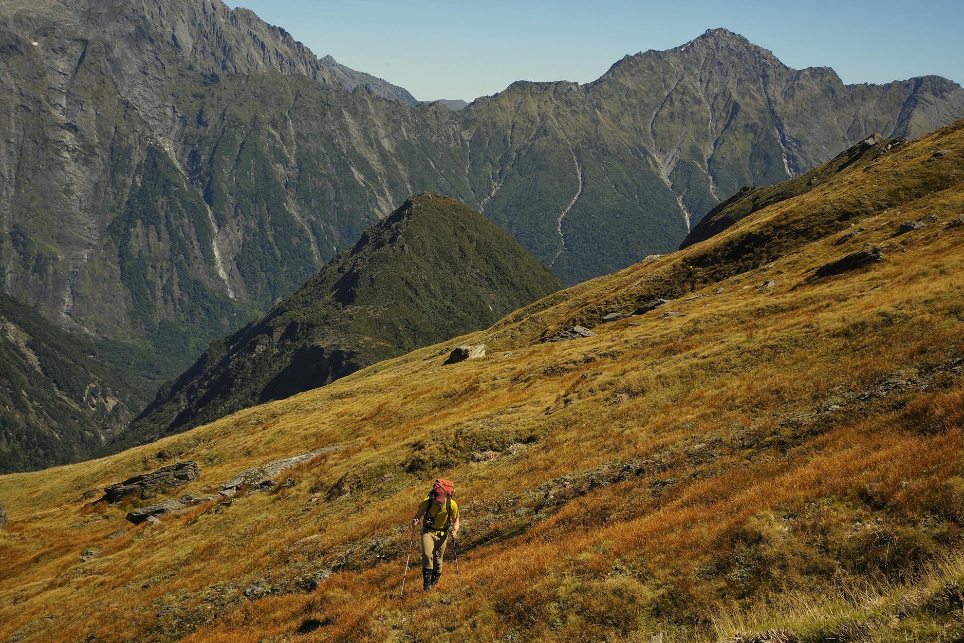
Shortly after the precarious bluffs, the trail peters into open tussock fields. The route becomes untracked here but is intermittently marked by snow poles. Trudging along at the 1500m contour, this section is nothing short of gorgeous. Gazing up and down the length of the Douglas Valley, one can keenly appreciate the raw, untamed and untouched wilderness of Westland.
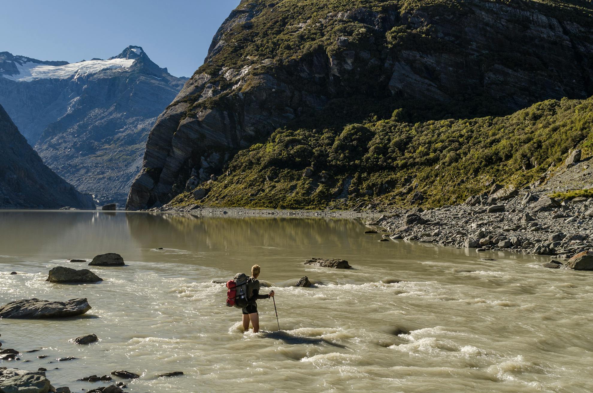
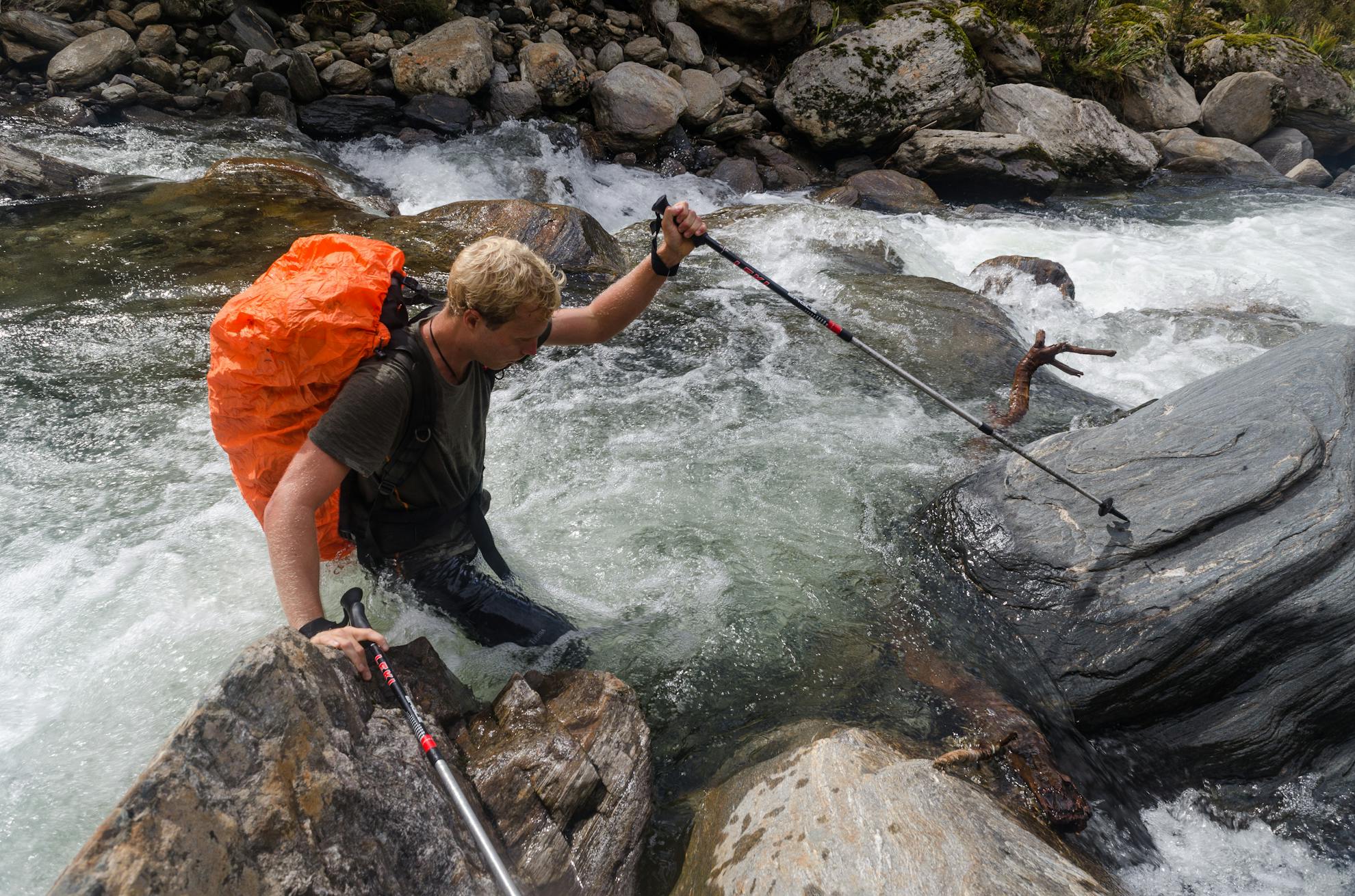
One final hurdle lay between us and Horace Walker Hut: the swift-flowing Douglas River. Linked arm-in-arm, we plunged into the icy, glacier-fed water. The strength of the current surprised us, but after a few minutes of fighting, we were safely across. We didn’t know it yet, but this was just a sample of what the next morning held in store.
We spent the night breathing in the solitude, feasting on our freeze-dried dinner by the hut’s crackling fire and reading hut book entries from bygone years.
When we woke and pressed our faces against the window, there, waiting, was yet another cloudless sky. We set off early, hoping to ford the Douglas River quickly and get our climbing underway. But when we reached the river, we found it running fast and high. We stripped down to our undies, linked arms and ploughed in. About halfway across, the water was up to our waists and flowing quickly. A few steps more and we felt a sudden drop-off beneath our feet. The silty-brown, glacial-sediment-filled water had hidden a deep channel that rendered the river uncrossable. Despite being within a few metres of the far bank, we couldn’t get across. We retreated to try crossing elsewhere and repeated this procedure several times before finally finding ourselves at the mouth of Douglas Glacier meltwater lake. Here, finally, we found a safe crossing.
Moir’s Guide speaks of a very old, marked trail starting the ascent of The Gladiator beside a waterfall. Having located the waterfall, we were bewildered when we could not distinguish any signs of a trail. Both sides of the falls were flanked by vertical walls. Gazing up, Chris caught sight of what looked to be a ribbon tied around a tree, jutting out several metres above us.
I climbed up to investigate and realised that this was indeed the point the book had referenced. All but the faintest indications of a trail ever having existed here were now replaced by nearly impenetrable Westland bush. And so began one of the toughest bush-whacks either of us had endured. At one point, we clocked ourselves gaining less than 100m in an hour.
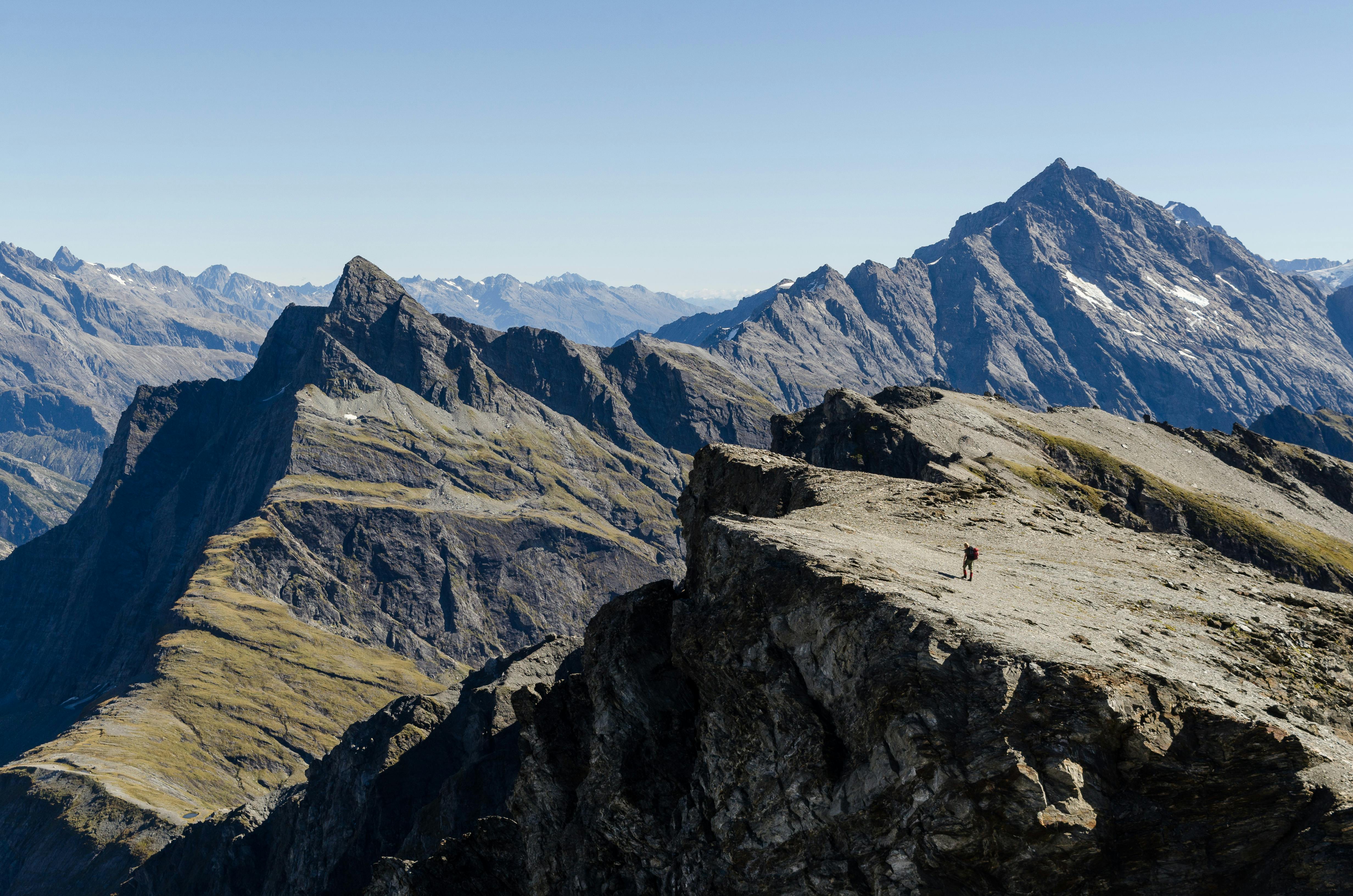
Bloodied, bruised and banged-up, we smashed our way through the final vines and brambles before breaking above the bushline. And then it was smooth sailing. With the end in sight, a wave of second wind washed over us both. Our steps found renewed purpose as we scrambled across the last several hundred metres of shingle scree and rock slabs. Looking back down the valley, we could roughly make out the path we’d been walking over the past few days, all the way down to Conical Hill.
The final push is an easy gradient and approaching the summit uncovers striking views of the Southern Alps, Aoraki/Mt Cook, Mt Sefton, the surrounding valleys as well as the Tasman Sea.
The magnificently lofty ridgeline between The Gladiator and Mt Howitt is an easy traverse with otherworldly views down the seemingly never-ending Landsborough Valley.
We found the descent to Christmas Flat Hut, at the head of the Karangarua River, nowhere near as difficult as climbing from the Douglas side.
Our final two days were abuzz with excitement over our achievement. Hiking the full length of the Karangarua Valley, with the upper section proving particularly beautiful. We spent many hours boulder-hopping along the riverbeds, which enabled faster travel than the windfall-laden and muddy trail.
As I unpacked at the car park, after six days in the wilderness, I experienced immense satisfaction bubbling up. We’d done battle with The Gladiator and come out (more or less) unscathed.
Chris suggested I join him in the car to avoid the pesky sandflies. I hadn’t even noticed them.
- Distance
- 54.4km
- Total Ascent
- 3743m
- Grade
- Difficult
- Time
- Six days. Car park to Cassel Flat Hut, 5-6hr; To Regina Creek walkwire: 2-3hr; To Horace Walker Hut, 9-10hr; To Christmas Flat Hut via The Gladiator, 10-11hr; To Cassel Flat Hut, 8-9hr
- Accom.
- Cassel Flat Hut ($5, six bunks), Horace Walker Hut ($5, four bunks), Christmas Flat Hut ($5, four bunks), Lame Duck Hut ($5, four bunks)
- Access
- Off SH6 at the Karangarua River Bridge, 26km south of Fox Glacier
- Map
- BX14, BX15
GPX File
- The Gladiator (gpx, 23 KB)
GPX File
- Your device does not support GPX files. Please try a different device.
