


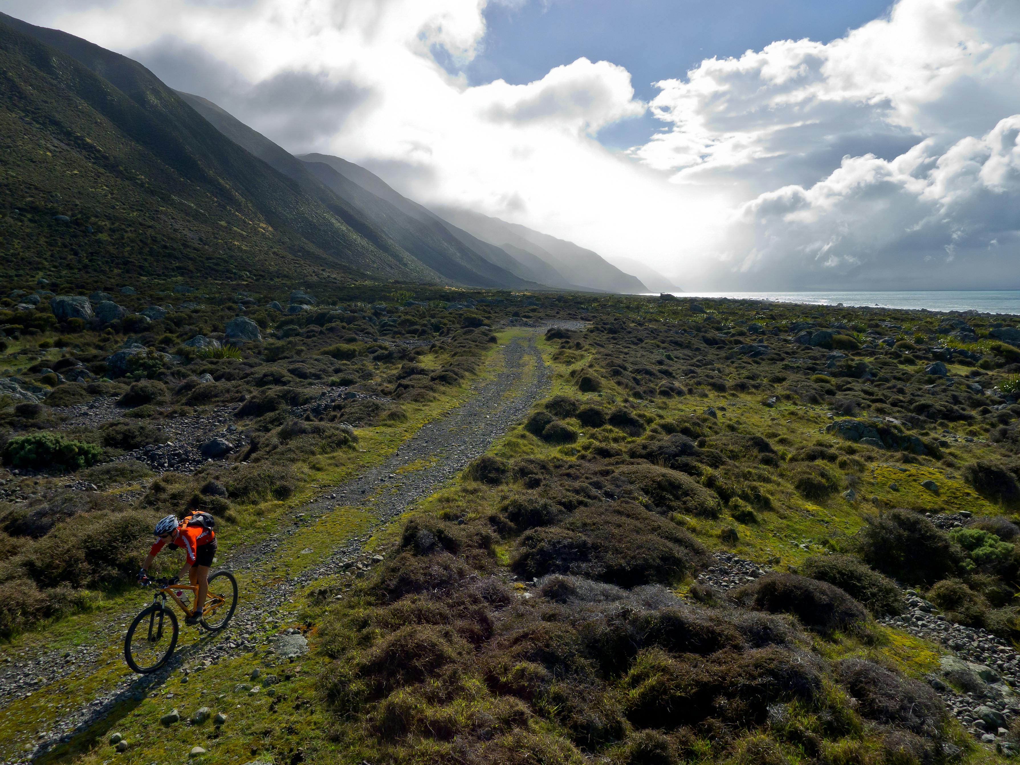

A rugged coastline provides a thrilling day ride at the bottom of the North Island
The Wild Coast Track section of the Remutaka Cycle Trail traverses a spectacular chunk of rugged coastline between Orongorongo and Ocean Beach.
Getting to the track head requires a pleasant drive along the Coast Road, through Khyber Pass, to a ribbon of slate-grey stony beach and the deep blue Cook Strait at Orongorongo.
At the car park, the adjacent Orongorongo Station dates back to the early 1800s and is one of the few original working farms. After crossing, the Orongorongo River Bridge and transferring your bike across the barrier to the access easement, a well marked fence-line track leads to the boundary of Turakirae Head Scientific Reserve.
The reserve is internationally-renowned, providing a 7000-year geological record of earthquake upheavals in the form of five raised beaches, the last formed from a magnitude eight earthquake in 1855 that raised the coast by 2.5 metres. It contains salt-tolerant herbs, tussocks and reeds, and during the winter months is home to a large colony of fur seals. Māori lived in the area as far back as the moa hunting days and from the mid-1800s it became a major route for farmers and traders between Wellington and the Wairarapa.
It’s a particularly rugged piece of coastline that has claimed the lives of many sailors on its ship-wrecking rocky beaches.
The ride continues through the reserve on a stony 4WD track before turning inland to pick up what was once the Old Coast Road. This hugs the base of the southern tip of the scrub-clad Remutaka Ranges. From Waimarara Peak, streams feed a large semi-wetland that runs for two kilometres up the coast. It is home to flax, a million toetoe and plenty of birdlife. The panoramic view extends east across Palliser Bay, then out to sea, and to the Inland and Seaward Kaikoura ranges which stretch their long legs down the east coast of the South Island.
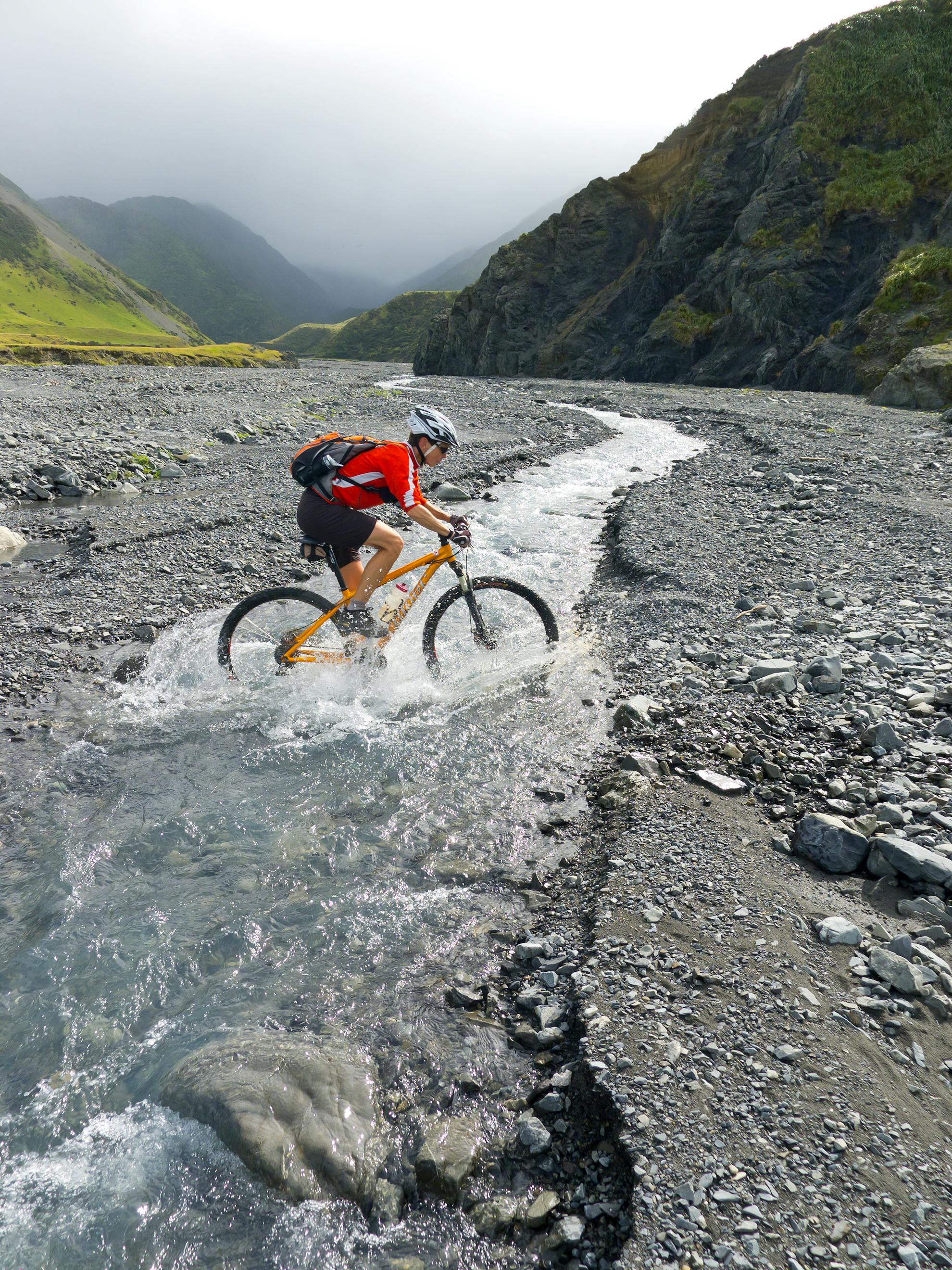
The track climbs gradually above a row of hidden bluffs from Barneys Whare Ford, eventually reaching a massive shingle and boulder fan at Kotumu Stream. You can usually find vehicle tracks or a marked route to follow over the fan and it provides a challenging piece of riding for those resistant to pushing their bikes.
Steep bush-clad slopes scarred by numerous slips climb to the main ridge as you ride below the bluff at Fishermans Rock and onto Windy Point. There’s a substantial metal gate to negotiate before attempting to ride the soft sand to the ford at Mukamukaiti Stream.
There’s a wide bay here with a long narrow track of wind-blown manuka running along the base of the hills to Mukamuka Stream. Large grassy flats provide grazing for sheep and wild goats. A second ford marks the exit from the bay and the track climbs steeply to avoid the sea’s relentless erosion of the coast. This is just a short undulating section with the odd sand trap thrown in before the terrain starts to behave itself.
The track ends at the bach settlement of Ocean Beach. These small dwellings are more in keeping with the concept of holiday cribs. They are hidden amongst the bush that flows down from Mt Matthews.
Corner Creek Campsite, two kilometres from the track end, has a shelter, table and toilets. It’s a good spot to rest before riding back to Orongorongo. Alternatively, explore further by following Western Bay Road to Lake Onoke. It’s separated by a spit from the sea and is well worth a visit.
- Distance
- 17.8km each way
- Total Ascent
- 641m one way
- Grade
- Easy / Moderate
- Time
- 5-6hr return
- Access
- From the end of Coast Road
- Map
- BQ32
GPX File
- Wild Coast Track (gpx, 9 KB)
GPX File
- Your device does not support GPX files. Please try a different device.
