


Ray Salisbury follows in the footsteps of early explorers, miners and musterers across the Lockett and Douglas ranges of north-west Nelson
Planning a journey without a map is like building a house without drawings. My index finger traces a possible route over the topographical map depicting the enormous spread of Kahurangi mountains. I count the blue squares and estimate my tops trip might last nine days. If I get it right.
It’s mid-January when a friend drops me off in Upper Takaka, laden with a heavy swag that bites into my shoulders. Filling up two drink bottles means I carry more weight, but these are soon emptied as I clamber up the Kill Devil
Track onto the open ranges. Under a lacquer of sweat, I struggle up the 69 zigzags of the bridle track which cuts a corridor through regenerating tea tree, bracken and gorse.
The recently refurbished Tin Hut provides some respite from the glaring sun. After this, the path levels and views open up into the Waingaro watershed to the west. As the trail drops through flowering manuka, more switchbacks make the descent bearable – schist is hard on leather boots.
After five hours, I follow a fence-line to find Riordan’s Hut hidden in a scrubby clearing. Built by Fred and Laurie Riordan in 1926, they grazed 2000 wethers here during the 1930s Depression. I pop inside where an armoury of ancient fencing tools, saws, mallets, shovelheads, horseshoes and a riding saddle provide an authentic aura.
In the quiet of a summer evening, I head outside. A gentle breeze caresses the plateau of second growth scrub. A creek gurgles. Car headlights on the Takaka Hill remind me of glowworms. I settle in for the night.
Kahurangi translates to ‘blue skies’ and that’s what encourages me on as I follow Fred’s fence back to the Waingaro Track. In late 1858, the surveyor James Mackay bush-bashed from the Takaka River to here, and westward to the Diamond Lakes. I am eager to try his traverse of the Lockett Range. Orienting my map, I establish a compass bearing for the next stage of off-track travel. Crashing through twisted beech forest, I notice significant pig-rooting, and have friendly encounters with fantail, robin, tomtit and bellbird.
Heading westerly and negotiating a series of bushy knobs until late afternoon, I suddenly emerge in the open, ecstatic. Seven hours of bush-bashing has left me desperately dehydrated, even after finishing my three-litre supply.
Gentle, forgiving tussock slopes make for easier progress onto a trig point, some 2km from the summit of Mt Lockett (1621m). A pair of goats scamper off the hill, and tiny rock wren flit and frolic among alpine herb fields, mountain daisy and vegetable sheep.
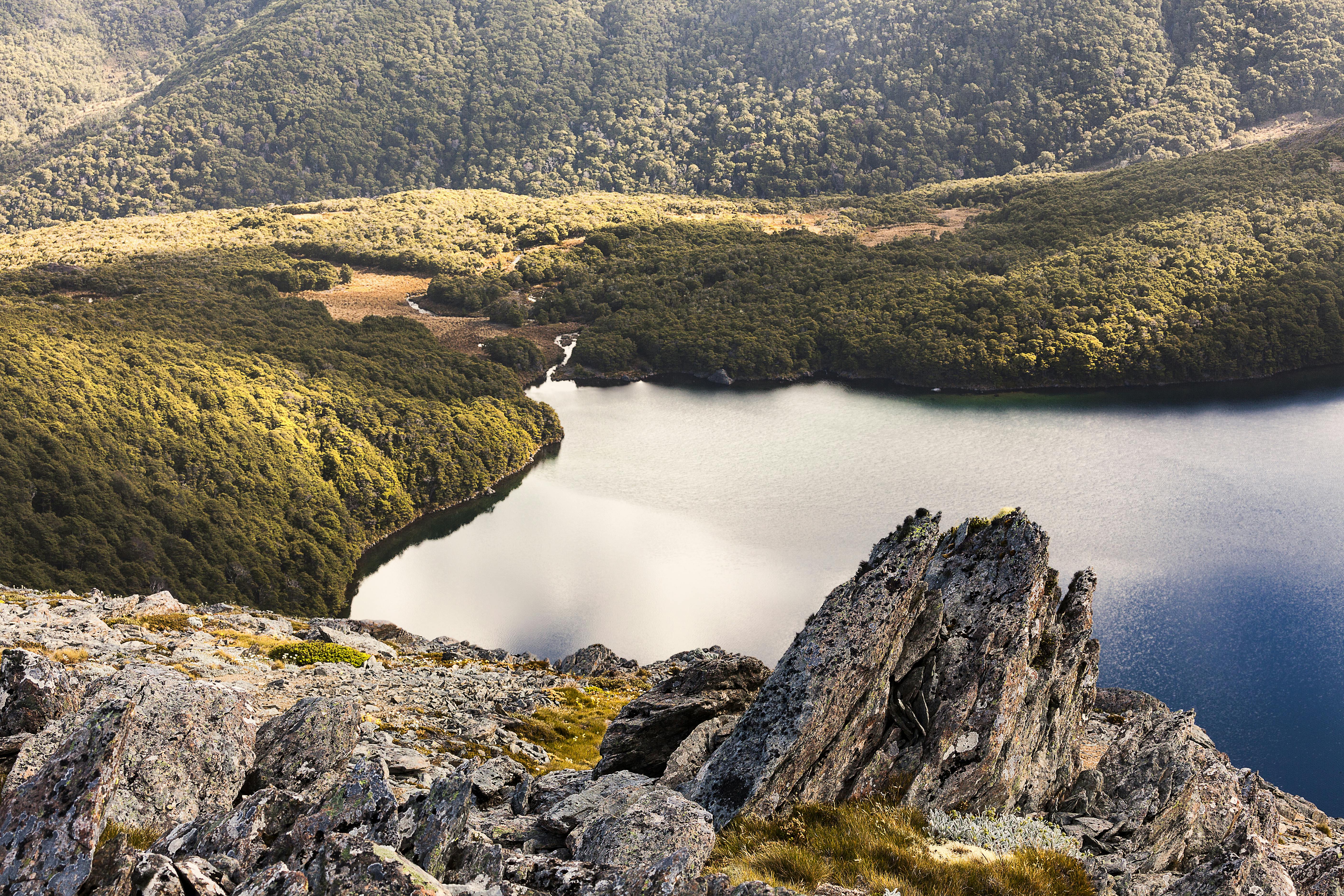
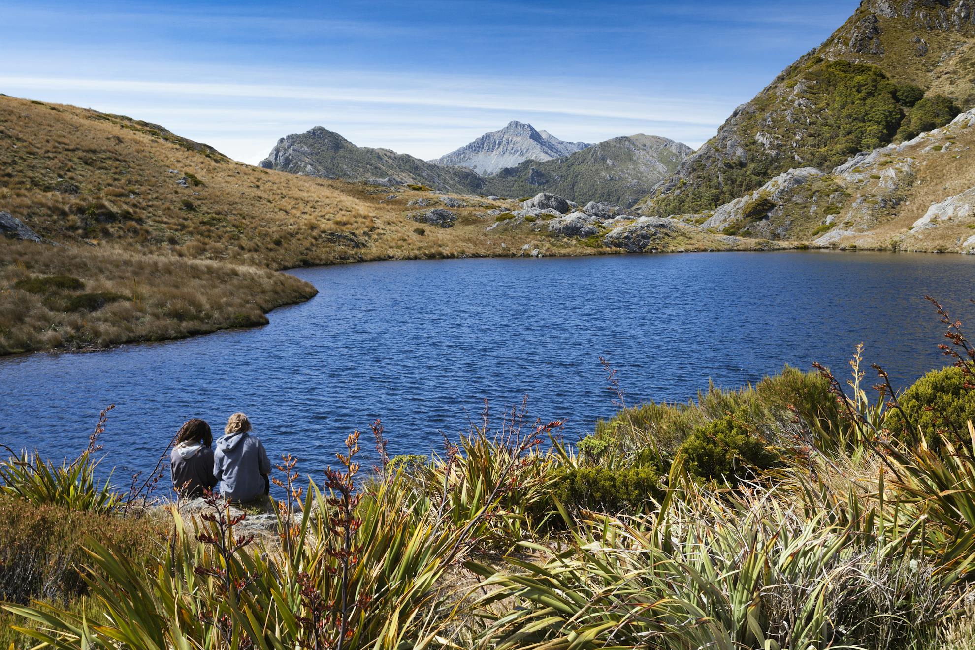
However, I am a spent force, dark clouds are approaching, so it’s down scree to an idyllic campsite beside Lake Lockett. In 10 hours, I have walked what Mackay and Captain Lockett did in two days.
An unofficial, but well-marked track puts me on the beach at Diamond Lake. Skirting around the shore, it’s a bash through wiry spaniard and across marshlands of red tussock. Choosing a grassy spur, I ascend, aching thighs slowing me to a crawl until, after a couple of hours, the ridgeline is reached. From there, 700m below, the Cobb Valley stretches out. My ancestors grazed sheep here in the late 1800s. On the other side lies Ruby Lake, tucked into a basin beneath Mt Benson, 1661m.
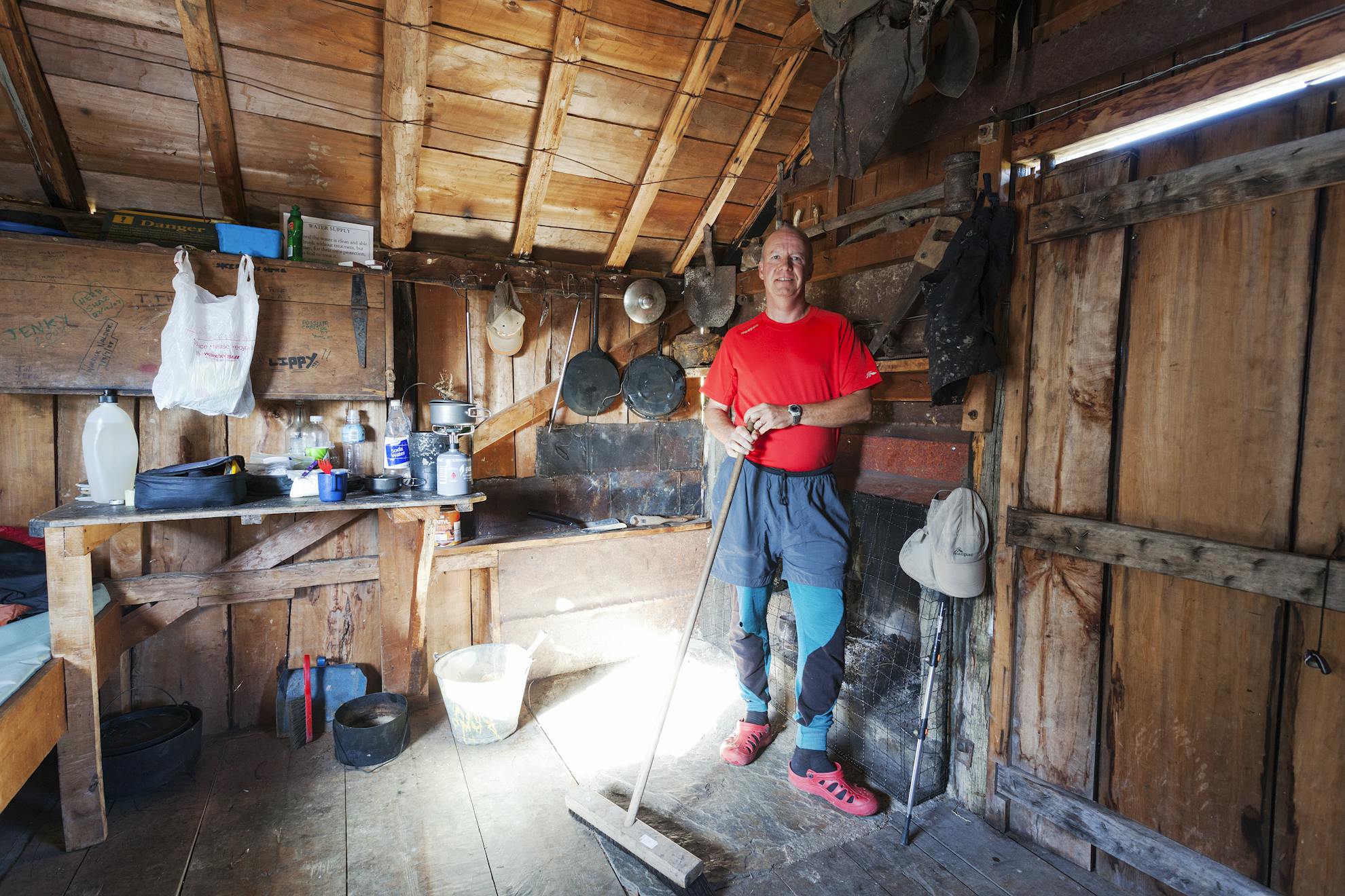
I search the rocky spire for a way forward, but am at an impasse. Worsening weather strikes a decisive chord, and for the second time in 24 hours, it’s a hurried bail off the tops for the shelter of the forest and the restored Chaffey Hut, reached just as rain begins to fall. The hut is a great example of a traditional horizontal slab hut. As I enter the tight foyer, two women make for interesting company in this 11.5m2, three-berth shelter.
I make a leisurely start up easy river flats adorned with riots of yellow Maori onion and delicate gentians. After an hour’s amble, I enter the antiquated Tent Camp.
Further up-valley, the track is a delightful stony path climbing through bonsai beech and subalpine vegetation. At Fenella Hut, I do an inventory of my food rations and sip warm mugs of tea as another cold front arrives.
Day five is blustery and I depart under a sullen sky. A quirky array of paint-tin lids nailed to trees mark a spur track to the bushline. From a saddle, rock cairns lead up the ridge, then sidle east of Waingaro Peak, along a narrow path. By the time I climb a chimney onto the northern ridge of Pt1550, I am enjoying myself.
Winding through pygmy forest, I travel north along the crest of the Douglas Range. An exposed sawtooth ridge leads up and over a tussock pyramid. A cairn here marks the scramble up Kakapo Peak, but I choose the dodgy sidle under its western flank. Frequent cairns are a comfort on an otherwise unmarked ridgeline.
I search the rocky spire for
a way forward, but reach an impasse.
For the second time it’s a hurried bail off the tops
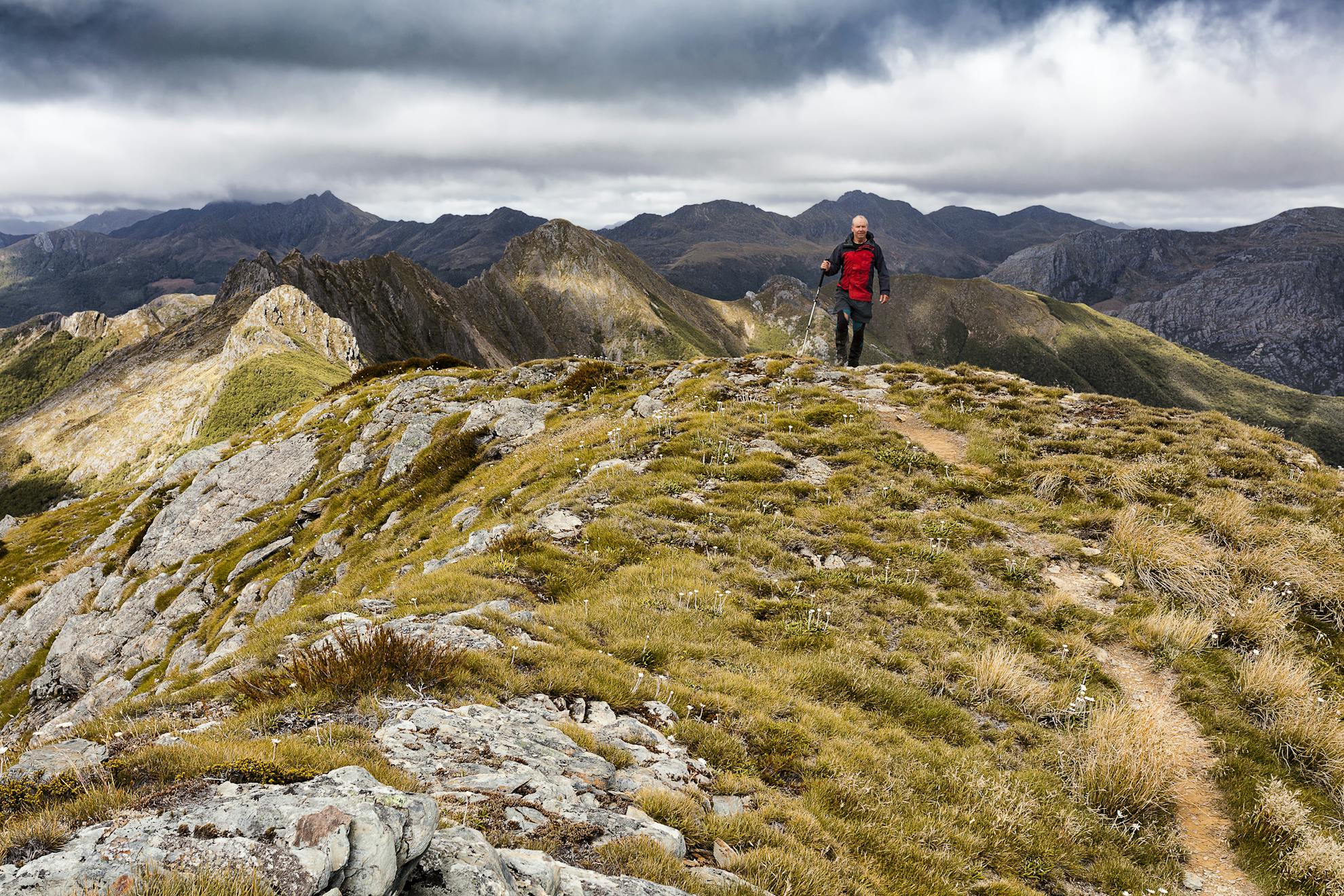
In a rare burst of sunshine, I spot the serrated Dragons Teeth, now visible to the north. These impossibly-angled peaks stab into the sky with such defiance as to pose a significant barrier, and challenge.
Good balance and unwavering concentration are needed to traverse the undulating knife-edge ridge, before a rough trail drops through stunted mountain beech and dracophyllum to Lonely Lake Hut.
I lie inside my bolt-hole reading hut literature. In the maelstrom outside, a lonesome bellbird persists in singing me his melancholy tune.
I am fascinated with the four hut books, and read the first entry dated December 1973. The building materials were flown in by the Forest Service in 1974. Frank Soper and his mate erected this ‘garden shed’. The logbook boasts numerous entries of parties writing up their route descriptions to help (or confuse) other trampers.
At 5am, I stumble outside into the prevailing silence. A porcelain moon washes out the starry sky above. I boil the billy and by 7am I start up snowgrass terraces into a picturesque cirque. A cloudless sky overhead has me in a great mood as I top out onto the saddle between Pt1630 and Drunken Sailors, where expansive panoramas open up across the Anatoki abyss to Douglas, Trident, Needle and Yuletide peaks. Beyond these imposing giants lies my goal: the hut at Adelaide Tarn, only about four kilometres away as the kea flies.
To negotiate the fearsome Dragons Teeth, there are three possible routes: The ‘high route’, which includes a vertical chimney section nicknamed ‘the wireless’ since 1994 when the cable was removed. This is best left to those with nerves of steel. Then there is my intended route, the ‘low route’, which is longer, poorly marked and includes bush-bashing and bluffs. Finally, there is the what I have dubbed the ‘slow route’ – the way I eventually went.
Sidling beneath the leaning hulk of Drunken Sailors, I fail to find any cairns. Reading a plethora of route guides adds to my confusion, so I choose to descend open, scrubby ground. Entering a tongue of forest, I sidle onto a high ridge, but this proves physically demanding, clambering over neinei and rockfall on a precipitous slope, peppered with bluffs. The only way is up. Two hours of intense struggle sees me top out, crawling on my stomach, onto the summit of a knob. Back on the usual low route, the ground trail soon evaporates into the bush as I gingerly lower myself down a steep spur, marked with spasmodic cairns, towards the Anatoki River.
Breathless, I ford the Anatoki.
Twenty minutes upstream is a small campsite affectionately dubbed Pt744. Many parties overnight here, but I persist up the faint trail for a further hour, my leaden legs dragging. Finally, after a nine-hour effort, I surrender – deep inside the headwaters of the Anatoki, only 1.5km from Adelaide Tarn Hut. Rather than push my middle-aged body to the limit of endurance, I enjoy a wash in the river.
The next day, feeling confident, I start off upstream on a rough track to the topmost forks. Veering right on a compass bearing, I gradually gain height through the beech, neinei and tangles of bush lawyer.
Two hours of climbing give me a vantage point. A colossal wall of bluffs loom over me, feeding my fear and weakening my resolve. Without an accurate position, I doubt my ability to locate the steep route through these bluffs. Caution is the better part of valour so, reluctantly, I retreat, resigning myself to the ‘slow route’.
For the next three hours I crash back through the lower Anatoki and ford the river to find the track from Lake Stanley, and promptly kiss the first orange triangle I’ve seen in six days. As clouds condense to light rain, I saunter along to Anatoki Forks Hut. This slow route will add three days to my trip.
There is an intriguing entry in the visitor book. A trio of foreign hikers were stuck here for a week. Rationing their meagre food supplies, they resigned themselves to eating snails, worms, cabbage tree, ferns and nettle. A helicopter eventually rescued them.
As the summer sun inches over the mountains, I cross the Anatoki. A marked track gradually ascends 10 promontories before reaching the formidable-looking pinnacle of Yuletide (1562m).
Each gendarme proves more difficult to negotiate. I tip-toe tentatively over huge boulder piles, ignoring the gaping exposure on either side. My arms are working overtime in a full-body workout. No longer tramping, this is rock climbing, albeit with pack and boots.
Scrambling to the top of Yuletide in gusty winds, I gaze across to The Needle. A rough route sidles beneath its northerly face, through weaknesses in the bluffs, to squeeze through the Needles Eye. Once through this saddle, an awe-inspiring panorama unfolds. Below is Adelaide Tarn, cradled into an alpine amphitheatre, surrounded by a series of gnarly peaks. Beyond are the Dragons Teeth, which have taken me three days to bypass.
Stumbling down a tussock spur and along the lake shore, I squeeze into Adelaide Tarn Hut, not much more than a utilitarian garden shed with four anorexic bunks and a small cooking bench. Plummeting temperatures see me retreat early to my bag.
From the Needles Eye, I follow a well-cairned route north. An enchanting path punches through tight scraps of bush, popping out onto sharp ridges which feature unusually-angled rock tors.
Within three hours, I have crested a grassy knob overlooking the expansive basin of Boulder Lake. From Green Saddle, I descend a spur onto the boggy flats below. Pushing through head-high red tussock, I eventually arrive at the two huts near the shore.
Skirting the water’s edge for half an hour, I take a spur track onto the shattered shoulder of Brown Cow. This mountain gives a great outlook toward the Lead Hills, where Mackay and Clark camped on their exploration of the Aorere River. An unstable scree slope is traversed to Cow Saddle. From here, the easily-graded track descends to Black Cow, meandering through patches of regenerating tea tree to bottom out across bizarre limestone formations.
Eventually, a stony road leads down to the Pomeroy farm. The farmer’s wife kindly drives me out to the Langford store in Bainham and by nightfall I have hitch-hiked back home to Nelson after completing one of the most demanding tramps I have ever undertaken.
I have come full-circle, starting out following Mackay’s footsteps over the Lockett Range; ending up in the Aorere Valley where Mackay’s first foray into Kahurangi began. I have appreciated the shelter of small, historic huts built by miners, musterers and mountaineers. I have gazed at a dozen alpine lakes and a hundred high peaks. I have walked 100km through the heart of Kahurangi’s geological dreamscape – it could have been the 1850s or the 1960s. Though these hills are riddled with human history, not much has changed. May it stay that way.
- Grade
- Difficult
- Time
- Allow 9-10 days. Uruwhenua Rd to Riordans Hut, 6-8hr; To Lake Lockett, 1-2 days; To Fenella Hut, 1-2 days; To Lonely Lake Hut, 68hr; To Adelaide tarn Hut, 6-12hr; To Boulder Lake Hut, 5-7hr; To Bainham, 6-8hr
- Access
- Access At Upper Takaka, Uruwhenua Road gives access to the Kill Devil Track. At Bainham, James Rd gives access to the Boulder Lake Track
- Map
- BP23, BP24, BN23
