


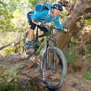
Dave Mitchell rides Taupo’s Great Lake Trail and regards it as one of the best and most rewarding cycle trails in the North Island
The 71km Great Lake Trail is one of the most engaging and rewarding rides in the North Island, offering expansive views of not only the largest lake in Australasia but Tongariro National Park’s stunning volcanoes as it wanders around the lake’s western and northern rim.
The trail started life as the W2K Track from Whakaipo Bay to Kinloch, followed by the K2K Track to Kawakawa Bay and eventually the Orakau Track to Whangamata Road car park. The completion of the Waihaha and Waihora Track sections from Waihaha Bridge to Waihora Bay in 2014 signaled the trail’s official opening. It’s a ‘hub and spoke’ arrangement centered on Kinloch, with shuttles and water taxis providing the vital links to trail heads and ends.
Lake Taupo is in fact a caldera that was formed by a super-volcanic eruption around 26,000 years ago. It has erupted 28 times since with the last, 1800 years ago, being so powerful it is thought to have been the world’s largest eruption over the last 70,000 years.
But the fast-draining pumice soil produced by that eruption has proved the perfect building blocks for an all-weather bike track.
There are six sections of trail that form the spokes, with Kinlock being the central hub to roam from. The Y2K, K2K and Orakau sections can be ridden in isolation and in either direction by using a shuttle or as out-and-back rides.
The Waihaha and Waihora sections come with the option to take a water-taxi back to Kinloch, adding to the adventure.
1. Waihaha Section
12.5km, 1.5hr, Grade 3 (intermediate)
This benched track is well graded and follows the volcanic rim’s gullies and undulating contours. The trail heads east beside the Waihaha River, past a DOC shelter, interpretive panels and over a low swingbridge. It’s a wide graded track that undulates through stunted bush and ignimbrite rock. The Waihaha River disappears spectacularly into a deeply cut gorge of waterfalls and bottomless pools.
Access is by shuttle service from SH32 – Western Bay Road.
2. Waihora Section
17km, 2hr, Grade 3 (intermediate)
This section drops more than 100m to a spectacular cliff-top lookout over the lake. The trail then climbs steadily to Te Poroporo Point where it crosses Ouapoto Stream and weaves its way onto the crater rim for a final amazing switchback descent down the fern and fuchsia-lined Kotukutuku Stream gully to the pumice sands of Waihora Bay.
Access is from Western Bay Road. Take a water taxi back to Kinlock.
3. Orakau Section
9.5km, 1hr, Grade 3 (intermediate)
The pine-needle covered track descends through a stand of old man pine, then follows Orakau Stream through the Harakeke Wetlands. Wetland restoration, predator control and wilding pine eradication are a feature of this area and a credit to local volunteers. The track ends at the Kawakawa Bay campsite.
Access is by shuttle service from the second DOC car park on Whangamata Road.
