


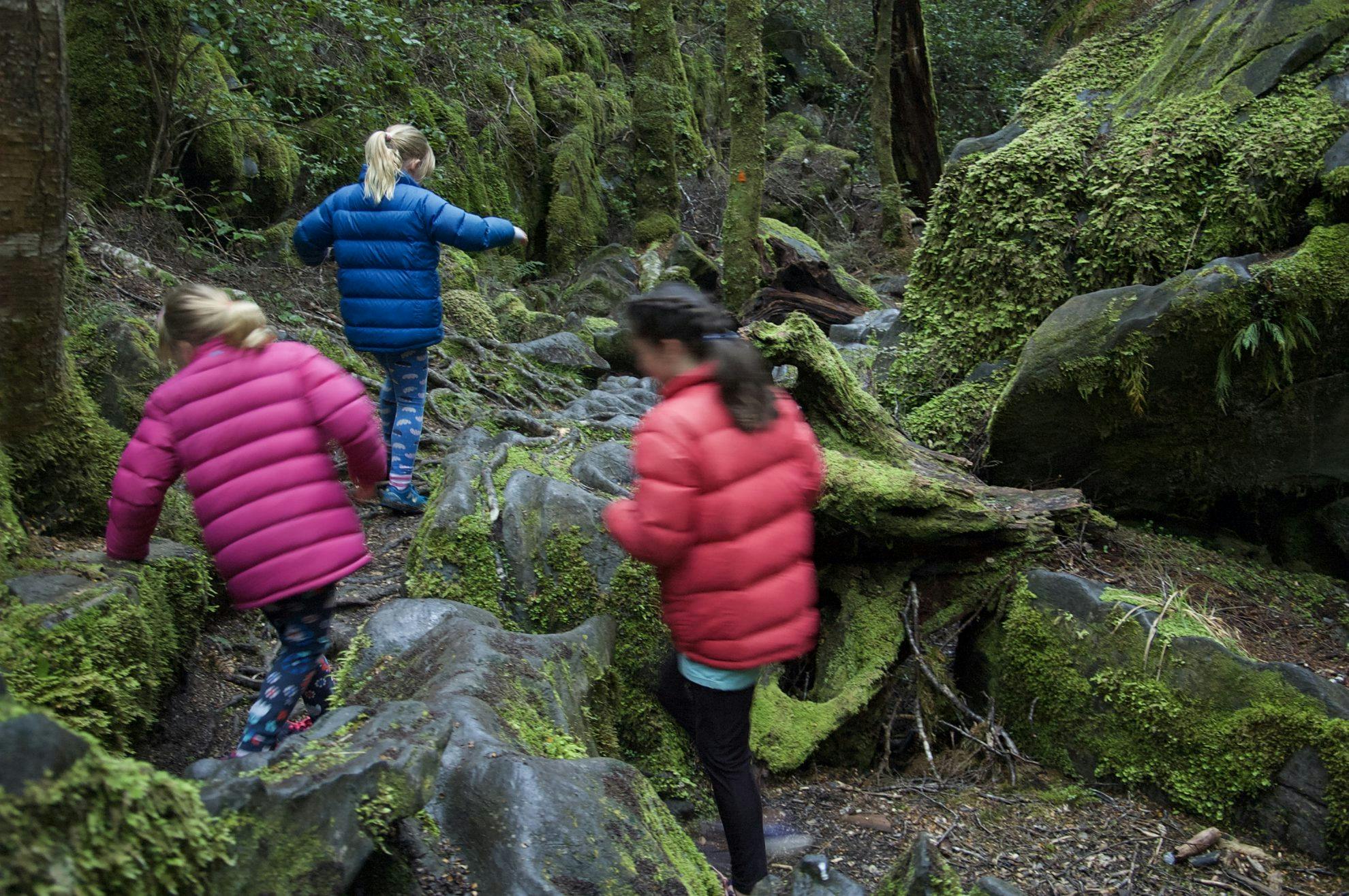

The school holidays are upon us and while many head away for a few weeks of beach-side camping, the perennial problem of what to do with the kids will undoubtedly rear its head.
Maungauika/North Head, Auckland
In the 1880s, when the Russians were the enemy, the government constructed coastal defence systems as a deterrent. The three guns were state-of-the-art and the barrels alone weighed 13 tonnes. An example still remains at the South Battery.
By the time the Second World War arrived, North Head was used as the defense headquarters for Auckland. An anti-submarine boom pincered any attacking vessels with two guns at sea level.
The series of guns, tunnels and emplacements are now easy to explore on a network of tracks.
There is a Coastal Loop (30 minutes one-way), Summit Loop (25 minutes one-way) and Tunnels Loop (20 minutes one-way).
The tunnels are always a winner with kids.
Access Signposted in Devonport
Time 2hr
Pukaha National Wildlife Centre, Wairarapa
The wide and level track is suitable for strollers and passes through the regenerating forest of Mt Bruce.
The loop periodically passes aviaries, which enclose species such as hihi, kokako and kaka. Interpretation panels and benches punctuate the walk. There is also a short detour to the Campbell Island teal enclosure and kiwi house.
Informative displays on the background to Mt Bruce explain the decline of New Zealand’s avifauna, with particular attention to the role of predators.
Mt Bruce is one of the few places where you will get a chance to view endangered New Zealand bird species up close. The aviaries allow intimate viewing, especially attractive to children, who will have little chance of viewing the birdlife elsewhere.
Tickets cost $20 for adults and $6 for children over five.
Access 11km south of Eketahuna on SH2
Time 40min
Trounson Kauri Park, Northland
In 1890, James Trounson set aside 3.14ha of land for a reserve, which is now 457ha in extent.
The track is wide, even and metalled. It performs a loop through the forest, over a substantial boardwalk and alongside a stream. There are information panels and even audio recordings providing commentary to help children understand the kauri and ecology of the forest.
As the birdlife here is more prolific than elsewhere, you can spend time with the kids just observing the birds. There is also a campsite, which provides an excellent opportunity to see the resident kiwi at night.
Access Signposted from SH12
Time 40min
Kahikatea Walk, Coromandel
Between 1871 and 1928, more than 100 dams were built in the Kauaeranga Valley. The Model Dam is a one-third replica of the Tarawaere Dam built by Jim Angel in 1920.
The Kahikatea Walk loops over the dam and back to the Visitor Centre, passing beside a concrete structure of the Thames Water Race. The track is metalled and has boardwalks over the wetter ground. For added interest, the local DOC office has created a ‘treasure hunt’ on the walk. Young walkers can inspect 10 treasure chests, containing conservation questions which they then answer and can have checked by a ranger at the Kauaeranga Visitor Centre.
The water race supplied the burgeoning town of Thames with water between 1876 and 1945. It was originally constructed to power stamper batteries. It was 14km long, flowed into the Waiokaraka reservoir and cost £80,000. It was such a significant undertaking that the amount of timber and roading required for its construction had the effect of opening up the valley for subsequent logging.
These reconstructions provide living history lessons for children and bring alive the stories they have read about New Zealand’s early pioneers.
Access The track is signposted at the Kauaeranga Visitor Centre
Time 20min
Nga Taonga Nature Walk, Wellington
The gentle, wide track threads through lush forest past information panels to a junction after 15 minutes.
You can either return via the road (10min), or continue along the Nature Trail (15min).
Detailed information panels name numerous specimens alongside the trail and highlight interesting and little-known facts about the plants found on the trail. This is a good educational walk.
Access On Coast Road, 12km south of Wainuiomata
Time 30-45min
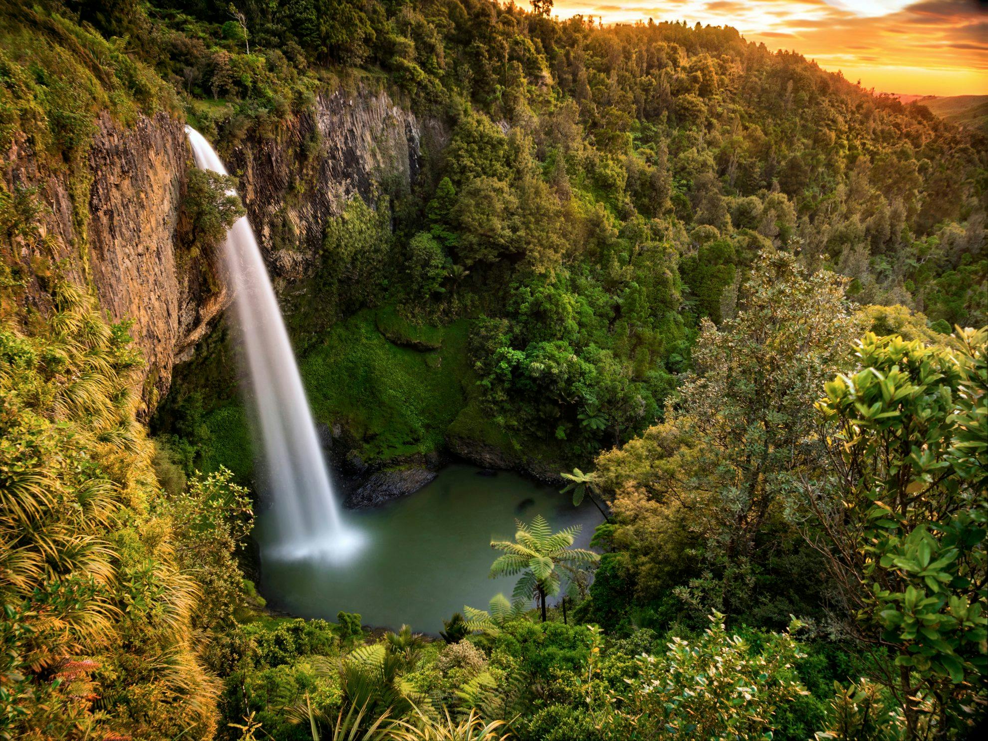
Bridal Veil Falls, Waikato
Bridal Veil Falls is one of the most spectacular waterfalls in the country, with viewing platforms perched in all the right places.
There’s some fine tawa forest on the way to the top lookout. Head right, down the 261 steps, to another two lookouts and the bridge and viewing platform at the base of the falls.
Counting steps on the way up is a good distraction for shorter legs.
The fluted hexagonal basalt columns are an impressive backdrop to the 55m high falls. The Maori name for the falls – Waireinga – means ‘leaping waters’, an allusion to the spirits which jump over the falls. To local Maori hapu, the area was known to be inhabited by patupaiarehe. These forest fairies are felt as guardians of the area.
Access Signposted 20km from Raglan
Time 10-30 minutes
Tumanako Loop Track, Hawkes Bay
The trail passes through a variety of forest types and is a wonderful example of how DOC is not only restoring mainland islands such as Boundary Stream, but is making concerted efforts to educate people about their work.
As well as highlighting rare plant species such as neinei, kaka beak and mistletoe, the information provided also describes how they were lost (predation, logging, introduction of weeds). Other panels are devoted to the methods DOC is using to aid their recovery and details of the encouraging results.
To aid the flow of the lavishly-illustrated information panels, this walk is best attempted in a clockwise direction.
Access From SH2, take Matahoura Road and then Pohokura Road
Time 45min
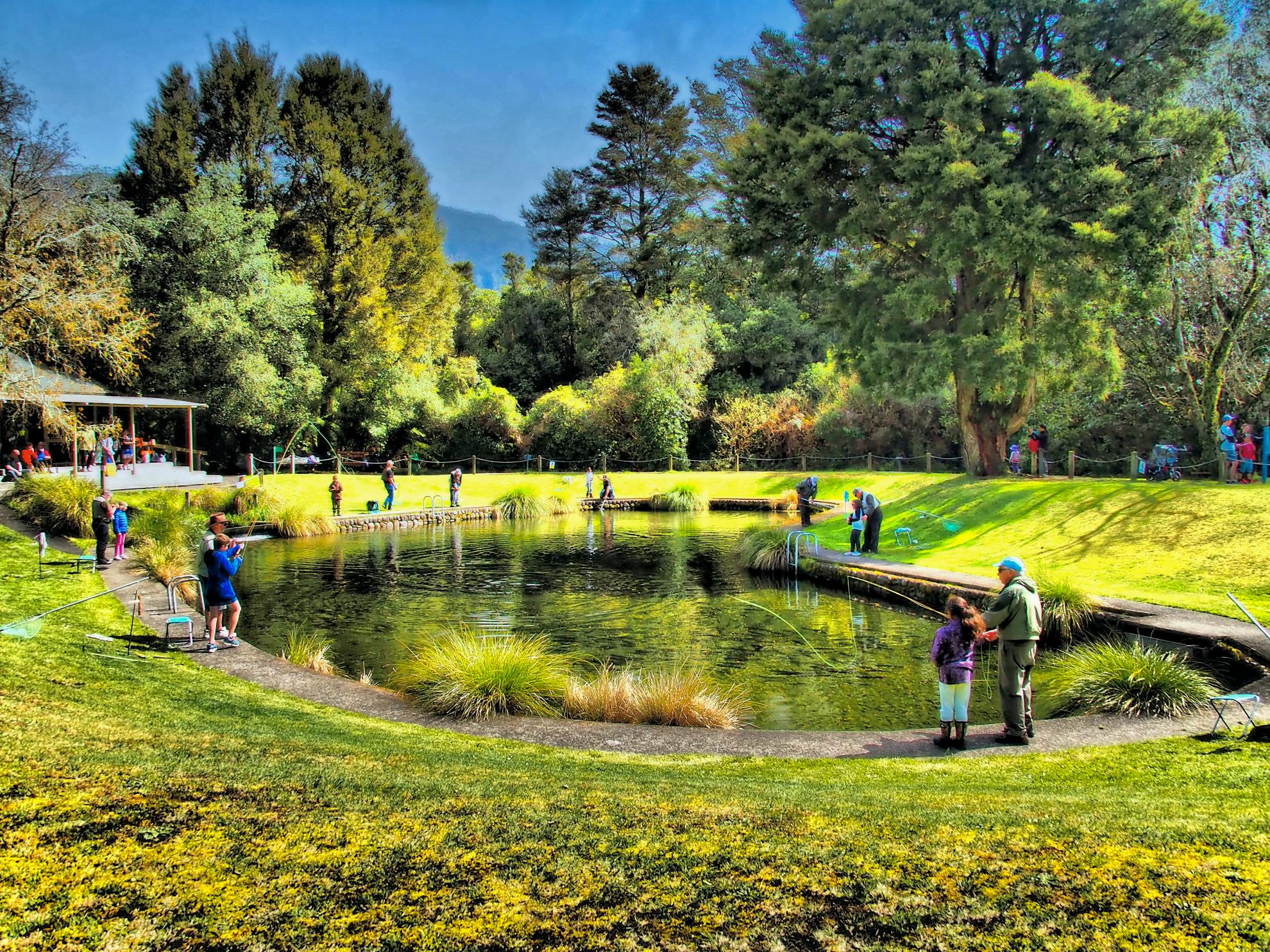
Tongariro National Trout Centre River Walk, Taupo
The centre is well set up for kids and features an aquarium, hatchery and museum. The river walk passes many of the buildings and infrastructure responsible for raising trout once used to populate the country’s waterways. Numerous interpretation panels explain the many facets of trout and their place in New Zealand lore.
Pick up a map of the walk as there is a labyrinth of pathways and roads around the centre and it can be hard to know which path to take.
Children are free when accompanied by a paying adult ($15).
Access Signposted 5km south of Turangi on SH1
Time 20min
Nikau Loop Track, Hawkes Bay
The Nikau Loop Tack is the hub of the track network at Morere Springs with several other tracks radiating
from the loop.
The initial 10 minutes to Nikau Pools is sealed and has plenty of benches. It’s soon apparent how the walk got its name. The abundance of nikau create a jungle-like quality to the forest and you almost expect snakes to dangle from the branches and monkeys to dance around the tree tops.
From the picnic benches by the pools, skirt around the bathhouse and cross two bridges. The surface becomes a little more uneven with occasional tree roots to negotiate.
Take togs – the pools occupy the site of the former Number 2 bath house, which was fed via wooden pipes from the spring further up the valley. With the languid nikau fronds draped over the pools, you could be forgiven for thinking this is the tropics.
Access Morere Springs, 8km north of Nuhaka and 58km from Gisborne
Time 30min
Te Aroha Domain Loop Walk, Bay of Plenty
The 44ha Te Aroha Domain was gazetted as a recreation ground in 1881 and has been restored with such painstaking attention to detail that you almost expect a sophisticated Edwardian lady to swan past at any moment. Wrought iron lamps, carved fountains and colonial-style buildings exude the elegance which made it a preferred destination for the ‘carriage trade’ to ‘take the waters’.
The Domain Upper Walk climbs gently and undulates through native forest. Continue right on the Domain Lower Walk to return to the Mokena Geyser.
Geothermically-heated swimming pools are the reward for the walk, and the Mokena Geyser is the only natural hot soda spring geyser in the world. It ejects a 5m jet of water every 40 minutes, which children find mesmerising.
Access From the Mokena Geyser, Te Aroha Domain
Time 15-30min
Bushy Park, Whanganui
Behind Bushy Park homestead is a harness room, small museum and interpretation centre with information on the projects and ecology of the park.
The track network explores lowland podocarp forest, brimming with birdlife. The highlight of the walk is ‘Ratanui’, thought to be the largest northern rata in the North Island. It is 43m tall, with a trunk diameter of 3.77m and a girth of 11.86m. A twisted mat of fused convoluted roots descend the massive trunk.
Liberally-placed interpretation panels identify different species and provide botanical facts and uses for the leaves, bark and wood.
The homestead is open to visitors and is a step back into the stately world of times past. Vast collections of photographs and paintings relating to New Zealand’s flora and birdlife adorn the high studded walls. It’s a good counterpoint to the natural attractions for children to experience how the landed gentry of early New Zealand lived.
Admission costs $4 for adults and $1 for children.
Access Just north of Kai Iwi, take Rangitatu East Road for 8km
Time Up to 2hr
Cape Foulwind Walkway, West Coast
This is one of the best places to observe a fur seal colony. Want to know how pups learn to swim? Or land on the rocky shores? How do males stake out their territories?
This is a natural history programme – and soap opera – played out live.
While younger kids can watch the seal action, older children can complete the Cape Foulwind Walkway, a two-hour return walk.
The well-formed track skirts the headland with viewpoints over Tauranga Bay and then the seal colony. There’s a huge wooden viewing platform from which to observe the seals.
This is a permanent colony. Males arrive in November and December to stake out territories. This is a battlesome affair, with huge chunks of blubber being removed from their thick skins by sharp teeth. Darwin all the way. Females who occupy their domain are theirs for the taking. Males then leave, kick back for the rest of the year and go fishing.
Females nurture their young, suckle and conduct courses in swimming. Nurseries of pups are often witnessed trying to avoid being pulverised on the rocks by the crashing breakers. Once weaned, they must then avoid being eaten by orca or sharks.
Access From Lakehouse Road, Westport
Time Up to two hours
Onamalutu Scenic Reserve, Marlborough
The podocarp forest is the only remnant of the valley floor forests which once covered the Wairau Plains. Kahikatea, matai and totara are the main representatives and tower up to 50m over the trail. A ring of kahikatea encircles the southern end of the reserve, while to the north the peaks of Mt Richmond Forest Park poke through the forest. A network of short walks weaves in and out of the podocarp forest. One track leads to Birdlip Stream, with an inviting swimming hole.
There’s a large grassy clearing with campsite, toilets and picnic table, making this a perfect spot for a camping trip with the kids.
Access From Onamalutu Road, north of Renwick and off SH6
Time 20min

Ulva Island, Stewart Island
Ulva Island is an open sanctuary, free of predators and available for the public to visit.
All the ingredients are present for a glimpse into the past, to a New Zealand before human settlement: a forest free of mammalian browsers, an absence of hungry rats, birds free to breed without perpetual threat, chicks with odds of survival stacked in their favour, a well watered forest floor with a cache of insects. This is as close as anyone in New Zealand can get to feeling the echoes of life’s ancestry.
There are several meticulously- maintained walking tracks on the island including Flagstaff Point Lookout, Boulder Beach and Westend Beach.
All through the forest are benches, and here’s the trick: don’t move.
Sit on a bench and wait. Spend an hour. The birds will come to you. Lie back and close your eyes. Listen all around. Pick up their calls from a distance. Make a mental map of where they are. Watch which plants are in flower and which have berries on them. Coprosma with bright red fruit is always a good one. Pick a place by a food source and wait.
And then you may start to gain a glimpse into the New Zealand that was.
Access Many operators on Stewart Island operate water taxis
Time 3-4hr
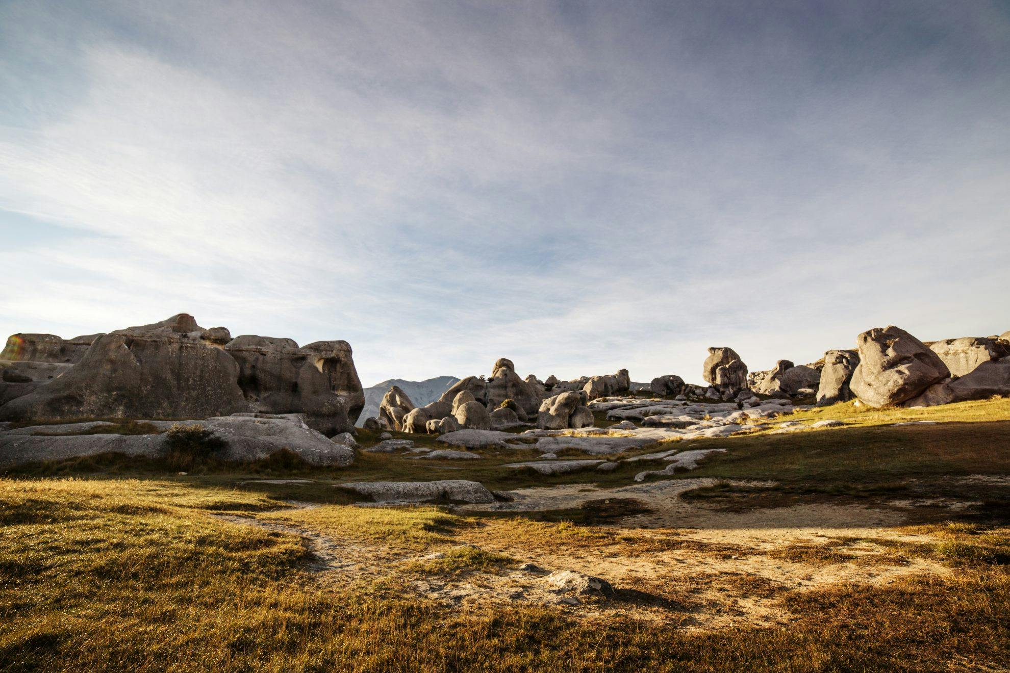
Kura Tawhiti Access Track, Canterbury
Castle Hill/Kura Tawhiti is a special place. For Ngai Tahu, there is a topuni – a symbolic cloak of protection enrobing the land. Their stories are interwoven with this landscape.
For others, Castle Hill represents the spiritual heart of New Zealand, a place akin to Glastonbury or Cusco on other continents. Whatever your beliefs, there is an undeniable power here.
The limestone formations are a photographer’s dream – the play of light, shapes and shadows is mesmerising. For children, it is a natural maze of delight and adventure, although they should be closely supervised.
Follow the metalled track to the grassy areas and then explore at leisure.
The tilted beds of limestone at Castle Hill are said to be home of the patupaiarehe, light beings akin to fairies.
The area around Kura Tawhiti was a stopping off place for Maori travellers searching for greenstone.
Access From Castle Hill/Kura Tawhiti Conservation Area, 2km south of Castle Hill Village
Time As long as you like
Monkey Island, Southland
You can only cross to Monkey Island at low tide. A short stepped climb leads to a viewing platform from where the entire sweep of Te Waewae Bay can be viewed, with the Hump Ridge and southern Fiordland mountains providing a spectacular backdrop.
Kids can run free on the vast sand flats, and it’s good fun climbing to the viewing platform.
Access Signposted between Colac Bay and Orepuki
Time 10min
Grove Scenic Reserve, Nelson
The limestone architecture and nikau forest, protruding at all sorts of funny angles, make visitors to Grove Scenic Reserve feel like they’ve stepped through a portal to another world – and kids will love it.
The reserve has a labyrinth of leafy mini-canyons to explore. Although there is a formal track which leads to a lookout over the lower Takaka Valley, the real fun is in going off track and getting lost.
This karst limestone has been eroded and weathered to form a convoluted landscape. These are some of New Zealand’s oldest rocks, formed in the Ordovician Period between 443 and 490 million years ago.
Access Take Abel Tasman Drive until Clifton. The Grove is signposted on the right
Time 20min
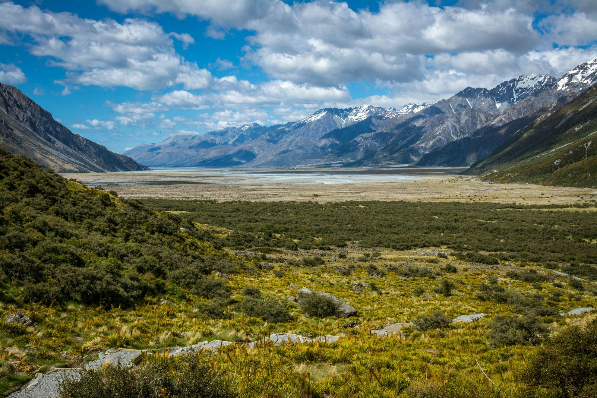
Blue Lakes and Tasman Glacier Walks, Aoraki/Mt Cook
A view down the terminal lake of the Tasman Glacier – New Zealand’s longest glacier at over 23km – is not only spectacular, but graphically demonstrates a glacier in retreat. This is a wild and raw place with high mountains; but close to the trimmings of civilisation.
From the car park, the metalled track climbs over 70m to the top of the terminal moraine above the lake.
During the last Ice Age, the glacier was up to 2km deep and extended 10km past the current shore of Lake Pukaki. A series of photos on a revolving sign at the lookout show the glacier’s height in recent times, demonstrating the rapidity of its retreat.
Access Tasman Glacier car park
Time 40min
Te Anau Bird Sanctuary Walk, Fiordland
The metalled track leads to the bird sanctuary where a series of tracks weave over the sloped grass areas between enclosures.
The sanctuary provides an opportunity to witness, at close quarters, a selection of New Zealand’s rare and endangered birds which you would not normally encounter in the wild. Children love it here.
Pride of place are the takahē, which roam in a predator-proof enclosure designed to keep rats, stoats and cats at bay. Their enclosure looks out to the Murchison Mountains, one of the bird’s last strongholds in the wild.
Other aviaries house kea, kākā, Antipodes Island parakeets, yellow and orange fronted parakeets, kereru, morepork and weka.
Most birds at the centre were either abandoned, orphaned or injured and form breeding pairs for later release back into the wild.
Access From Fiordland National Park Visitor Centre, on the corner of SH94 and SH95
Time 30min
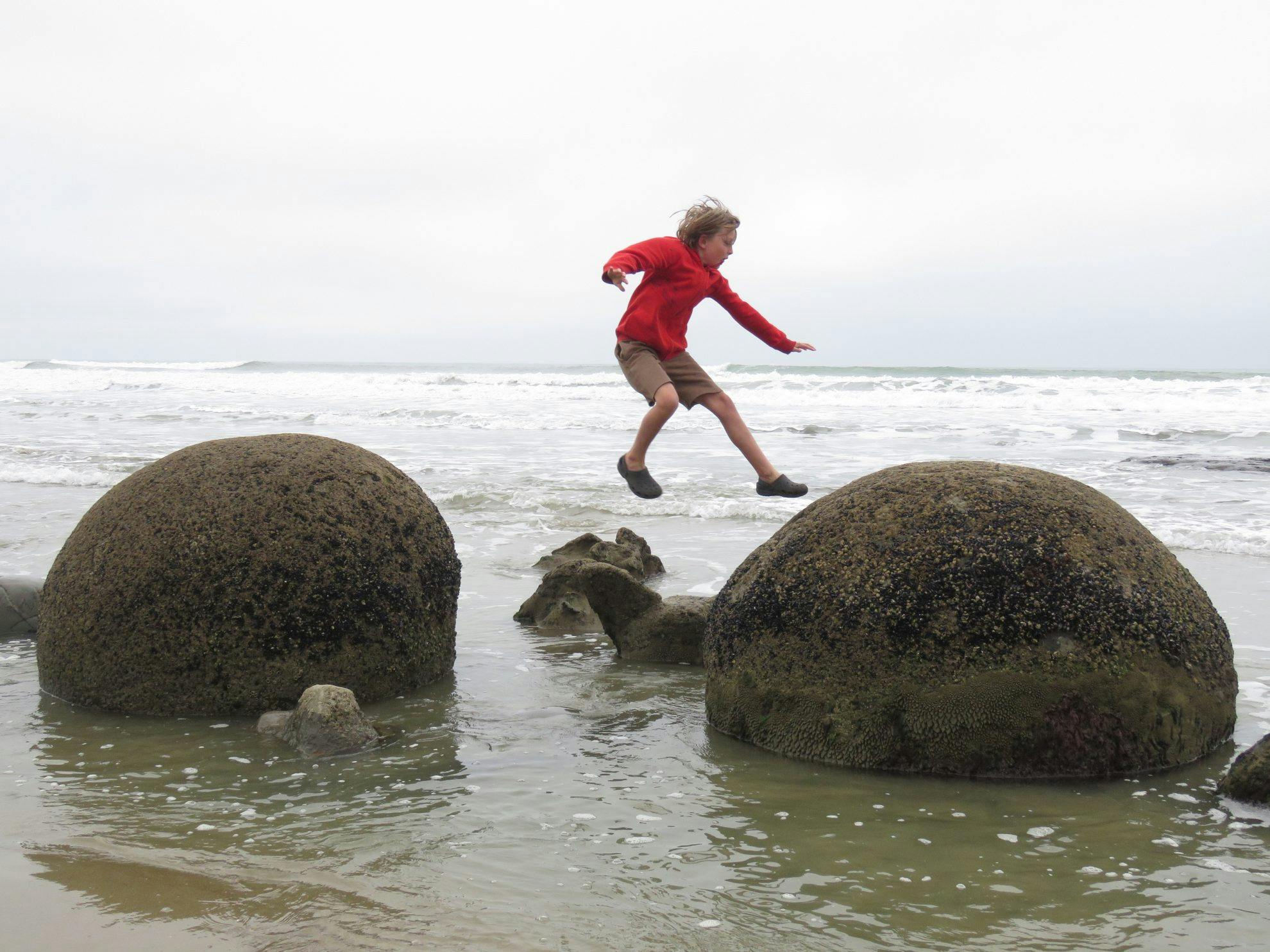
Moeraki Boulders, Otago
Moeraki Boulders are geological curiosities. The largest is over 2.2m in diameter and weighs more than seven tonnes. There are more than 50 boulders strewn like dinosaur eggs along the beach. The biggies took around four million years to form. Geologists term them septarian concretions.
The boulders are best exposed three hours either side of low tide. If a big swell is running, you may not be able to get to the boulders at any tide.
To find the boulders, descend to the beach and head left. Standing on one leg atop a boulder seems to be the de rigeur pose.
Access Well signposted from SH1 between the settlements of Hampden and Moeraki
Time 10min
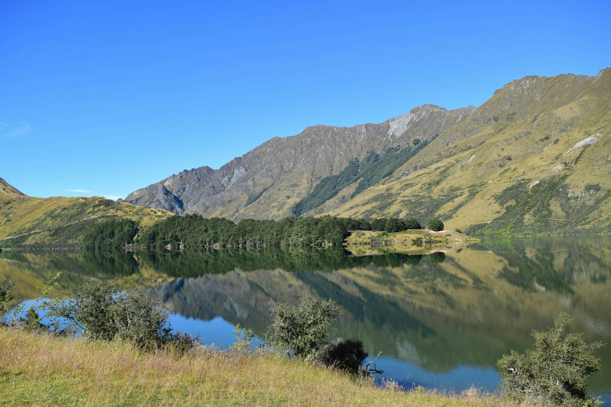
Moke Lake Loop Track, Queenstown
Although Queenstown – and all the bustle – is only a short drive away, you would never know it up here, surrounded by pointed schist hills,
a few sheep and a tranquil lake.
Follow the road to the signpost, cross the stile and follow the boardwalks. The track is easy to see on the far side of the lake. After about 20 minutes, a short detour leads to the snout in the lake, with a nice stand of beech forest. This is a good turnaround point with younger kids.
The views on the way around take in the Williamsons Spur to the east and the flats of Moke Creek, which wind around Ben Lomond (hidden from view). The pinnacle of Bob’s Peak is the centrepiece.
Access From Moke Lake Road campground
Time 2-3hr
